If you are interested in camping, mapping, and collecting 360 photos on Santa Catalina Island, then join MaptimeLA for the fun! Click below for more info.

If you are interested in camping, mapping, and collecting 360 photos on Santa Catalina Island, then join MaptimeLA for the fun! Click below for more info.
California Geological Survey. Fault evaluation report for Apple Valley North, Cougar Buttes, Fairview Valley, Fifteenmile Valley, and Lucerne Valley quadrangles, San Bernardino County, California. 5 maps, scale 1:24,000. Sacramento: California Geological Survey, Fault evaluation report no. 262. Web access: http://www.conservation.ca.gov/cgs/rghm/ap/Pages/official_release.aspx
California Geological Survey. Fault evaluation report for the Echo Lake and Emerald Bay quadrangles, El Dorado County, California. 2 maps, scale 1:24,000. Sacramento: California Geological Survey, Fault evaluation report no. 261. Web access: http://www.conservation.ca.gov/cgs/rghm/ap/Pages/official_release.aspx
De Long Company. De Long wine map of California. 2 maps on 1 sheet, scale ca. 1:720,000. North Las Vegas, Nevada: De Long Company, pub. 2015. Web access: https://www.delongwine.com/products/california-wine-map
DeLorme (Firm). California: detailed topographic maps : back roads, recreation sites, GPS grids : family outings, boat ramps, campgrounds, places to explore. 1 atlas (160 pages), scale 1:200,000. Yarmouth, Maine: DeLorme, 4th edition, pub. 2015. ISBN: 9780899333830
Kappa Map Group. Northern California: city, state & regional maps. 1 atlas (64 pages), scales differ. Blue Bell, Pa.: Kappa Map Group, pub. 2014. ISBN: 9780762584611
National Geographic Maps (Firm). Death Valley National Park. 1 map, scale ca. 1:165,000. Evergreen, Colo.: National Geographic Maps, Trails Illustrated map 221, pub. 2014. ISBN: 9781566953214
National Geographic Maps. Los Angeles, DestinationMap: city map & travel guide : points of interest, additional inset map, transit system, travel information, top attractions, 3D buildings, airport terminal maps, regional map, photos. 1 map, scale ca. 1:240,000. Evergreen, Colo.: National Geographic Maps, pub. 2015. ISBN: 9781597750929
National Geographic Maps. Southern California guidemap: road map & travel guide. 1 map, scale ca. 1:2,050,000. Evergreen, Colo. National Geographic Maps, pub. 2015. ISBN: 1597750158; 9781597750158
O’Callaghan, Aaron. Sacramento Valley breweries. 1 map, scale not given. Sacramento Area Brewers Guild, 2016. Web site: http://sacbeerweek.com/breweries/
One Tam (organization). One Tam, many friends. 1 map, scale not given. Tamalpais Lands Collaborative, pub. 2016. Web access: http://www.onetam.org/map-and-trails
U.S. Bureau of Land Management. California public lands, national system of public lands: Inside, About BLM California, 2016 California public lands facts, BLM California priorities. 1 map, scale not given. Sacramento: U.S. Bureau of Land Management, pub. 2016.
U.S. Bureau of Land Management. Imperial Sand Dunes Recreation Area. 1 map, scale ca. 1:150,000. El Centro, CA: U.S. Bureau of Land Management, pub. 2016.
The USGS Coastal and Marine Geology Program (CMGP) National Assessment of Shoreline Change Web Mapping Application provides a national map view of short and long term shoreline change evaluations, and historical and modern shorelines. This map includes data layers compiled in support of the U.S. Geological Survey’s (USGS) National Assessment of Shoreline Change Program.
The US Geological Survey (USGS) and the Association of American State Geologists (AASG) have worked together to build the National Geologic Map Database (NGMDB). The NGMDB is mandated to be a standardized, “national archive” of geoscience information (maps and reports, both published and unpublished), made available to the public to support decision-making, research, and other needs. Its website opened in 1996, and it currently serves about 60,000 users each month, who make about 220,000 visits.
The principal sections of the NGMDB are: Continue reading
“Art Meets Maps” is an exhibition of pictographic maps at the Map and Atlas Museum of La Jolla, in La Jolla, San Diego. Pictographic maps are maps that mix cartography, art, and illustration. The exhibition includes nine pieces made by British artist and illustrator MacDonald Gill. Continue reading
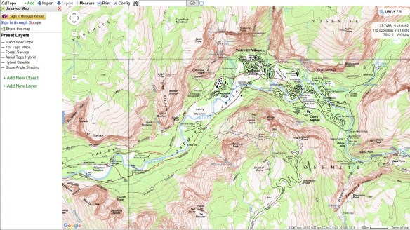
If you need to plot out a hiking route, try CalTopo. CalTopo allows you to print USGS topo maps using the 1:24000 USGS scale. You can also measure the length of your hikes and compute elevation profiles. Check it out!
Check out this essay comparing the cartography between Google Maps and Apple Maps. In summary:
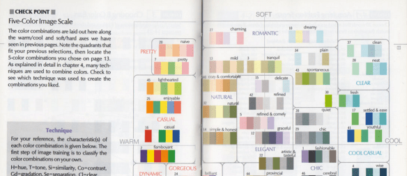
Trying to find that perfect color palette for your choropleth map? Check out this posting about using the right tool to choose that perfect set of colors for data visualization.
The US Wildfire Activity Public Information Map shows US wildfire locations, both active and recent, and other sources of information related to wildfires, including social media. The map contains live feed sources for US wildfire reports (I-209), perimeters, MODIS hot spots, wildfire conditions / red flag warnings, wildfire potential and weather radar. Each of these layers provides insight into where a fire is located, its intensity and the surrounding areas susceptibility to wildfire. Check it out!

It is not much of a place to visit. In the middle of a vast ocean with no land in sight with the only distinguishing feature being a lonely buoy. Seems like a “non-place”, but you might be surprised to learn that your GIS has probably visited the place a few times, maybe quite a bit. Add up all the operating GIS’s in the world and it may be the one of the most visited places on Earth … Null Island at 0,0.

