If you missed your favorite workshop at the 2017 ESRI UC in July, there are 51 of them that you can watch online. From ArcGIS Enterprise to ArcGIS Pro to ArcGIS Online, there is something there that might interest you. Check them out!


If you missed your favorite workshop at the 2017 ESRI UC in July, there are 51 of them that you can watch online. From ArcGIS Enterprise to ArcGIS Pro to ArcGIS Online, there is something there that might interest you. Check them out!
During the Great Depression, President Franklin D. Roosevelt promised the American people a “New Deal”. From 1933 to 1943 a constellation of federally sponsored programs put millions of jobless Americans back to work and helped revive the economy. The result was a rich landscape of public works projects across the nation. No city , town, or rural area was untouched. Hundreds of thousands of roads, schools, theaters, libraries, hospitals, post offices, courthouses, airports, parks, forests, gardens, and artworks – created in only one decade by our parents and grandparents – are still in use today!
To mark the 70th anniversary of the first supersonic flight on Oct. 14, 1947, following the formal ceremony Edwards Air Force Base will launch two formation flights which are scheduled to pass over Southern California schools October 13 as part of its outreach to support STEM (Science, technology, engineering, and mathematics) education.
The first formation – two F-16 Fighting Falcons, a B-1B Lancer and an F-18 Hornet from NASA – will fly on a route over the Antelope Valley and Bakersfield, California.
The second formation – an F-16 Fighting Falcon, F-15 Eagle, F-22 Raptor and F-35 Lightning II – is scheduled to fly a flight path over several cities in Southern California, including, San Bernardino, Colton, Riverside, Costa Mesa, Long Beach, Rancho Palos Verdes, Agoura Hills, Simi Valley, Granada Hills, and Santa Clarita, Canyon Country and Palmdale.
Both flights paths will be at an altitude low enough for easy viewing by the general public and will take place between noon and 1 pm Friday. The jets will pass over selected schools.
On Friday at 11 am, F-16 and F-18 sonic booms will be heard to kick-off the Team Edwards Day Ceremony. Other sonic booms will be executed at 1:30 to 2 pm and 6 pm Friday, and 7 to 7:16 am on Saturday. Click below for more info.


I thought of using a title for this post like “He Totally Messed Up The Map And You Won’t Believe What Happened Next” just to get you to click, but I settled for the one above instead! 😀
Now that I have your attention…
If you are using GIS in a city or county government in Los Angeles County or Orange County and you have a public web site for your GIS maps and apps, please help me out!
Please check the SoCalGIS Resources page and make sure that the link to your city or county web site is correct. If the URL has changed or your site is missing from the list, please let me know via email.
And if you have other resources you use that you think would be a good idea to have on the SoCalGIS site, let me know about that too!
Thanks.
mike
At the end of September 2017, the USGS discontinued service to the previous versions of the National Map viewer application. This was done to move toward frameworks that support HTML5 web environments, improve mobile access, add GIS capabilities, and minimize having to maintain custom viewer code.
The National Map Advanced Viewer application is now an ArcGIS Online viewer for public use. It was built using ArcGIS Online Web AppBuilder. Click below and give it a spin!
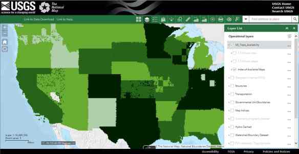
The help doc for the new viewer can be found here.
Note that the USGS already has a separate application focused on data download and that download functionality is not part of the new viewer application at this time.
The 3D Elevation Program (3DEP) is a national program to help generate new high resolution elevation data to serve multiple applications. For the past several years, 3DEP has issued an annual Broad Agency Announcement (BAA) to solicit interest in partnerships to generate new lidar for public use and benefit.
This is a reminder that 3DEP is currently accepting proposals to request funding assistance for lidar elevation data. The FY17/18 BAA was released in August and provides details on how to apply for federal funds to assist state and local governments, Federal agencies, tribes, academic institutions, and the private sector.
Proposals submitted no later than the deadline of Friday, October 20, 2017 will receive first review and award of funds if selected. Although the BAA is open for the entire fiscal year and proposals are welcome anytime, groups applying by the initial deadline above will receive first consideration for funds.
Information on 3DEP and the BAA can be found here: https://nationalmap.gov/
3DEP FY17/18 BAA information sharing page: https://cms.geoplatform.gov/elevation/3DEP
Reference material for the BAA can be found here: https://nationalmap.gov/3DEP/BAAReferenceMaterials.html
Should you have any questions at all on the 3DEP program, please contact us. Questions on the BAA submission process or about the BAA in general may be sent to 3DEP at this email address: gs_baa@usgs.gov.
Thanks,
Drew Decker
National Map Liaison
U.S. Geological Survey
4165 Spruance Road
San Diego, CA 92101
619-225-6430
ddecker@usgs.gov
So true! Click for more GIS t-shirts and hoodies.

Ah yes, welcome to the bleeding edge! ArcGIS 10.6 is here in prerelease form. If you have current maintenance, then you have access to the software from my.esri.com.
If you are considering installing ArcGIS Desktop 10.6, make sure the check out the Quick Start Guide, Release Notes, and What’s New for 10.6.
Make sure to read the release notes. You will find that for ArcGIS Enterprise, upgrading to Prerelease from earlier versions is not supported. You are required to do a new installation.
I also found in the What’s New doc that at 10.6 you can now use the PostGIS geography type to store spatial data in PostgreSQL databases and geodatabases in PostgreSQL. Also PostgreSQL 9.3 is not supported, so upgrade to 9.4.8 or 9.5.3!
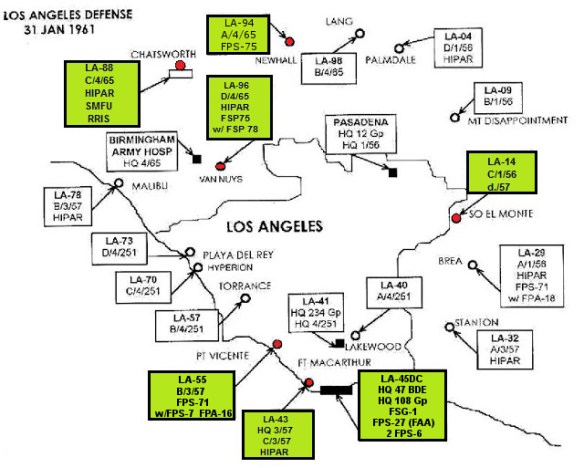
Did you know during the cold war that Los Angeles was surrounded by nuclear weapons? Or with the help of a newspaper, the city was mocked bombed by a squadron of planes? We even had the Soviet National Convention here!
Check out all this and more at the Cold War LA site. Cold War LA is a digital project that serves as an educational resource about the social, cultural, and political aspects of the Cold War era in Los Angeles for students, educators, veterans, and hobbyists. And yes there are a few maps too!
If you use ArcGIS Online, ESRI now has “Locator Views” in their geocoders. Basically you can specify what types of locations or only within a specific country or area you want to geocode against. For example, maybe you are just geocoding US addresses, not the whole world. Or maybe you just need to geocode to airport 3-letter codes. Whatever you need, you can customize your geosearching and geocoding experience. Click below for more info.

