If Shark Week has you wondering whether you should stay out of the water, a shark map may be just what you need. Check out this interactive map with animated shark tracks and commercial fishing activity on the East Coast.


If Shark Week has you wondering whether you should stay out of the water, a shark map may be just what you need. Check out this interactive map with animated shark tracks and commercial fishing activity on the East Coast.
ESRI blogged about their entire mid-year release of their software. To discover what’s new in ArcGIS Pro, ArcGIS Online, ArcGIS Enterprise, and their ArcGIS Apps, extensions, and developer tools, click here!
Between 1956 and 1974 those living in Los Angeles had little idea that they were surrounded by numerous nuclear warheads. 16 Nike missile sites as well as radar and control sites were established to defend the Los Angeles area, just in case Russia decided to send their bombers our way. Read about it and more on the Cold War LA website!

Here is a great example on how to use bivariate mapping and color hues to show two subjects that are compared in one map.

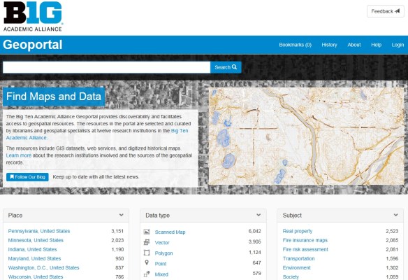
The Big Ten Academic Alliance Geoportal is a project that aims to make geospatial resources more discoverable and accessible to scholars. The Geoportal aggregates publicly-available geospatial resources, which are curated by librarians and specialists at twelve universities in the Big Ten Academic Alliance. These resources include GIS datasets, digitized historical maps, and web services, and each item is also accompanied by descriptive metadata along with links to download or view the full resource. They are easily searchable by both text and map and they can also be browsed by place, data type, and subject. The Geoportal’s resources include locations worldwide (including Antarctica), though their coverage is most extensive in the United States. It should be noted that this site does not itself host any data; instead, it serves as a one-stop shop that connects users to data hosted by numerous separate websites. Check it out!
For those of you that missed the ESRI User Conference last week, you can view the Plenary videos by clicking below.

They should have some of the workshop videos online soon.
The National Geospatial Advisory Committee (NGAC) held their summer meeting June 26-27, 2018 at the Department of the Interior, Washington, DC. The NGAC is a Federal Advisory Committee (FACA) to the Federal Geographic Data Committee (FGDC). The role of the NGAC is to provide advice and recommendations related to the national geospatial program and the development of the National Spatial Data Infrastructure. A summary of the meeting can be found here.
Rio Hondo College GIS courses start the week of August 18th. Registration is open for Fall GIS classes on campus and an Introductory course on location at the LA County Department of Public Works (900 S Fremont Ave, Alhambra). A new Geospatial Programming (Python) & Web Services class (GIS280) is also offered.
A list of GIS classes can be found here. Fees are $46/unit and some classes can be used to transfer to CSU and others. Steps for applying for admission and registering for the classes can be found here and can be performed entirely online with no fees. Applying for admission however should be done early to provide you the option to registering without delay as classes can fill quick.
Please contact Professor Warren Roberts at wroberts@riohondo.edu for inquiries about waivers needed for prerequisites and corequisites or any other info that you would like to ask.
The Plenary Session is live streaming now. Check it out!
UPDATE: View videos here.
The 2018 ESRI User Conference is here! For those of you that will be attending this week, I found a few sessions in the agenda that might be interesting:
ArcGIS Urban: An Introduction
8:30-9:30am Tues Room 16A | 1-2pm Thurs Room 17A
“Around the world, organizations use GIS to visualize the built environment, make smarter plans, engage stakeholders, and foster vibrant communities. Government leaders, partners, and citizens increasingly expect engaging online maps of their community that convey planning information in an easy to understand way. Attend this session for an overview of ArcGIS Urban, an upcoming initiative to transform how we orchestrate city development through web-based and desktop tools to make planning more creative and more productive.”
ArcGIS Indoors: An Introduction
8:30-9:30am Tues Room 14A | 4-5pm Tues Room 16B | 8:30-9:30am Wed Room 5A
“ArcGIS Indoors is Esri’s latest product offering and is a complete system that brings The Science of Where to indoor spaces. Join the ArcGIS Indoors team for an overview of how you can take the geographic approach to problem solving inside your buildings. We’ll cover how to assemble indoor data, add business value, and share it with web and mobile clients to support a wide range of workflows. This will be followed by a brief discussion on indoor positioning, complete with context of where it can and should add value.”
ArcGIS Monitor: An Introduction
10-11am Tues Room 14A | 4-5pm Tues Room 31B
“ArcGIS Enterprise administrators require effective monitoring solutions to meet the growing demand for feature-rich, highly available and performing ArcGIS solutions. In this session, learn how to configure the newly released ArcGIS Monitor product to diagnose the root causes of typical cases, e.g. performance, uptime and infrastructure problems.”
Arcade: An Introduction
10-11am Tues Room 5B | 4-5pm Tues Room 5B
“The ArcGIS platform is learning to express itself! GIS analysts use expressions all the time to calculate field values and define content for popups and labels, but until now, ArcGIS for Desktop has spoken a different expression language than other parts of the platform, such as ArcGIS Online. Introducing Arcade — a new way to write expressions that work across the ArcGIS Platform. In this session we will investigate what Arcade is (and what it isn’t), why it was created, and how to get started putting it to use in your projects.”
Drone2Map In Action
2:30-3:30pm Wed Room 29B
“Implementing a strategy for capturing aerial imagery from drones can transform the way organizations assess, plan, and manage their land holdings or project areas. This session presents two examples of how organizations developed drone usage policies, workflows, and processes for capturing imagery; and for products, such as image mosaics and Digital Surface Models, with Esri Drone2Map software.”
ArcGIS Pro: Authoring Content to ArcGIS Enterprise
2:30-3:30pm Tues Room 17B
“Transitioning from ArcMap to ArcGIS Pro includes changing your authoring workflow. This session will cover how to move from publishing GIS services from ArcMap to sharing content as layers from ArcGIS Pro. We will take a deep dive into the architecture that supports sharing and cover key concepts that differentiate authoring content in a modern GIS.”
See you at the conference!
