What is Arcade?

When I hear the word Arcade, I think of the days playing games like Pac-Man, Frogger, and Donkey Kong. However, this Arcade is used to customize ArcGIS apps.

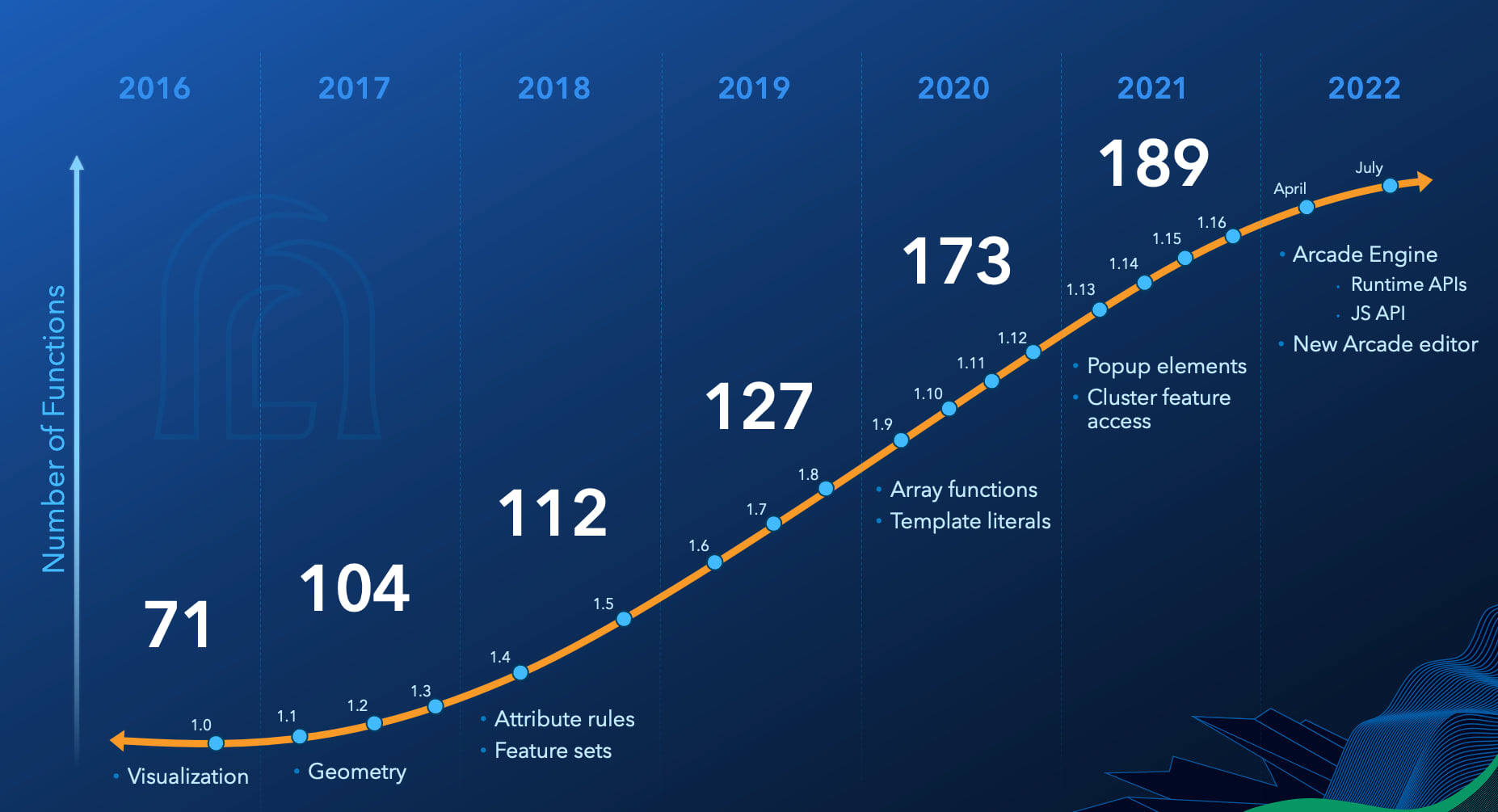
ArcGIS Arcade was first developed to be a calculator. It allows you to compute values derived from attributes in a layer. The result can be used in popups, labels and in renderers. Also the Arcade scripts work throughout the ArcGIS system. In the latest versions of Arcade, you can use it to customize popup content and define conditional behavior in forms and dashboard elements based on user input.

Click below to read more about Arcade and what you can do with it in your ArcGIS apps.

MXD – Set Data Sources

On occasion we have a need to change the data sources for the layers in our MXD files. Some MXDs have quite a few layers, so it would be a pain to go through each one in ArcMap and change them. This might happen to you when your source data is moved to let’s say a new enterprise geodatabase and now you have to update your MXD files.

If you have not done so before, try the Set Data Source(s) tool in ArcCatalog. Just navigate to where your MXD file is, then right click on it and select the Set Data Source(s) option:

The tool will open showing you the data frames and all the layers including their current data sources.

Continue reading

2020 Census Redistricting Data

It seems like we have been waiting forever for some 2020 Census Data. Well, you can get started with the P.L. 94-171 2020 Census Redistricting Data. It has been available since August 12. You can find the FAQ page for the product here. Keep in mind the redistricting data only includes demographic characteristics by state, county, city, down to the block level:

  • Race and ethnicity.
  • Population 18 years and over.
  • Occupied and vacant housing units.
  • People living in group quarters like nursing homes, prisons, military barracks and college dorms.

Note you will need to merge the data files with the tract/block group/block TIGER/Line Geodatabases. A feat that has become a little more difficult since you need to manipulate the data a bit to do it. You can read the technical document to find out more.

There is another option and probably an easier one.

Continue reading

Add Google Maps to ArcMap and Pro

So you want to add Google Maps to ArcMap or Pro? Impossible you say? Well here is an early Christmas present just for you … yes you can!

Before you proceed, think about why you would want a crowd sourced Google Maps basemap in your GIS anyway? There are better solutions today, like the basemaps provided by ESRI or even your own creations. For a government agency, replacing authoritative GIS data with crowd sourced data might not be a good idea.

Continue reading

Excel Not Working in ArcMap

Maybe you used to be able to open up Excel files in ArcCatalog and ArcMap, or maybe your new install will not open them.  You get this great message when you try to open Excel files:

Failed to connect to database. An underlying database error occurred. Class not registered

00n39000003ll24-0em39000000evaw

This happens when your IT group moves you to Microsoft Office 365 in the cloud, or you never had Microsoft Office on your computer.  ArcCatalog and ArcMap depend on certain Microsoft Office system drivers to be installed on your computer which allows you to open Excel files in your GIS.  Sure would be nice if the error message would tell you that!

Continue reading