
If you use QGIS version 3, you have the ability to add Google Maps layers to your map. The Google Maps layers are really Tile Map Services (TMS). The following is an example showing how to add Google Maps to QGIS.
Once you open a project in QGIS, in the Browser window to the left, scroll down to XYZ Tiles.

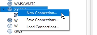
Right click on XYZ Tiles and choose New Connection.
In the XYZ Connection window, enter a name, like Google Maps, and then enter the URL “https://mt1.google.com/vt/lyrs=r&x={x}&y={y}&z={z}”. Also set the Max Zoom Level to 19.

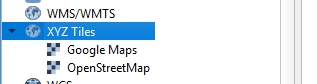
Click the OK button, and Google Maps is added to your XYZ Tiles list.
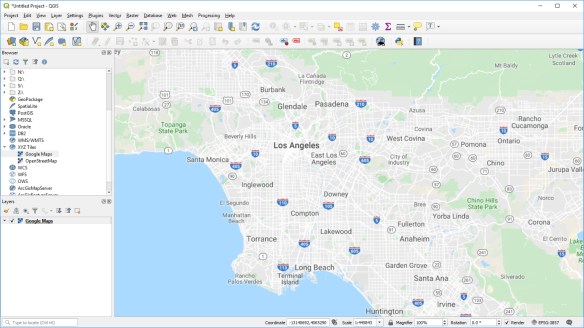
Now double click on Google Maps or drag & drop it and you will see it in your map area! Here I zoomed into the LA area.
If you prefer the satellite image or other images, here is a list of Google Maps layers that you can add to QGIS:
Google Maps: https://mt1.google.com/vt/lyrs=r&x={x}&y={y}&z={z}
Google Satellite: http://www.google.cn/maps/vt?lyrs=s@189&gl=cn&x={x}&y={y}&z={z}
Google Satellite Hybrid: https://mt1.google.com/vt/lyrs=y&x={x}&y={y}&z={z}
Google Terrain: https://mt1.google.com/vt/lyrs=p&x={x}&y={y}&z={z}
Google Roads: https://mt1.google.com/vt/lyrs=h&x={x}&y={y}&z={z}
Enjoy! -mike

How can you get QGIS to keep the same tile resolution/zoom so that when a map is exported as a JPG the labeling and fonts don’t go down to microscopic size?
I think I found something to make it work, but wish there was a better way. I set the Zoom minimum and maximum both to 11 in the XYZ connection options and I can now read the labeling on my exported JPG of a 1:250,000 scale 6.5″x6.5″ map.
It would be nice to know why the map appears one way in the Layout and looks different once saved. . . .
Hi Jeffrey. Glad you figured it out! -mike
How can I know which year the Google satellite layer is built.
Currently I am making map that needs to use the google satellite as the base map, but I would want to know is the link provided above the most recent updated?
Appreciated for your answer !!!
Hi Xi. This might help you out: https://www.labnol.org/internet/find-date-of-satellite-images/2964/ . Make sure Historical Imagery is turned on in the View pulldown menu at the top of Google Earth Pro.
Thank you for your answer, But I meant the year of the
Google Satellite: http://www.google.cn/maps/vt?lyrs=s@189&gl=cn&x={x}&y={y}&z={z}
which is provided above. I have added the connection to make my QGIS have this layer as a base. Since I need to list year of my data used in the map, I could not find information of the year.
I do have GOOGLE EARTH app on my desktop. Are they the same thing?
Yes, they both use the same source of imagery. Only Google Earth can show you the date.
is there any way to add google traffic map add as base map in qgis?
Good question. I do not know. -mike
I was able to get google traffic working with this URL
https://mt0.google.com/vt/lyrs=m@221097413,traffic&x=x&y=y&z=z
ArcGIS link please? 😀
See https://socalgis.org/2020/12/02/add-google-maps-to-arcmap-and-pro/ . -mike
I used the exact URL given here, and the Google Maps layer I got was in Chinese. How to set it so its in English?
This is the current URL that I use. I think the original worked for a while and then I had to search around and find something else. (???)
http://mt0.google.com/vt/lyrs=s&hl=en&x=x&y=y&z=z
Oops! You can skip the previous reply if it gets posted. I pasted the Google Satellite URL and then saw you were asking about the Maps one. I just checked and the URL I use is the same as the original.
Maybe it has something to do with where the Google server thinks you are. (???)
Hi do you have a recent URL for Google Satellite? the one you have above does not seem to work?! thanks Justine
Google satellite link working as of 9/7/2021
http://mt0.google.com/vt/lyrs=s&hl=en&x=x&y=y&z=z
Does anyone know if there’s a way to use the historical imagery that you can view in Google Earth in QGIS?
did you get the solution to set background of historical imagery in QGIS?
For some reason google satellite is not loading, any suggestions?
Hi there, does anybody know, how to improve the resolution of the wms in qgis? so that it is getting near to the resolution which is provided at the respective google websites?
Hi there, Google map tile(s) won’t fill in Openlayer
const baseMap = new Tile({ source: new OSM({ url: ‘https://mt{0-3}.google.com/vt/hl=en-US&lyrs=y&x={x}&y={y}&z={z}’, maxZoom: baseMapsData.maxzoom, }), });
Thank you. much Appreciated
The google map does not match open street map, it has ablout 1km distance from each other. How does it happen? Their coordinate systems are the same (Pseudo-Mercator)!
How can we get the latest Google Maps in QGIS
This URL currently works for me
https://mt1.google.com/vt/lyrs=m&x=x&y=y&z=z
Is it possible to load older Google Images like the ones available on the Google Earth?
It would be possible to go back in time and show not only the latest image.
Can it be done?
Thanks
Link to traffik map is not corect above. Use this:
https://mt0.google.com/vt/lyrs=m@221097413,traffic&x={x}&y={y}&z={z}
I want to display only traffic lines, not entire basemap. So I modify url as “https://mt0.google.com/vt/lyrs=traffic&x={x}&y={y}&z={z}“.
But the result is empty. How can I do?
I do not think you can modify anything, it’s just tiled images.
I’ve adjusted the zoom level and x-y coordinates so that the satellite imagery only shows North America (x=0, y=0, z=1). However, when I zoom in, the image replicates in a 2×2 grid (ie. there are 4 identical images). How do I fix it so that only 1 image remains, and I can zoom in and out freely?