Best Student Geologic Map Competition

The US Geological Survey (USGS) National Cooperative Geologic Mapping Program (NCGMP) in partnership with The Geological Society of America (GSA), GSA Foundation, Association of American State Geologists (AASG), American Geosciences Institute (AGI), American Institute of Professional Geologists (AIPG), and the Journal of Maps invites students to participate in the Best Student Geologic Map Competition.

This year marks the third annual Best Student Geologic Map Competition at the GSA Annual Meeting in Baltimore, Maryland. The competition will highlight student research from around the world that utilizes field mapping and the creation of geologic maps as a major component.

The top three student geologic maps will be selected for recognition and awards at a special judging session at the GSA Annual Meeting. Students will post their maps (Session Posters) on Tuesday, 3 November by 5:00 PM until 6:30 PM in the Poster Session area of the Exhibit Hall for review and evaluation by the judges. Maps may be placed in this area as early as 9 AM Tuesday, 3 November, but must be removed at 6:30 PM following the session. At the end of the session the top three maps will be selected and awarded.

Addressing The World With Three Words

Found this interesting startup which claims to have invented the “simplest way to communicate a location”.  The startup, what3words, divides the world up into 57 trillion 3×3 meter squares and then assigns each with three words that makes them unique.  With that, you now have a unique address for any location on the globe … even in the middle of nowhere!

what3words

From a human standpoint this makes sense.  We can remember three words for an address fairly easily, especially in a remote location that may not have an established address system.  However, gridding the world is not new.  We have many world grid systems, like MGRS that goes down to 1 meter squares.

Will what3words catch on?  Who knows.  Maybe if Amazon starts using it for deliveries by drone!  Start telling your friends to meet you at “humans.flash.crab” after work!

Become Part of the California GIS Council

Hi everyone,

I wanted to remind everyone to become a part of the CA GIS Council before our meeting next week at CalGIS (meeting details will follow tomorrow).  From the membership we will set up nominations and voting for membership of the executive committee.  We currently have 79 members of the council, which is a great start!

Registering is easy – since the council is voluntary, it’s a simple process – register on the council website and you are a member!!!

Here are some simple instructions:

  • Go to the council website: http://cgia.org/cagiscouncil
  • On the right side of the page, click on the Register link
  • Fill out the information, and click “Register”.  Make sure to select your constituency so that you can be included correctly.

You are in!!!

Mark Greninger
Geographic Information Officer
County of Los Angeles
mgreninger@cio.lacounty.gov

Interactive Snowpack Map

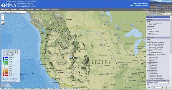
All along the Cascades and Sierra Nevada are ski courses that never opened, bare mountains and snowless SNOTEL sites where snowpack is measured. Where snow accumulated, it melted prematurely during a warm March. One of the most common questions for snow surveyors has been: how does this winter compare to the past?

A new, interactive map shows you exactly how it compares. The online map, just released by the USDA’s Natural Resources Conservation Service, shows regularly updated current conditions, alongside historical records, for the entire NRCS snow survey network.  Snowpack data in the new map is updated several times a day with edited information. Check it out!

snowpack

NACIS 2015 Student Map and Poster Competition

Greetings,

The North American Cartographic Information Society (NACIS) recognizes the important contributions students make to our field. To promote their hard work and achievements, we offer two fantastic student competitions each year at our annual conference (held this year on October 14–17 in Minneapolis, MN). All students currently enrolled in a certificate program, undergraduate, or graduate/post-graduate program are eligible to enter, as long as they have not previously won the top prize in either competition.

Student Dynamic Map Competition

NACIS recognizes the importance of dynamic mapping in cartography. We are sponsoring the 16th Annual Student Dynamic Map Competition to promote cartographic excellence and innovation in this versatile medium. Two prizes of $500 will be awarded; one for and individual project and one for a group project. Deadline for submissions is September 11th. To view the rules and prizes, please visit http://nacis.org/awards/student-dynamic-map-competition/.

Student Map and Poster Competition

Students who would like to display their works at NACIS 2015 should register for the Student Map and Poster Competition. There are two competition categories: cartographic design and research quality. We encourage all students to submit their maps and technical/research posters for a chance at one of two $500 prizes! There is no entry fee. All entrants will be displayed in the Exhibits Gallery, and the winner will be selected by a ballot of all meeting attendees. The deadline to register is September 11th, 2015. For more information, please visit http://nacis.org/awards/student-map-and-poster-competition/.

Please take a moment to encourage your students to enter either of the above competitions. We look forward to seeing the diverse range of entries in Minneapolis!

Travel Grants

As an organization (and as former students ourselves), we’re aware that student budgets don’t often allow for extras like conference attendance. Each year, NACIS offers a number of travel grants to students wishing to attend the annual conference. To find out more, please visit http://nacis.org/awards/grants/.

Thank you, and we hope to see you in Minneapolis in October!

Alethea Steingisser NACIS Board of Directors Chair – Awards and Travel Grants Committee

asteingi@uoregon.edu

California 3D Elevation Program (3DEP)

This is a reminder that public meetings will be held on May 26 at 1:00 PM PDT, and June 4 at 9:00 AM PDT to discuss potential high-resolution elevation data projects for federal fiscal year (FY) 2016.  The meetings are designed as a forum for all interested stakeholders in the California 3DEP community to discuss potential high-resolution elevation data project areas, identify common areas of mutual interest, and refine requirements.  The meetings will also cover general information about the Broad Agency Announcement (BAA) process for submitting 3DEP proposals for the FY 2016 program year.

Both in-person and virtual attendance is available for both meetings.  MEETING REGISTRATION is required.  Please visit this site to register: https://www.geoplatform.gov/elevation/3DEP/PublicMeetings/StateRegionalWorkshops

All meeting participants (both in-person and virtual) also have the option to provide details on their area of interest (AOI) and discuss their ideas.  Visit the link above to register; if you indicate you want to submit an AOI, the system will provide instructions on how to submit project information.  This should be done at least a week before the meeting.  [details on this process can also be seen here: https://www.geoplatform.gov/elevation/3DEP/Propose3DEPAOI]

The meetings are the next step in the BAA Public Meeting Series.  National meetings were held on April 24th and 29th to provide basic information about the national BAA process to the 3DEP stakeholder community.  Presentation materials from those meetings are available on the 3DEP Geospatial Platform Sharing Site: https://www.geoplatform.gov/elevation/3DEP/PublicMeetings

The next set of meetings are geographically focused.  Additional information on the two California meetings, and other state public meetings, can be found at the 3DEP Geospatial Platform Sharing Site noted above.  The May 26 meeting will be in San Diego and the June 4 meeting will be in Sacramento.  Meetings will be led by the USGS California National Map liaisons, Carol Ostergren and Drew Decker

Drew Decker
National Map Liaison for Pacific Region
U.S. Geological Survey
4165 Spruance Road, Suite 200
San Diego, CA 92101
619-225-6430
619-417-2879 cell
619-225-6101 fax
ddecker@usgs.gov
USNG 11S MS 8026 2158

Interactive Map of Murder Rates Around the World

Not a particularly fun topic, however, this interactive map of murder rates around the world uses a spinnable/clickable globe, graphs, and various widgets to get to the information you are interested in.  You can click on a country to see its murder count in a specific year, and for some countries the weapon most commonly used.  You can download the data too.

murderrates