An island in a lake on and island in a lake on an island … the Canadian Arctic Archipelago is home to the world’s largest third order island. Check it out!
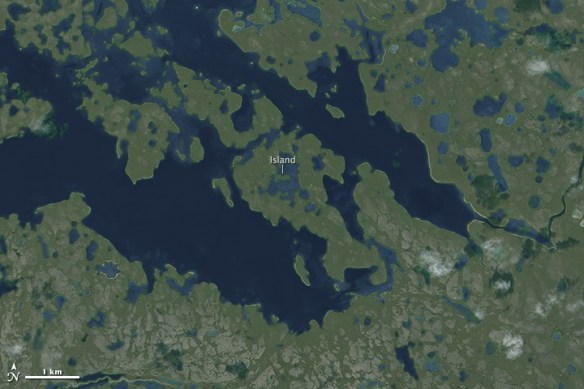

An island in a lake on and island in a lake on an island … the Canadian Arctic Archipelago is home to the world’s largest third order island. Check it out!
Here is an interesting article about using a drawing option in ArcMap called Match To Symbols. By naming a feature attribute with the same symbol name that is in a style, you can quickly symbolize them for feature categories. Click below to read.

This is just like when us old school GIS types used a field to store a symbol number to symbolize our points, lines, and polygons!
Here is an interesting article from the UK about how map reading seems to be a lost art. People have stopped being able to read maps in the age of automatic mapping … people are instead increasingly read by maps! Map reading should be a basic life skill and maybe we should start teaching it in schools again.

Today is GIS Day! If you are looking for a place to check out, may I suggest the GIS Day celebration at Los Angeles County. They put on a big show and have many booths and presentations.
You can find other places that are celebrating GIS Day by checking out the GIS Day map below.
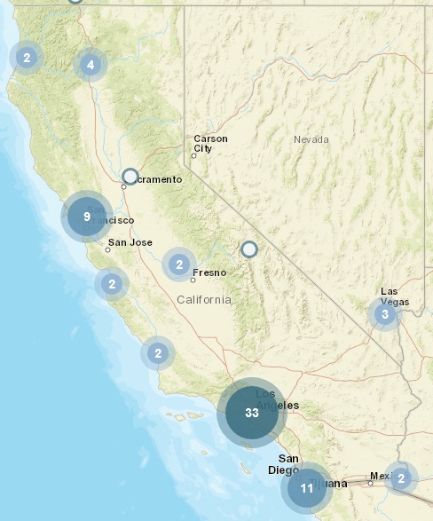
Happy GIS Day!
ESRI will be holding ArcGIS User Seminars where you will learn how to be more effective with ArcGIS and get a close look at what’s new in version 10.5. You’ll return to the office with practical tips and skills to use right away, including:
Register today to save your seat for the ArcGIS User Seminar.
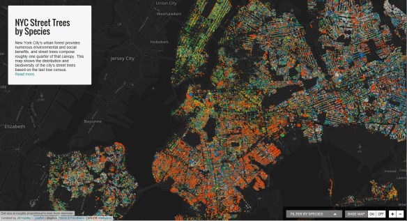
If you are a tree lover or interested in urban spaces, you will want to check out Jill Hubley’s interactive map of New York City Street Trees by Species. You can choose to zoom in on a particular neighborhood (or even block) to learn about the particular tree species in that area. Alternatively, you may conduct a search for a particular species to see where that species is distributed across the city.
The LA Times has an interactive map at the precinct level for Los Angeles, Orange, and other counties to see how others in your neighborhood voted. Check it out!

Mapping has been one of the most fertile areas of exploration for architecture and landscape in the past few decades. While documenting this shift in representation from the material and physical description toward the depiction of the unseen and often immaterial, Cartographic Grounds by Jill Desimini and Charles Waldheim takes a critical view toward the current use of data mapping and visualization and calls for a return to traditional cartographic techniques to reimagine the manifestation and manipulation of the ground itself. Continue reading
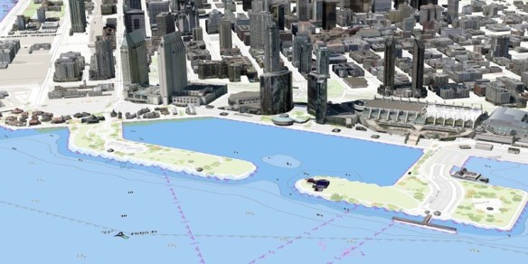
The Southern California Marine GIS User Group has announced it’s 2016 Fall Meeting hosted by the Port of San Diego. The Southern California Marine GIS is a welcoming group of GIS professionals and aficionados doing work in and about the Southern California marine and maritime community. Their goal is to create connections and foster innovation to improve and accelerate marine and maritime GIS in the local area. Click below for more info.