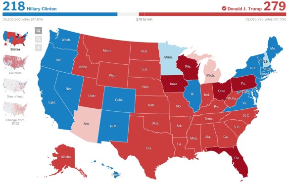
2016 Election Results Map Posted on November 9, 2016 by socalgovgis - Michael Carson Here is a good map showing right now the election results by state, county, size of lead, and change from 2012. Also, if you live in LA County, check out the state/county/local election results here. For Orange County, click here. Share this: Share on X (Opens in new window) X Share on Facebook (Opens in new window) Facebook Share on Tumblr (Opens in new window) Tumblr Share on LinkedIn (Opens in new window) LinkedIn Email a link to a friend (Opens in new window) Email Print (Opens in new window) Print Like Loading... Related
Hey … did you see the cartogram?? https://www.washingtonpost.com/graphics/politics/2016-election/how-election-maps-lie/ DIANA McCARTHY GIS Specialist | Community Development Department City of Fullerton | 303 W. Commonwealth Ave. | Fullerton CA 92832 714.738.6561 voice | 714.738.3110 fax DianaM@ci.fullerton.ca.us | http://www.ci.fullerton.ca.us Reply ↓


Hey … did you see the cartogram??
https://www.washingtonpost.com/graphics/politics/2016-election/how-election-maps-lie/
DIANA McCARTHY
GIS Specialist | Community Development Department
City of Fullerton | 303 W. Commonwealth Ave. | Fullerton CA 92832
714.738.6561 voice | 714.738.3110 fax
DianaM@ci.fullerton.ca.us | http://www.ci.fullerton.ca.us
Cool!