Right-of-Way GIS

If you deal with projects in the right-of-way, why not use GIS to manage them? GIS can improve project planning by delivering integrated project and basemap data and information to all stakeholders.  GIS adds new ways to collect, organize and manage ownership records, deeds, surveys, projects plans and more.  GIS enables high accuracy data collection reducing visits to the field.  GIS reduces costs, improves public engagement, and increases project efficiencies.  GIS delivers a framework for better decision making.

It’s a miracle right? All kidding aside, check out these ArcGIS solutions to map and monitor your roads and highways.

Permanent Daylight Savings Time

Well, they did it. The US Senate passed a bill this week to make DST permanent by November 2023, except for states that do not observe DST … good for you Arizona and Hawaii!

The bill now has to pass in the House. If it does, enjoy the darkness in the winter months if you live near the western portion of your time zone! Here is a nice quote:

“Not many people have experienced daylight saving time during the winter, except for some during an experiment — which failed.”

Click the map below to read all about it. Check out the nice maps too!

Thanks goes to Bonnie at Manhattan Beach for finding this article!

One-Year MS in GIS @ CSULB

One-Year MS in GIS @ CSULB – Apply Now for Fall 2022!

Geospatial is everywhere. Develop your geospatial skills through a Master of Science in Geographic Information Science (MSGISci) at California State University Long Beach (CSULB).

The MSGISci is a 1-year, 30-unit MS degree program offered through the Department of Geography. Classes are scheduled on weeknights and weekends to accommodate working professionals. Please visit http://www.beachgis.com for program details, application instructions, and to sign up for an upcoming information session. Join our network of over 100 program graduates by summer 2023!

Applications will be reviewed on a rolling basis and will be accepted until June 1st for domestic applicants and April 1st for international students.

ArcGIS Online Organization Home Page

If you have an ArcGIS Online for Organizations account, ESRI will be pushing out an update that will change your home page. If you do not switch to the new home page or request an extension (good to September 2022), your old (legacy) home page will be automatically replaced with a default home page at the next ArcGIS Online update, planned for March 22, 2022. To ensure that your home page looks and performs as desired, transition to the new home page before the legacy home page is automatically replaced. Organizations that do not use the ArcGIS Online home page as a landing page will be automatically transitioned to the default home page. No further action is required.

For more information and how to change your home page with the new editor, click below.

ArcGIS Online Update March 22

ESRI will be updating ArcGIS Online on March 22, 5pm to midnight (PDT).

Update Highlights

Mapping

  • Editing enhancements including snapping controls and additional capabilities in the editor pane
  • Ability to duplicate feature layers in Map Viewer to customize the configuration of a layer without affecting the configuration of the source layer
  • New nested group capability, simplifying visualization and review of complex data

Content and Member Management

  • Administrators can allow members to transfer their own content to other members of the organization. 
  • Administrators can set up member categories to make it easy for the organization’s members to find each other by searching characteristics such as department or project.

Interact with Maps and Data Using ArcGIS Instant Apps

  • Exhibit, a new app template, follows a sequential order as it guides your audience through a map and tells a story with interactive slides.
  • Portfolio includes two new layouts for additional flexibility as you build one app to showcase maps, apps, and web pages about a topic or location. 
  • Attachment Viewer allows viewers to update the attribute information of the attached images or videos while navigating through each feature.

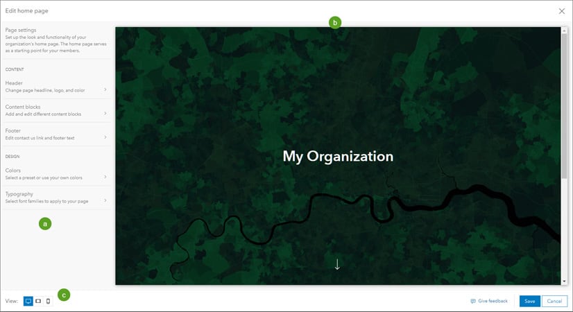
Home Page Replacement

Legacy ArcGIS Online home pages will automatically be replaced with a new default home page unless the administrator requests an extension through the Organization page. Transition to the new home page to ensure that your home page looks and performs as desired.

Early Adopter Community

Would you like to try the features planned for the upcoming ArcGIS Online update? Sign up for the ArcGIS Online Early Adopter Community (EAC) with your ArcGIS Online login. Within the ArcGIS Online testing environment, EAC members can try upcoming features, test compatibility with their existing workflows, influence product development, and engage with the ArcGIS Online development team and other members of the EAC.