Wishing everyone a very Merry Christmas and a Happy New Year. Enjoy this year’s Christmas Card Map! -mike

If you are looking for last minute gifts for that mapper type, check out National Geographic’s site!
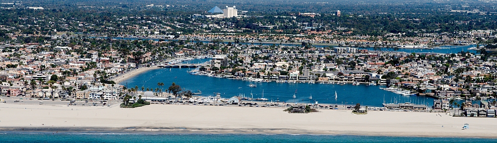
Wishing everyone a very Merry Christmas and a Happy New Year. Enjoy this year’s Christmas Card Map! -mike
If you are looking for last minute gifts for that mapper type, check out National Geographic’s site!
Goodbye Oracle, hello PostgreSQL! I’ve decided to get out of the Oracle business and move our Enterprise Geodatabase to PostgreSQL. I’m tired of giving Oracle lots of money each year. PostgreSQL is open source and it is very mature. Though we do not have a dedicated DBA here that knows PostgreSQL, they can learn! And so can I. Besides, ESRI supports it and if something goes wrong, I can get them on the red hotline phone!
Over the past few years, I have been testing PostgreSQL on Windows by installing it with our ArcGIS Server installations and using it to store GIS data used in our map and feature services. I have had only one issue and it was a speed problem when selecting over 10,000 polygons in ArcMap. ESRI confirmed it was a bug. I believe that problem has gone away, so now is a good time to move to PostgreSQL. But just to be sure, we will be running both Oracle and PostgreSQL in parallel for a few months.
NOTE: To be able to install an Enterprise Geodatabase in PostgreSQL, you must be running ArcGIS Server (enterprise addition) somewhere. You need the keycodes file that was created with it to authorize the geodatabase. You will also need the st_geometry.so file that was created when you installed ArcGIS Desktop 10.6. More on that later. Continue reading
Two years ago I mentioned James Niehues and his ski resort maps that he had made over the years. Now there is a Kickstarter campaign to create a hardcover coffee table book and art print series of his work. Check it out!

Have a few minutes to spare before your next task? Open Google Maps and turn on the satellite imagery. Now zoom all the way out until you see Earth and listed on the left are planets, moons, and other objects you can zoom to and check out. See you in an hour!

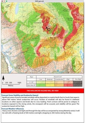
SoCal does not experience avalanches very often. Since 1950, at least 64 people have died in avalanches in California with 9 of those in SoCal, according to this article.
Snow avalanches can cause a significant loss of life. As a naturally occurring disaster they are unique in nature, usually being highly localized events, and often in remote areas. Their victims are often voluntarily at risk for recreation purposes and become the trigger of their own avalanche.
Avalanche forecasting seeks to safeguard recreationists in winter mountain environments using risk based decision making. Avalanche experts interpret the spatial and temporal distribution of hazards and abstractly present these in the form of a forecast. Recreationists can then use them for planning excursions into avalanche prone terrain and avoid high risk slopes that pose a hazard.
Check out this article on how Scotland looked at using GIS to make cartographic visualizations of predicted avalanche danger areas.
Sir Francis Galton was the first to identify the anticyclone (as opposed to the cyclone), and introduced the use of charts showing areas of similar air pressure – the modern weather map. His book Meteorographica was the first systematic attempt to gather, chart and interpret weather data on a continental scale, a fundamental work of modern scientific meteorology.
Galton prepared the first weather map published in the British newspaper The Times (April 1 1875, showing the weather from the previous day, March 31), now a standard feature in newspapers worldwide. Click below to read more about Sir Francis Galton.

Standing out on the shoreline, have you ever wondered if you set sail straight ahead across the sea what other beach would you run into? Check out the Beyond The Sea interactive map. You can move your mouse along a shoreline or click on a country to visualize all the locations which lie directly across the sea. Location names will be displayed once the track hits land. Colors of the lines represent the different destination continents. Try the Start Fireworks button too for an impressive display!

ESRI has opened up the registration for the 2019 ESRI User Conference in San Diego. Register now and get your favorite hotel while they last!
PS – Most of the government rates have been taken at the closer hotels already! 😦
Starting the night of December 5th, ESRI will be changing the user types in ArcGIS Online. Right now there is a Level 1 and Level 2 user, where Level 1 was a viewer only and Level 2 could publish and edit data. After the change there will be 5 user types: Viewer (formally Level 1), Editor, Field Worker, Creator (formally Level 2), and GIS Professional.
The new user types include a mix of capabilities and included applications. For example, the Field Worker user type includes the ability to edit existing datasets through field apps like Survey123, Workforce, and Collector. The different functions of each user type can be found here. Read the ESRI blog about the new user types here.
ESRI states your current user settings will not change … I would check that after December 5th! Role settings will not change.
Looking for that interesting map book or atlas for the cartographic nut in your family? Or maybe for you! Check out this listing of map books that were published or are scheduled to be published in 2018, with a few in 2019.

