July 4th is almost here, and that means fireworks again! The fireworks app that has been used in the past few years has been updated, adding cities in San Bernardino County. Continue reading
Fireworks 2018!
2
July 4th is almost here, and that means fireworks again! The fireworks app that has been used in the past few years has been updated, adding cities in San Bernardino County. Continue reading
At the 2018 ESRI User Conference on July 9th, the Plenary session will be live streamed on the internet from 8:30am to 3:30pm PDT. So if you cannot make the conference, you can at least check out the Plenary session. Recorded videos will also be available online afterward.

UPDATE: View videos here.
ESRI and DigitalGlobe have created a story map that visualizes the 12 stadiums being used for FIFA World Cup 2018 in Russia. The World Cup is a major sports draw every 4 years, with over 3.2 billion people watching. Even more remarkable is that this is the first time the event has taken place in Russia. Check it out!

Looking for a gift for someone who loves maps? Take a look at The Phantom Atlas. Long before satellites and Google, cartographers traced out maps of the world, some with errors that persisted for hundreds of years. The Phantom Atlas compiles the greatest “myths, lies and blunders” on maps, from honest mistakes to deliberate lies. Check out this interview with the author:
Hardcover and Kindle versions available on Amazon:

The 2018 ESRI User Conference in San Diego is rapidly approaching. Is your government agency sending you to the conference this year? Why not attend the State and Local Government Social at the Hilton on Wednesday, July 11 from 6-8pm? Hope to see you there!
This one made me laugh!
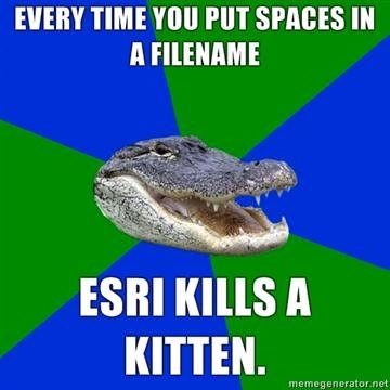
Spaces in file names were a big problem with my GIS students.
Just found this interesting article about why you want the highest resolution imagery possible for your projects. Check it out.
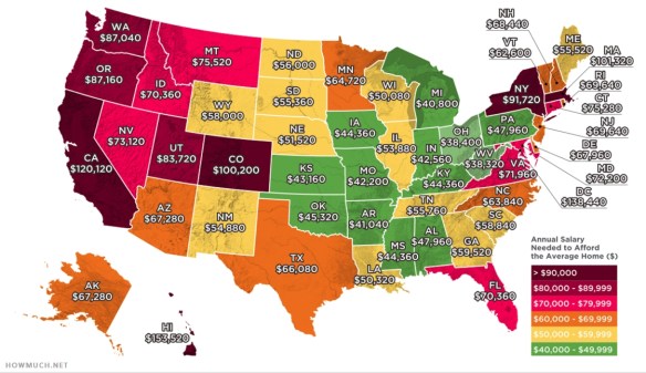
Looking to buy a home in California? You will need to make $120,120 per year to afford an average home. Check out this article and map of the US showing what your annual salary must be to afford an average home.
Interesting article on mapping and assessing landscape suitability for bee migration. GIS and remote-sensing applications can help to assess and map landscape as well as beekeeping suitability to allow precision beekeeping and hence the promotion of colonies. Check it out!

ESRI is hosting a webinar series dedicated to the trends, technical advancements, best practices, and special topics relating to GIS in public safety. Each webinar highlights a different subject relevant to your organization’s missions, workflows, and operations. Upcoming webinars include the following:
Visit the ESRI Public Safety Webinar Series website to register for upcoming events and stay up to date with GIS solutions for public safety agencies.