Rare Total Lunar Eclipse Tomorrow

There will be a rare total lunar eclipse tomorrow … well not that the eclipse is rare, but it will be happening at the same time as the blue moon and supermoon, an event that has not happened in over 150 years.

In the LA area, you will need to get up early to see it.  The full eclipse begins 4:51am with the maximum at 5:29am:

lunareclipseinfo

148_lunar_eclipse_2018

Continue reading

CNPS Conservation Conference 2018

The CNPS Conservation Conference will be held next week at the Los Angeles Airport Marriott, February 1-3.  This conference only takes place every 3 years, so it is a big event when it happens.

ESRI is donating two ArcGIS Pro packages to be auctioned off.  You can find the auction (plus others) at the conference’s auctions page.  You can also have a chance to name a newly discovered rate plant!  Click below to check out the conference and sign up.

cnps_2018-logo_dates-620

NorCal URISA Public Forum on NAIP

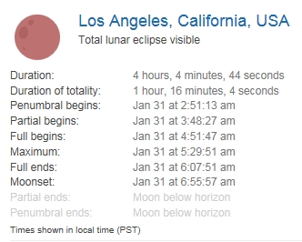
Reduced funding from federal partners are causing the USDA Farm Service Agency to explore funding and licensing options for NAIP. NorCal URISA is holding a public forum to have a conversation across the community about NAIP and perhaps bring more use cases and needs forward that might otherwise go unaided. A representative from USDA is planning on attending this meeting and giving a short overview, after that there will be an open discussion about use cases for how you have been using NAIP. Your use cases will be assembled for our friends at the USDA and Save the NAIP so that they can have more examples about the far-reaching benefits of this valuable dataset.

The in-person meeting will be held on January 25th, 2018, from 2pm to 4:30pm PST at: West Sacramento Galleria – 1110 West Capitol Ave, West Sacramento, CA 95691.

There will also be an online webinar for the meeting as well. Please register in advance if interested.

A Case for Open-Source GIS

Interesting article about moving from ArcGIS to open-source GIS, though be aware in the end this consultant is trying to sell you training.  I would disagree with the author’s statement:

Many people who come from an ESRI-centric GIS education tend to think that ESRI is the standard because it is the most popular commercial GIS software, but in fact the opposite is true. Most open source GIS software will yield the same results because they implement the same SFS geometry model and the same GEOS vector functions. But ESRI software may not, because it uses its own proprietary geometry model and its own proprietary spatial functions.

He does go on the say ESRI’s software has been around a long time and stood the test of time.  I would argue that Continue reading

Nike Manufacturing Map

Many companies are becoming more open about how and where their products are manufactured. The Nike Manufacturing Map is an interactive map which shows the location of independent factories contracted to make Nike products. The map also allows you to access information about the product made by each factory and data about the employees.  Continue reading

Atlas of Historical County Boundaries

Wondering how the boundary of Los Angeles County looked like in 1851?  Here you go:

lacobndry1

Here it is in 1887, just before Orange County was created the year after:

lacobndry2

The Atlas of Historical County Boundaries allows you to explore how county boundaries have shifted throughout history.  You can also download GIS shapefiles of polygons for each different configuration of a state’s counties or the entire United States, coded by date.  Check it out!

lacobndry3

CGS Seismic Hazards Program Update

The California Geologic Survey (CGS) Seismic Hazards Program has significantly updated two versions of its regulatory hazard zone map products. First, all GIS data files (in ESRI Shapefile format) for fault rupture, liquefaction and earthquake-induced landslide zones have been re-projected to California (Teale) Albers, in meters, with a North American Datum 1983. In addition, all GIS zone polygons now include attributes that provide the name of the 7.5-minute quadrangle, map release date(s), and links to zone reports and PDF maps. Active fault traces within earthquake fault zones have attributes for fault name and fault type. Continue reading