July 4th will be here soon and that means Fireworks! The fireworks app I have used for the past few years has been updated. It includes the cities in LA, Orange, Ventura, and Riverside County. If you love fireworks and want to find out where you can legally buy and shoot them off in SoCal, check out the app!
Monthly Archives: June 2017
Local GIS Jobs This Week
Regional Conservation Authority Chief – Riverside County
Architectural Historian – Edwards AFB
GIS Analyst – Los Angeles area
Intern – Los Angeles area
Bring LARIAC5 Early Access Imagery into ArcGIS Desktop
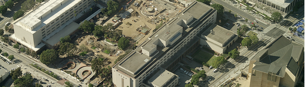
If your organization participates in LARIAC, then you probably know that right now you have Early Access to the 2017 imagery (both orthos and obliques) in Pictometry’s online CONNECTExplorer application. Keep in mind the Early Access imagery still has work to be done on it, but at least you can take a look at the new stuff while they are working on it.
One thing you can do is bring some of the ortho imagery into your ArcGIS Desktop environment. Here are the simple steps to do so:
- Login to ConnectExplorer and zoom to the area you are interested in. Make sure to set the imagery date to “Early Access”.
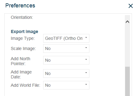
- Next, set your Export Image preferences to output a GeoTIFF and turn off scale image, north pointer, and image date if you want. You do not need a world file for a GeoTIFF.
- Next, bring up the ortho view of the area you want. Make sure to zoom in quite a bit to get the higher resolution.
- In the lower-right corner, click on the export icon and select Export Entire Image.
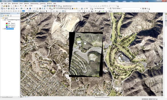
- Now bring the GeoTIFF into ArcGIS Desktop. Here I have the new 2017 ortho displayed on top of the 2014 ortho.
- Your image might look a little choppy. To fix that, open the layer properties, select the Display tab, and change the “Resample during display” setting to “Bilinear Interpolation”. The “Nearest Neighbor” setting will make your image too choppy looking. Bilinear does a great job smoothing it out.
The GeoTIFF images are actually using geographic coordinates (WGS84), but they reproject very well into State Plane.
This is a very quick way to bring in the new 2017 Early Access imagery into your maps if you need to. As the imagery is cleaned up and worked on to create preliminary images, there will be map services setup for you to consume in your applications. But for now, you can use these steps. Enjoy! -mike
Seeking Antique Map Expert
Seeking antique map expert for TV project on treasure hunting. Please contact Trey at trey@karga7.com. More info about the production company here.
Resource Analyst/GIS Position
The Colorado Desert District of California State Parks is looking for a Resource Analyst/GIS specialist. The following links will take you to the exam page for CAL human resources and the job description for the position.
Job Description: https://jobs.ca.gov/JOBSGEN/PB064.PDF
To Apply: https://jobs.ca.gov/CalHrPublic/Jobs/JobPosting.aspx?JobControlId=65890
The Billion Dollar War Over Maps
Local GIS Jobs This Week
Business Systems GIS Analyst III – San Bernardino County
GIS Analyst Transportation Planner – Ventura County
GIS Analyst – Anaheim area
Utility Forester/Work Planner – Palmdale area
ArcGIS for Local Government UC 2017
Today there will be a meetup, June 22nd at 11am (PDT), about what’s coming in the ArcGIS for Local Government UC 2017 release as well as ArcGIS for Local Government events at the ESRI User Conference in July. If you are interested, please join the meetup today by registering here.
After registering, you will receive a confirmation email containing information about joining the webinar.
2017 Geospatial Summit Videos and Presentations
USGS Requesting Information
The USGS is requesting information from the land imaging community for user requirements for future Landsat systems. To view the RFI go to www.fedconnect.net, click on “Search Public Opportunities Only”, then choose search by “Reference Number” which is G17PS00634. Click on right side of the screen to view the RFI document. An overview:
This is a Request for Information – User Needs for Future Landsat Missions. The U.S. Geological Survey (USGS) Land Remote Sensing Program has collected a diverse set of U.S. Federal civil user measurement needs for moderate-resolution land imaging to help formulate future Landsat missions. The primary objective of this RFI is to determine if these needs are representative of the broader Landsat user community, including, but not limited to, private sector, government agencies, non-governmental organizations and academia, both domestic and foreign. Responses to this RFI will be considered along with other inputs in future system formulation. Please see the RFI for full details.
Please pass along to your land imaging constituents this information. Any inquiries about the RFI can be sent to the Contracting Officer, Vickie Floyd (vfloyd@usgs.gov), during the open RFI period. Responses are due no later than 11:00 am ET, July 14, 2017.