ESRI has released ArcGIS Pro 2.7. Watch the video below about what’s new.
What’s New documentation here.
If your software maintenance is up to date, you can download from https://my.esri.com .

ESRI has released ArcGIS Pro 2.7. Watch the video below about what’s new.
What’s New documentation here.
If your software maintenance is up to date, you can download from https://my.esri.com .
Before I take off for the rest of the year, I would like to wish everyone a very Merry Christmas and a Happy New Year. Enjoy this year’s Christmas Map! -mike
Depending on where you live, here is the historic probability of at least 1 inch of snow on Christmas. Spoiler alert, Los Angeles is 0%.

More info about the map here.
Looks like ESRI has released the prerelease of ArcGIS Enterprise 10.9. You can download your software at my.esri.com.
Other info about this prerelease:
ArcGIS Enterprise 10.9 upgrades are not supported at the 10.9 prerelease. To see the new capabilities of the ArcGIS Enterprise 10.9 prerelease, a new installation is required. Upgrades from previous versions to the 10.9 prerelease are supported only for testing purposes. Do not upgrade production systems to the 10.9 prerelease. Upgrades from the prerelease version to the final released version are not supported. The final release of 10.9 will support upgrades from previous software releases as usual.
The following components are not included with the ArcGIS Enterprise 10.9 prerelease and will be available with the final release of ArcGIS Enterprise 10.9:
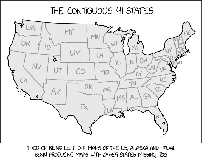
At first glance, everything looks ok. Do you know which of the 7 are missing? Brought to you by xkcd.com.
Get into the Holiday spirit and make a Cassini globe ornament. Check out the ESRI blog post below.

Received an email from ESRI a few days ago about them updating ArcGIS Online on December 8, from 5 pm-midnight PST. This update will include new features and enhancements that improve security policies and administrative capabilities, including HTTPS enforcement, end of support for Internet Explorer 11 and Microsoft Edge Legacy, managing the organization’s access to apps, adding a new Asia-Pacific region for new organization subscriptions, and new charts for monitoring Data Store usage.
More details below:
| HTTPS Enforcement ArcGIS Online will enforce the use of HTTPS on the night of the update. This change has been communicated over the past year, and the December update will enforce the policy across all of ArcGIS Online. The enforcement of HTTPS ensures that all data is encrypted, confidentiality is improved, and sensitive data is secure. For more information about how to prepare for this change and potential impacts, please read the following article. |
| End of ESRI Support for Internet Explorer 11 In accordance with Microsoft’s official retirement of Internet Explorer 11 and Edge Legacy, both Internet Explorer 11 and Edge Legacy have been deprecated with ArcGIS Online. With the December update of ArcGIS Online, customers will no longer be able to receive support with issues related to Internet Explorer 11 or Microsoft Edge Legacy. We recommend using the latest version of Google Chrome, Mozilla Firefox, Apple Safari, or Microsoft Edge in order to avoid any performance issues. Starting with the December 2020 update, any users that use IE11 or Edge Legacy to view ArcGIS Online applications or the website will receive an information message indicating the usage of an unsupported browser. |
| Manage Organization Access to Included Apps To enable organizations to comply with policies such as FedRAMP, and to have more control over which apps their organization members can use, administrators will have the ability to block access to included ESRI applications. Administrators can choose to block apps that are included with all user types and cannot be controlled through licenses, settings, or privileges. |
| New Asia-Pacific Region for Hosted Data An Asia-Pacific region will be introduced as an option for any new ArcGIS Online subscriptions. This region will provide a new location for hosting data in addition to the existing US and European regions. Please read this article for the details of how data hosting works with our regions. |
| New Usage Chart for Feature Data Store A new chart, available to administrators through the Organization tab, will provide more insight into the feature data store that powers hosted feature layers. All administrators will be able to quickly view the current usage of the organization’s allotted storage. For organizations that have purchased a Premium Feature Data Store subscription, a new chart will be available that displays the utilization of the resources over-time. |
So you want to add Google Maps to ArcMap or Pro? Impossible you say? Well here is an early Christmas present just for you … yes you can!
Before you proceed, think about why you would want a crowd sourced Google Maps basemap in your GIS anyway? There are better solutions today, like the basemaps provided by ESRI or even your own creations. For a government agency, replacing authoritative GIS data with crowd sourced data might not be a good idea.
Continue readingThis FREE crash course (tutorial) will teach you a basic understanding of how to use and interpret historical aerial photographs (air photos).
This tutorial is designed to be used by adults including undergraduate students. The tutorial is a serious endeavor created to teach you something; it is not a site for pretty pictures.
The tutorial is broken into 2 parts — introductory text and quizzes. The introductory text can be completed in approximately 30 minutes. The quizzes are skill-building exercises and can be completed in 30 to 45 minutes.
In this tutorial you will learn:
Start learning about air photos! https://mines.libwizard.com/f/airphotos_2
Think you already know a lot about aerial photographs?
Go directly to the quizzes! https://mines.libwizard.com/f/airphotos_2/p/21
