2015 ESRI User Conference Plenary

For those of you that arrived in San Diego on Sunday, you were greeted by a downpour of rain that lasted into the night. However, that all cleared up today for the 36th Annual ESRI User Conference.

esriuc2015

During this morning’s Plenary Session, Jack emphasized the “Geography Everywhere” theme and touched on the usual things like web GIS and sharing data. Really there were few surprises. However, they did have a cute little skit about all their apps, posing like individuals in a dating service to get your attention to use them. It was a different way of showing you all the choices you have when it came to apps.  You can even vote for your favorite app here.

Here are a few new announcements that might be of interest:

  1. Vector tiles, finally!
  2. New Workforce/Dispatcher, Workforce/Mobile, and Navigator apps that will work with Collector
  3. New AppStudio for ArcGIS that will help you build your own native apps in Android, iOS, Windows, and Linux
  4. ArcGIS Earth, full KML file support
  5. New drone app
  6. Statistical and scientific packages like R and SciPy will be able to run directly as geoprocessing tools/scripts in ArcGIS
  7. ArcGIS for home use licensing will now extend to the entire ArcGIS product, not just Desktop
  8. Expect ArcGIS 10.4 and Pro 1.2 in Winter 2016

I would suspect that ESRI will have the Plenary Session video online sometime today. I will update this post when it becomes available for you to watch at home! -mike

4:25pm update:  Click here for today’s videos.

New Release of ArcGIS Pro

This week ESRI has released ArcGIS Pro 1.1.  Here is a list of some of the enhancements:

  • A new SDK for .NET to customize and extend ArcGIS Pro
  • A Range Slider that allows you to dissect and visually analyze your numeric data
  • The ability to publish 3D scenes containing multipatches
  • Layout enhancements, like guides and snapping and the ability to add extent indicators
  • Support for working with Excel tables directly
  • Date line wrapping allowing you to pan, edit, and work across the international date line

Click below to read more about the release.

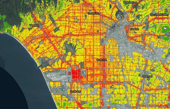
What is your Soundscore? Mapping Noise

Here is a new startup, Howloud, taking on the challenge of calculating and mapping residential noise levels.  If you live in LA or Orange Counties, enter your address to see your Soundscore.

la_soundscores2

Also, here is a KCAL 9 news piece about Howloud, and a LA Curbed article.

I noticed that the areas of Santa Clarita, Lancaster and Palmdale have not been calculated yet.  Donate to their Kickstarter to get them done!  Their plans are to build a sound map for North America, including mapping noise around buildings in 3D.

Fireworks 2015: Cities Added!

July 4th is just around the corner and that means Fireworks!  Once again I bring you the fireworks app.  You can view cities in LA, Orange, and Ventura County that allow the sale and use of fireworks.  Included are days and times when fireworks will be sold and when you can light them up, as well as links to city web sites and telephone numbers.  Data was collected from municipal codes, web sites, and/or contacting each city.

This year the City of Anaheim and the City of Huntington Beach have been added to the map.  Through measures last year, voters decided to allow fireworks to be sold and used within their borders.  Congratulations to them and enjoy the app!

fireworksapp2015

USGS Webinar: Using the National Map Services

Are you a developer, firm, or organization using mobile or web applications to enable your users?  The USGS has publicly available geospatial services and data to help your application development and enhancement.

The USGS National Geospatial Technical Operations Center will be hosting a 30- minute webinar on “Using The National Map services to enable your web and mobile mapping efforts” on June 16 at 9am Mountain Time.

Best Student Geologic Map Competition

The US Geological Survey (USGS) National Cooperative Geologic Mapping Program (NCGMP) in partnership with The Geological Society of America (GSA), GSA Foundation, Association of American State Geologists (AASG), American Geosciences Institute (AGI), American Institute of Professional Geologists (AIPG), and the Journal of Maps invites students to participate in the Best Student Geologic Map Competition.

This year marks the third annual Best Student Geologic Map Competition at the GSA Annual Meeting in Baltimore, Maryland. The competition will highlight student research from around the world that utilizes field mapping and the creation of geologic maps as a major component.

The top three student geologic maps will be selected for recognition and awards at a special judging session at the GSA Annual Meeting. Students will post their maps (Session Posters) on Tuesday, 3 November by 5:00 PM until 6:30 PM in the Poster Session area of the Exhibit Hall for review and evaluation by the judges. Maps may be placed in this area as early as 9 AM Tuesday, 3 November, but must be removed at 6:30 PM following the session. At the end of the session the top three maps will be selected and awarded.