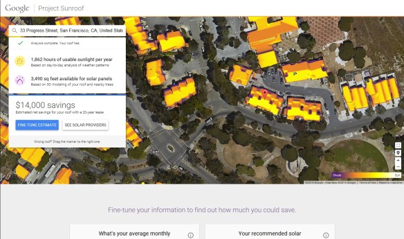
Looks like Google is starting to calculate solar information on their building data. They started Project Sunroof to make installing solar panels easy and understandable for anyone by calculating the best solar plan.
Does that sound familiar? It should since LA County has done that already with their Solar Map.
When you enter an address, Project Sunroof looks up the address in Google Maps and combines the map data with other databases to create a personalized roof analysis. They compute how much sunlight hits your roof using their 3D building models, shadows cast by nearby structures and trees, sun positions over the year, and historical cloud and temp patterns. They then recommend an installation size for your roof and reference local solar providers.
Currently Project Sunroof only covers Boston where the Sunroof Team is, the San Francisco Bay area where Google is, and Fresno … where one of the engineer’s mom lives.
Once they figure out the LA area, it will be interesting to compare it to LA County’s Solar Map information.
Take a look at the short video and visit the Project Sunroof website for more info.

We will reach out to see if we can stream therr API to a 3D Solar map we are developing to demonstrate to the City of Santa Monica
Checked out their data in San Francisco – they don’t distinguish buildings well enough – that was a big surprise. I think it’s pretty suspect.
Have you got a app for South African