The Program
During the cold war, there was a spy satellite program called Corona. The Corona program was a series of American strategic reconnaissance satellites produced and operated by the Central Intelligence Agency Directorate of Science & Technology with substantial assistance from the US Air Force. The Corona satellites were used for photographic surveillance of the Soviet Union (USSR), the People’s Republic of China, and other areas beginning in June 1959 and ending in May 1972. The name “Corona” was a code name, not an acronym.
The Technology Behind the Photos
During the program, there were 144 satellites launched, of which 102 returned usable photographs. The satellites orbited at altitudes of 100 miles above the Earth, with later missions orbiting even lower at 75 miles.

The satellites used special 70mm film with a 24 inch focal length camera manufactured by Eastman Kodak. The film was 0.0003 inches thick, with a resolution of 170 lines per 0.04 inches of film. The amount of film carried by the satellites varied from 8,000 feet for each camera to 16,000 feet. Most of the film shot was black and white.
So how did we get the film back? This is the cool part! The film was retrieved from orbit via a reentry capsule (nicknamed “film bucket“). Exposed film would be stored in the capsule, and when ready would then be ejected from the satellite to fall to earth. After the fierce heat of reentry was over, the heat shield surrounding the capsule was jettisoned at 60,000 feet and parachutes were deployed to slow the rate of descent. The capsule was then caught in mid-air by a passing airplane towing an airborne claw which would then winch it aboard!

The capsules were also designed for landing in the ocean. A salt plug in the base would dissolve after two days, allowing the capsule to sink if it was not picked up by the US Navy. On occasion the capsules landed by accident on land, which prompted the removal of the word “Secret” stamped on the capsule and replaced with words in eight languages offering a reward for their return to the United States. Hmm … I wonder if that worked? The film was processed at Eastman Kodak’s Hawkeye facility in Rochester, New York.
Here is a video about the Corona program. And here is an old calibration target used by the Corona satellites near Casa Grande, Arizona.
The Images
In 1995, President Clinton declassified 800,000 photographs from the Corona project in order to make them available for environmental and historical research. Archaeologists working in the Near East have been quick to embrace this newly available resource, which capture images of sites and landscapes in the 1960’s. Research into ancient landscapes at Harvard has used these images to investigate the communication networks of the Early Bronze Age, state-sponsored irrigation under the Assyrian and Sasanian empires, and pastoral nomadic landscapes in northwestern Iran and southeastern Turkey.
For archaeology, Corona photographs have two tremendous advantages over other space-based imagery sources. Many rural parts of the Near East have escaped agricultural development and urban growth until recent decades, when many have been damaged or destroyed. Corona photographs predate this destructive development and thus preserve a record of landscapes that are difficult or impossible to map on the ground. Corona images were made before cities such as Mosul in Iraq and Amman in Jordan overran the many archaeological sites near them. Dams have also flooded river valleys, covering many other archaeological sites. As cities grew, the industrial farming and irrigation that supported them grew too, obscuring roads and sites clearly visible in the Corona images. More recent commercial sensors such as Ikonos and QuickBird have a higher resolution, but they capture the modern damaged landscape of today.
Corona photographs are also of high resolution, capable of displaying features as small as 2 meters in ideal conditions. Many features visible in Corona cannot be seen in medium resolution satellites such as Landsat (30 m) or ASTER (15 m).
Recently, a team from Arkansas’s Center for Advanced Spatial Technologies have built a free, public tool to explore the Corona images of the Middle East.
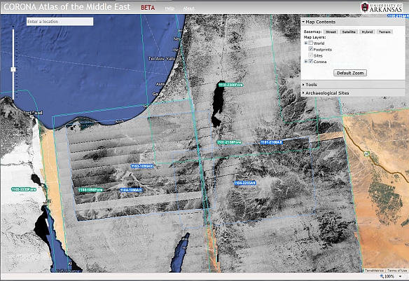
The team plans on adding more images from Corona, such as areas of Russia and China.