July 4th is almost here, and that means fireworks again! The fireworks app that has been used in the past few years has been updated, adding cities in San Bernardino County. Continue reading
Fireworks 2018!
2

July 4th is almost here, and that means fireworks again! The fireworks app that has been used in the past few years has been updated, adding cities in San Bernardino County. Continue reading
At the 2018 ESRI User Conference on July 9th, the Plenary session will be live streamed on the internet from 8:30am to 3:30pm PDT. So if you cannot make the conference, you can at least check out the Plenary session. Recorded videos will also be available online afterward.

UPDATE: View videos here.
The 2018 ESRI User Conference in San Diego is rapidly approaching. Is your government agency sending you to the conference this year? Why not attend the State and Local Government Social at the Hilton on Wednesday, July 11 from 6-8pm? Hope to see you there!
ESRI is hosting a webinar series dedicated to the trends, technical advancements, best practices, and special topics relating to GIS in public safety. Each webinar highlights a different subject relevant to your organization’s missions, workflows, and operations. Upcoming webinars include the following:
Visit the ESRI Public Safety Webinar Series website to register for upcoming events and stay up to date with GIS solutions for public safety agencies.

The Center for Spatial Studies at UCSB is hosting a poster and plenary session on campus on June 6th. The Plenary session will be on “Improving Information Accuracy for Extreme Events”. For more info and to RSVP, click below.

The California Geographic Information Association (CGIA) Board nominations are still open, but will close at the end of the day tomorrow. Nominate yourself or someone that would like to run for the following openings:
Board Officer positions open for nominations:
Board Member Categories open for nomination:
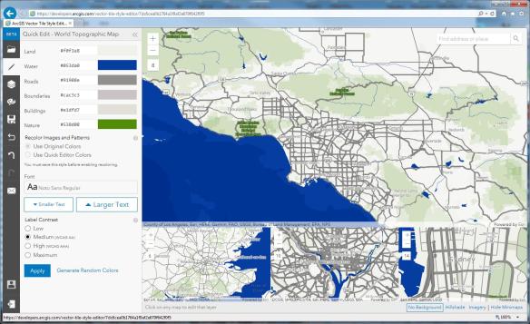
ESRI has announced the release of the ArcGIS Vector Tile Style Editor, available in beta on the ArcGIS for Developers website. The tool gives you a fast and easy way to create a custom basemap style.
By selecting an existing vector basemap, you can customize the layer colors and labels. You can edit everything from fill and text symbols to fonts, halos, patterns, transparency, and zoom level visibility. When you are finished, the styles are saved as an item in ArcGIS Online with a unique ID. The map viewer or any custom application can then reference the ID to display the basemap. Check it out.
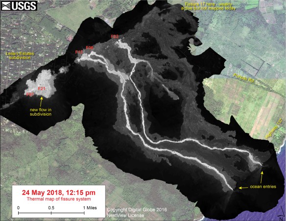
With all that is going on in Hawaii, the USGS is keeping up by mapping the fissure systems and lava flows of the eruption at Kilauea. They also have been taking thermal images so you can really see where the lava is flowing. Check it out!
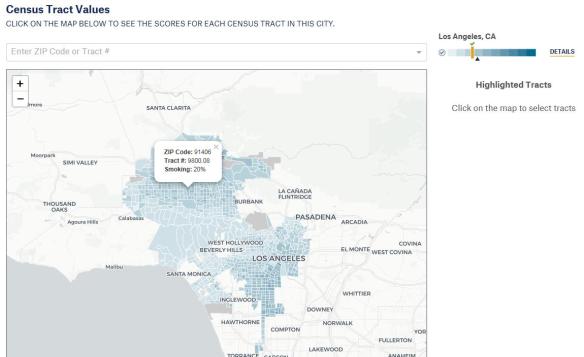
The City Health Dashboard is an online resource with community-level health, social, and economic data for the 500 largest cities in the US. The dashboard reports on 36 key measures of health, such as obesity and opioid overdose deaths, as well as the conditions that influence health, such as housing affordability and reading proficiency. The dashboard represents a first of its kind effort to provide city and neighborhood level data from multiple national sources, creating a one stop online resource to help city leaders and residents pinpoint and take action on gaps in health and opportunity. Check it out!
The ArcGIS Pro 2.2 Beta release will be available soon. The release will include new color schemes, 3D slice tool, full-motion video in the ArcGIS Image Analyst extension, UTM zone clipping, and about 50 new geoprocessing tools. Click below for more info and to sign up.