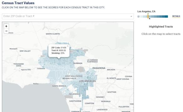
ESRI announced that there is a security vulnerability in ArcGIS server and there is a patch for 10.2.1 through 10.6. Version 10.6.1 has already been fixed. Click here to read the technical support article.
Category Archives: News
2017 Geography Graduate Program Rankings
Though the article is from last year, I think it still applies if you are a student looking for a great Geography Graduate Program for the fall. You can check out the rankings here.
Some top schools in California include UCLA, UC Santa Barbara, and UC Berkeley.
The article also touches on why online might not be a good idea for a graduate program and just taking GIS courses for a GIS certificate does not give you a deeper understanding of the world and teach you the ability to think spatially … Geography will.
Caring For Your Globe Collection
Census 2020 Hackathon
The Los Angeles Public Library is hosting the first ever hackathon focused on the 2020 Census to ensure that everyone gets counted in Los Angeles. If you want to participate, click here to RSVP. The event is on Sunday May 6, 2018 from 9am to 6pm.
Finding and Mapping National Parks
The US National Park Service boasts an extensive, well-designed website that features resources for educators, nature lovers, history enthusiasts, and anyone interested in learning more about the many U.S. national parks and sites. Check out the Find a Park page, which allows you to quickly locate parks and historic sites of interest. Using the interactive map, you can find parks by state and view a variety of statistics about park visitors and land area in each state. You can also conduct a text search to find a particular park. You can also scroll down on the main page to check out a list of fee-free days at national parks.
ArcGIS Earth 1.7 Beta
The ArcGIS Earth 1.7 Beta is now available. In this release users can look forward to the ability to identify and display metadata and attribute information for map services, image services, and WMS services on the globe, a smoother navigation experience, improved rendering for KML, improved drawing elements, labeling in multiple languages, and a new startup experience for first time users. Additionally, administrators will have the ability to customize startup criteria to meet the needs of their organization.
Click below to find out more and how to sign up for beta testing.
Future Communities Forum
SCAG’s Future Communities Forum, a unique gathering of researchers, business and civic leaders, and policymakers from Southern California and around the world, will showcase how technology and open data are being used to solve common challenges.
The forum will be held Wednesday, May 2 from 11:30 a.m. to 4:30 p.m. at the Renaissance Indian Wells Resort & Spa. Click below for more info and to register.
Cities at Night
Astronauts on board the International Space Station (ISS) take hundreds of night-time pictures each year of cities around the globe. Cities at Night is a “citizen science project that aims to create a map, similar to Google maps, of the Earth at night using night-time color photographs taken by astronauts onboard the ISS.” Check out the photographs that have been geo-referenced to the Earth, or join in and help the project team geo-reference new photographs!
Drones Flying Free 2018
Useless FCC Broadband Map
In February the FCC released their new broadband map showing the availability of high-speed internet in the US. Many of you might remember their previous map which turned out to be completely useless. Well … this new one seems to be about the same, not matching the reality on the ground. Click below to read more about the story.
A great example of how to lie with maps. Hey! There’s a book about that! You should get it, it’s a great book.


