PostGIS 2.2.4 was recently released. It is a patch release. For all the details and to download, click below.
![]()
Also version 2.3.1 was just released. Click here for more details.

PostGIS 2.2.4 was recently released. It is a patch release. For all the details and to download, click below.
![]()
Also version 2.3.1 was just released. Click here for more details.
The U.S. Environmental Protection Agency (U.S. EPA) has published a new report, Climate Change Indicators in the United States, 2016 (Fourth Edition), which includes seven new indicators and a feature on climate and health. EPA partners with more than 40 data contributors from various government agencies, academic institutions, and other organizations to compile a key set of indicators related to the causes and effects of climate change.

Today is GIS Day! If you are looking for a place to check out, may I suggest the GIS Day celebration at Los Angeles County. They put on a big show and have many booths and presentations.
You can find other places that are celebrating GIS Day by checking out the GIS Day map below.
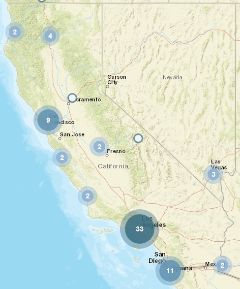
Happy GIS Day!
A new study from the USGS suggests that some early 20th century earthquakes in southern California might have been induced (man-made) by past practices that were used by the oil and gas industry.
In the new study, scientists evaluated the likely cause of several significant earthquakes within the Los Angeles Basin between 1900 and 1933, together with consideration of available oil industry records over this period.
They found that several damaging earthquakes, Continue reading
Check out these free, educational webinars from the U.S. Government Publishing Office (GPO), taking place this November.
Beyond Google – Another Look at Finding Government Information, November 9, 2:00 p.m. – 3:00 p.m. (Eastern): https://www.fdlp.gov/about-the-fdlp/fdlp-events-calendar/event/220-beyond-google-another-look-at-finding-government-information
OSHA’s Web Pages: A Wealth of Occupational Safety Information, November 10, 2:00 p.m. – 3:00 p.m. (Eastern): https://www.fdlp.gov/about-the-fdlp/fdlp-events-calendar/event/223-osha-s-web-pages-a-wealth-of-occupational-safety-information
Measuring America Series: Accessing International Data, November 16, 2:00 p.m. – 3:00 p.m. (Eastern): https://www.fdlp.gov/about-the-fdlp/fdlp-events-calendar/event/221-measuring-america-series-accessing-international-data
U.S. Naval War College Information Resources: Maritime, Naval History, Geopolitical, and Educational Treasures, November 17, 2:00 p.m. – 3:00 p.m. (Eastern): https://www.fdlp.gov/about-the-fdlp/fdlp-events-calendar/event/222-u-s-naval-war-college-information-resources-maritime-naval-history-geopolitical-and-educational-treasures
Science Soup: Mix Your Way through the Ingredients of Some Major Science Databases: Science.gov, PubMed, and WorldWideScience, November 29, 2:00 p.m. – 3:00 p.m. (Eastern): https://www.fdlp.gov/about-the-fdlp/fdlp-events-calendar/event/226-science-soup-mix-your-way-through-the-ingredients-of-some-major-science-databases-scitence-gov-pubmed-and-worldwidescience
Using the BEA Interactive Data Tool to get Local Data, November 30, 2:00 p.m. – 3:00 p.m. (Eastern): https://www.fdlp.gov/about-the-fdlp/fdlp-events-calendar/event/224-using-the-bea-interactive-data-tool-to-get-local-data
Presenters from GPO, other Federal Government agencies, and from Federal depository libraries across the Nation will present on topics related to Federal Government information and the Federal Depository Library Program. All sessions are presented virtually through GPO’s FDLP Academy: https://www.fdlp.gov/about-the-fdlp/fdlp-academy.
Attendees will receive a Certificate of Participation from GPO for each webinar they attend. Closed captioning is available for all webinars. Registrants will be sent access information upon registering. View their complete archive of recorded webinars and webcasts at http://login.icohere.com/public/topics.cfm?cseq=1172.
Governments already using the Esri ArcGIS platform can quickly and easily exchange data with Waze through the Waze Connected Citizens Program, a free, two-way data share of publicly available traffic information.
Waze provides governments with real-time, anonymous, Continue reading
My name is Jordan Sugar and I am a student with the UCLA Anderson School of Management in Los Angeles. As part of my Master’s Thesis, I am working with a team of MBA students to provide consulting services for a company that provides usage and performance analytics and capacity testing for spatial web services (like a Google Analytics for web-based maps). The company is interested in expanding operations to the United States, and our goal is to determine if an expansion would be successful and to provide a relevant recommendation.
We have put together a brief survey about GIS analytics, and I wanted to see if you would be willing to share it with your members. As an extra incentive, one lucky respondent will receive a $50 Amazon gift card! Here is a link to the survey: http://ucla.qualtrics.com/SE/?SID=SV_8oaJPWRYqoqwRDv.
Please let me know if you have any questions or suggestions. Thank you for your time and assistance!
Jordan Sugar
UCLA Anderson, Class of 2017
jordan.sugar.2017@anderson.ucla.edu
For those of you that keep your ArcGIS maintenance current, the ArcGIS 10.5 pre-release is available for you to download from your ESRI account. This includes ArcGIS Desktop, ArcGIS Enterprise, and ArcGIS Engine.
Note that existing ArcGIS 10.1-10.4.1 authorization numbers will continue to work with ArcGIS Desktop and ArcGIS Engine 10.5. At 10.5, ArcGIS Server is renamed to ArcGIS Enterprise. ArcGIS Enterprise requires ArcGIS 10.5 authorization numbers. When upgrading to 10.5, you will need to reauthorize for use.
ArcGIS Pro 1.4 is currently in alpha and continues to build towards functional equivalency with ArcMap while bringing its own innovations to desktop GIS and providing greater support for Web GIS. It features an improved and innovative user experience for processing and analyzing imagery; a new, secure, cross-platform scripting language for rendering and labeling; and greater capabilities for creating and using vector tiles. For those of you that have current ArcGIS maintenance, your account manager should have email from ESRI on how to participate in the alpha software testing program.
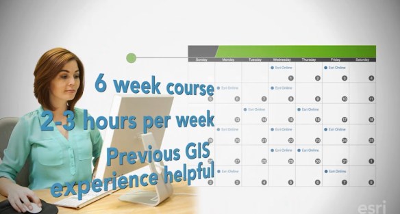
This course is for people who know something about spatial analysis and want to learn what ArcGIS Online has to offer. You’ll get free access to the full analytical capabilities of ArcGIS Online during the course. Course at a glance: