ArcGIS API for Python

ArcGIS API for Python provides GIS users with a Python API for their Web GIS (Online, Portal, or Enterprise in the cloud).  It provides simple and efficient tools for GIS users sophisticated vector and raster analysis, geocoding, map making, routing and directions, as well as for organizing and managing a GIS with users, groups and information items.

In addition to working with your own data, the library enables access to ready to use maps and curated geographic data from Esri and other authoritative sources. It also integrates well with the scientific Python ecosystem and includes rich support for Pandas and Jupyter notebookContinue reading

August 21, 2017 Solar Eclipse

For those of you that have read this blog for a while, you might remember me mentioning the Great American Solar Eclipse for 2017 in a post back in October 2015!  Well, it looks like the media woke up about it, because it is all over the news now.  It is finally here, just one week away on August 21st!  More info here.

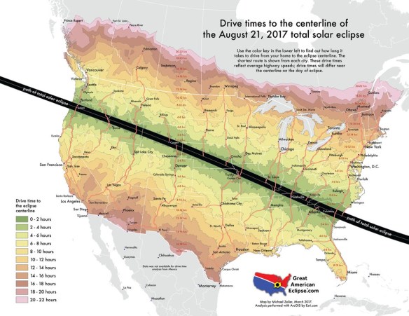
Are you going to travel up north or to the east to see it?  Below is a handy map showing how may hours it will take you to drive to the closest area to view the total solar eclipse:

eclipsedrivetimes

Continue reading

Guerrilla Cartography Kickstarter

Guerrilla Cartography has a kickstarter for their upcoming Water Atlas project.  Contribution options include adding your location to the collaborators map, receiving a copy of the book, or even donating a copy of the book to your favorite school, library, or community center with your name printed on the inside cover.  Check it out.

guerrillacartography

Thanks goes to Chandler Sterling for pointing this one out!

GIS Certificate at Rio Hondo College

GIS Fall Semester classes starts August 21st 
Pursue your GIS Certificate at Rio Hondo College.  Registration starts next week.  Apply for admission and register for classes entirely online.

Fall semester classes include two Introduction to GIS (GIS 120) courses including one located off site at the LA County Department of Public Works (DPW) at 900 S Fremont Ave, Alhambra.  Also offered is Cartography (GIS 221) and Intermediate GIS (GIS 220).

For more information visit http://riohondo.isteaching.com/fall-semester-2017.html or contact Prof Warren Roberts gisteacher@gmail.com .

World Imagery Firefly

World Imagery Firefly was created for thematic maps.  Currently in beta, Firefly is an alternative view of the default World Imagery basemap, and is designed with desaturated colors.  When zoomed out, the map appears grayscale, but as you zoom in, the colors become more saturated until the full color detail of the imagery appears.  World Imagery Firefly is especially useful for overlays of  brightly styled layers when you want an imagery basemap, but do not want the imagery to compete with the layer styling.  Check it out.

worldimageryfirefly

2017 ESRI User Conference Plenary

esri_uc_2017

Monday was the opening day to the 2017 ESRI User Conference in San Diego.  The Plenary session was full of info as usual.  It was all about Web GIS, Exploratory Data Analysis (Insights for ArcGIS), ArcGIS Pro, and ArcGIS Server.  Some highlights from my notes:

  • Vector tiles can be in your own projection
  • Publish your models as a service
  • Use Enterprise Builder to quickly set parameters and will install/configure Web Adaptor, Portal, Server, and Data Store all at once
  • ArcGIS Pro supports annotation, grids and graticules in layouts, auto georeferencing tool for images, the Catalog is back, supports WFS, onscreen navigator for 3D navigation, dark themed version to use Pro in low light conditions, also can have multiple Pro windows open at the same time
  • ArcGIS Online has a feature where you add online imagery as a layer to your map and then when you click on it you get resolution/collection data info in the popup, also a better geocoder and you can right click to get “what’s here” info
  • Scene Viewer supports vector tiles, projected coordinate systems, 3D smart mapping, new sets of photo realistic 3D symbols, callouts, labels, declutter options, ability to view massive point clouds quickly, photo realistic scenes

I’m sure the whole Plenary session from today will be viewable soon on ESRI’s video webite.