Check out how San Diego Harbor Police integrates GIS technology, video, and radar systems to keep people safe in the Port of San Diego.
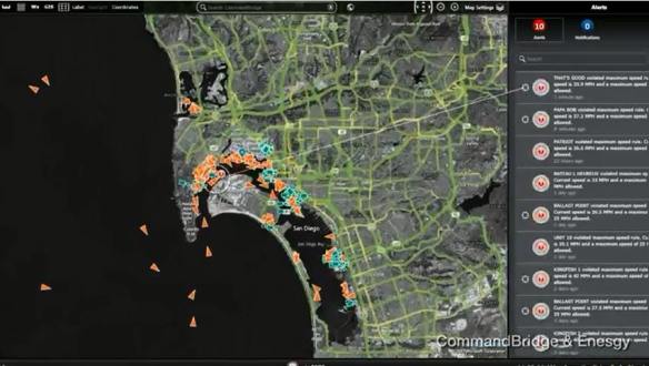

Check out how San Diego Harbor Police integrates GIS technology, video, and radar systems to keep people safe in the Port of San Diego.
I remember sitting at my desk at work that morning in 2001 watching what was going on in New York. The City’s cable access channel staff had their TV feeds going all day long.
I also remember how quiet it was in the sky when I got home that evening. That day the FAA closed all airspace and grounded all flights.
It went from this (9:30am EDT):

to this (after 12pm EDT):
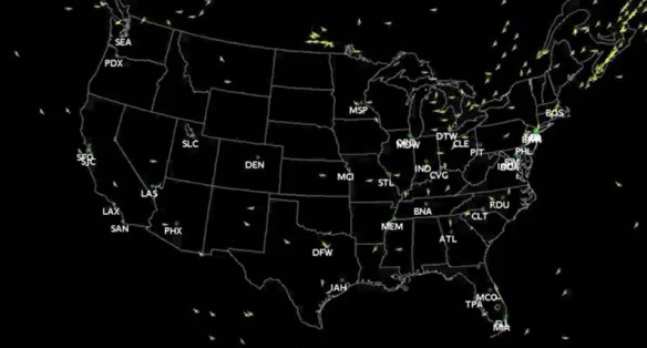
It was very quiet over the skies in SoCal on the 12th. Flights resumed on the 13th and 14th in tiers. By the 21st they were fully restored. Watch the video here. For more info on 9/11, click here.
ESRI has released three new ArcGIS Pro styles for Emergency Management, Local Government, and State Government industries for version 2.0. For example, the Local Government style contains symbols for election polling places, real estate transactions, community events, parks, damage assessment, right of way assets, non-emergency problem reports, catch basins, and fire hydrants.
Visit the ArcGIS Blog post for more info.
At the ESRI User Conference in July, attendees were able to get their questions answered by the ArcGIS Pro team at the ArcGIS Pro Panel Discussion. In case you missed it, check out every question and answer from the panel by clicking below.

I find the answer to “when can I publish directly to Server from ArcGIS Pro” very interesting.
Directions Magazine has a good overview of the 2017 FOSS4G Conference that was held in Boston. You can read it here.
The Geospatial Information and Technology Association (GITA) will be hosting a webinar by John Wertman of the Association of American Geographers on the Geospatial Data Act of 2017. The webinar will take place online on Tuesday, August 29, 2017 from 11:00 am – noon, PDT. To attend the webinar, go to http://www.gita.org/events/event_details.asp?legacy=1&id=997052.
From the press release:
John Wertman from the American Association of Geographers (AAG) will lead a webinar on the Geospatial Data Act (GDA), legislation that could effectively exclude everyone but licensed architects, engineers, and surveyors from federal government contracts for GIS and mapping services of all kinds – not just those services traditionally provided by surveyors. The GDA is primarily focused on reauthorizing and implement several key federal geospatial data programs. The bill, however, also includes provisions creating a system of exclusionary procurement that would prevent most companies and organizations in the dynamic and rapidly growing GIS and mapping sector from receiving federal contracts for a very-wide range of activities, including GPS field data collection, GIS, internet mapping, geospatial analysis, location based services, remote sensing, academic research involving maps, and digital or manual map making or cartography of almost any type. Join this informative webinar to learn more about the GDA and how organizations have been responding to the legislation.
Bio: John Wertman serves as Senior Program Manager for Government Relations at the Association of American Geographers (AAG). He is a past Chair of the Coalition of Geospatial Organizations (COGO) and is now the AAG’s delegate to COGO. His career has focused on positions in and around politics, and he previously served as Special Assistant to the Director of Presidential Letters and Messages at the White House during the Administration of President Bill Clinton. Wertman also held government relations positions at the Consortium of Social Science Associations, the University of Virginia Medical Center, and the American Urological Association. He interned on Capitol Hill for both former Congressman Tom Davis and former House Minority Leader Dick Gephardt. Wertman holds a BA in Government from the University of Virginia.
Missed the 2017 ArcGIS User Seminar? Did you know there was one? I actually forgot about it myself. However, ESRI kindly sent me an email to remind me I missed it and had a link to the videos. The seminar covers ArcGIS Pro, Insights for ArcGIS, ArcGIS apps, and much more, to help you get the most out of ArcGIS. Check it out.

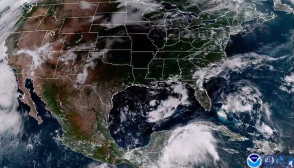
The solar eclipse across the US was today. Did you see it? The GOES-16 satellite caught the moon’s shadow travel across the US. Check it out!
I had a telescope setup projecting the sun on a table. 63% obscuration was about it for SoCal, but still pretty cool:

ArcGIS API for Python provides GIS users with a Python API for their Web GIS (Online, Portal, or Enterprise in the cloud). It provides simple and efficient tools for GIS users sophisticated vector and raster analysis, geocoding, map making, routing and directions, as well as for organizing and managing a GIS with users, groups and information items.
In addition to working with your own data, the library enables access to ready to use maps and curated geographic data from Esri and other authoritative sources. It also integrates well with the scientific Python ecosystem and includes rich support for Pandas and Jupyter notebook. Continue reading
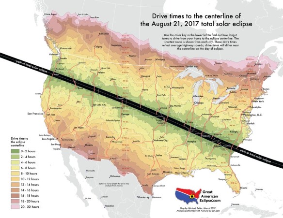
For those of you that have read this blog for a while, you might remember me mentioning the Great American Solar Eclipse for 2017 in a post back in October 2015! Well, it looks like the media woke up about it, because it is all over the news now. It is finally here, just one week away on August 21st! More info here.
Are you going to travel up north or to the east to see it? Below is a handy map showing how may hours it will take you to drive to the closest area to view the total solar eclipse: