2018 NAIP Imagery

Looking for 2018 NAIP imagery of California?  The 2018 NAIP county mosaics are available for download now.  The imagery is available in both natural color and near infrared.

What is NAIP?  NAIP stands for the National Agriculture Imagery Program.  NAIP acquires digital ortho imagery during the agricultural growing seasons in the continental US.  NAIP provides 60 centimeter ground sample distance (GSD) ortho imagery rectified to a horizontal accuracy within +/- 4 meters of reference digital ortho quarter quads (DOQQ’s) from the National Digital Ortho Program (NDOP) or from the National Agriculture Imagery Program (NAIP).  The tiling format of NAIP imagery is based on a 3.75′ x 3.75′ quarter quadrangle with a 300 pixel buffer on all four sides.  The NAIP imagery is formatted to the UTM coordinate system using the North American Datum of 1983 (NAD83).  NAIP imagery may contain as much as 10% cloud cover per tile.  This file was generated by compressing NAIP imagery that cover the county extent.  Two types of compression may be used for NAIP imagery: MrSID and JPEG 2000. The target value for the compression ratio is 40:1 for imagery.

NAIP imagery is typically available for distribution within 60 days of the end of a flying season and is intended to provide current information of agricultural conditions in support of USDA farm programs.  For USDA Farm Service Agency, the 1 meter and 1/2 meter GSD product provides an ortho image base for Common Land Unit boundaries and other data sets.  NAIP imagery is generally acquired in projects covering full states in cooperation with state government and other federal agencies who use the imagery for a variety of purposes including land use planning and natural resource assessment.  NAIP is also used for disaster response often providing the most current pre-event imagery.

ca_naip2018_nc

Tax Freedom Day 2019

Ah taxes!  In case you have not been paying attention, they are due today!

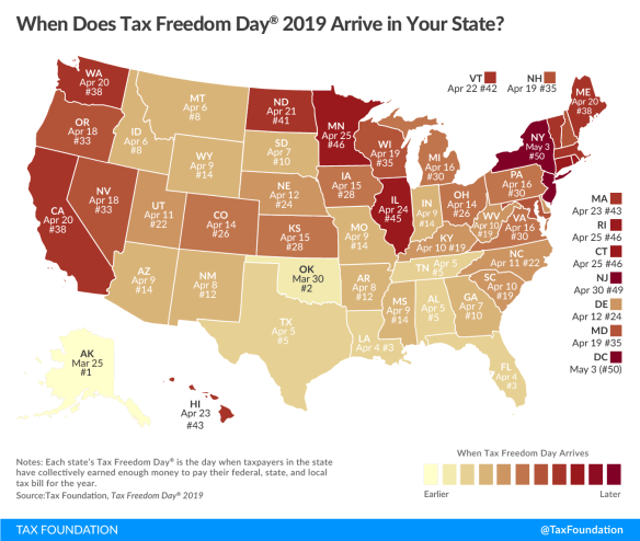
This year Tax Freedom Day is April 16th, 105 days into the year.  What is Tax Freedom Day?  It represents how long Americans as a whole have to work in order to pay the nation’s tax burden.  Think of it as the number of days each year you work for the feds, state, and city to pay them off!  For California, Tax Freedom Day comes April 20!  Click below for more info on this interesting topic!

tfd-2019-map-01

ArcGIS 10.7 Now Available

ESRI has announced that ArcGIS 10.7 is now available for download.  For those of you with current maintenance, you can download it from my.esri.com.  See the What’s New for Desktop and Enterprise.

Some notes about installing ArcGIS 10.7:

The ArcGIS 10.7 setup packages are designed to detect and upgrade an existing installation of the same ArcGIS product. The settings for the installation location and authorization information are retained during the upgrade. See the installation guide for more information on installation upgrades and new installations.

ArcGIS 10.7 Single Use Licenses:

If ArcGIS 10.7 will be installed on a machine that is different from where a previous ArcGIS 10.x product is currently installed and you wish to use the existing ArcGIS 10.1—10.6.1 authorization number for ArcGIS 10.7, the earlier version of an ArcGIS 10.x product must first be deauthorized before authorizing ArcGIS 10.7.

ArcGIS 10.7 Concurrent Use Licenses:

  • The copy protection mechanism for ArcGIS Desktop 10.7 and ArcGIS Engine 10.7 Concurrent Use requires that ArcGIS License Manager 2018.1 be installed to support these products.
  • Existing ArcGIS 10.1—10.6.1 authorization numbers will work with ArcGIS Desktop and Engine 10.7.
  • Existing ArcGIS Enterprise 10.6—10.6.1 authorization numbers will not work with ArcGIS Enterprise 10.7. You must obtain a 10.7 authorization number.


ESRI Acquires indoo.rs GmbH

ESRI has announced the acquisition of indoo.rs GmbH, a provider of Indoor Positioning System (IPS) technology.  The indoo.rs software will become part of ESRI’s ArcGIS Indoors, a mapping product that enables interactive indoor mapping of corporate facilities, retail and commercial locations, airports, hospitals, event venues, universities, and more.  The acquisition will also provide users of ESRI’s ArcGIS platform with imbedded IPS location services to support indoor mapping and analysis.  The indoo.rs headquarters will also serve as an ESRI R&D centre based in Vienna, Austria, focused on cutting-edge IPS capability.

Mappy Hour at CalPoly Pomona

The Southern California Chapter of URISA is sponsoring a Mappy Hour at the CalPoly Pomona Campus (Innovation Brew Works) on March 19th at 5:30 pm – 7:30 pm.  Attendees are invited to share their Geo-related projects, GIS initiatives and their plans for global or local GIS domination.

Students are encouraged to attend to learn about GIS opportunities regionally and within URISA including internships, competitions and conference scholarships.  Light snacks will be provided and beverages are available for purchase.

Parking is available without a permit after 5 P.M. in Lot “O” near Innovation Village on Campus.  Click here for more info.

Geo Innovation and Entrepreneurship

The Center for Information Systems and Technology, at Claremont Graduate University, is expanding its outreach to the GIS community. As part of this effort, they are co-hosting with ESRI, a one-day conference entitled “Geo Innovation and Entrepreneurship”.

The event is scheduled for April 11th and will be held on their campus in Claremont. There are two sessions and you are welcome to attend one or both. You are also invited to attend their evening reception at the end of the day should you not be able to attend the other sessions.

A detailed outline regarding the conference, sessions, and presenter biographies is located on Eventbrite.

There is no cost to attend, other than your time, and they will be providing refreshments during the sessions as well as lunch.  Check it out!

“Daylight Saving” Time?

Once again “Daylight Saving” is upon us.  I put that in quotes because nothing is being saved … more like stolen!

timezones

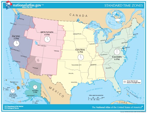
You heard the expression “robbing Peter to pay Paul”?  That is what Daylight Saving Time does, it pushes your state into the time zone to the east, so California moves into the Mountain Time Zone.  But nature does not care, the sun will rise and set as usual, however because you shifted your clock to the east it GIVES THE ILLUSION of setting later in the day … and rising later as well!  If you are a morning person, dealing with that extra darkness in the morning really sucks!

Continue reading