Geo Innovation and Entrepreneurship

The Center for Information Systems and Technology, at Claremont Graduate University, is expanding its outreach to the GIS community. As part of this effort, they are co-hosting with ESRI, a one-day conference entitled “Geo Innovation and Entrepreneurship”.

The event is scheduled for April 11th and will be held on their campus in Claremont. There are two sessions and you are welcome to attend one or both. You are also invited to attend their evening reception at the end of the day should you not be able to attend the other sessions.

A detailed outline regarding the conference, sessions, and presenter biographies is located on Eventbrite.

There is no cost to attend, other than your time, and they will be providing refreshments during the sessions as well as lunch.  Check it out!
“Daylight Saving” Time?

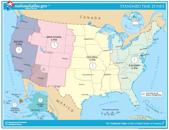
Once again “Daylight Saving” is upon us.  I put that in quotes because nothing is being saved … more like stolen!

timezones

You heard the expression “robbing Peter to pay Paul”?  That is what Daylight Saving Time does, it pushes your state into the time zone to the east, so California moves into the Mountain Time Zone.  But nature does not care, the sun will rise and set as usual, however because you shifted your clock to the east it GIVES THE ILLUSION of setting later in the day … and rising later as well!  If you are a morning person, dealing with that extra darkness in the morning really sucks!

Continue reading →

SCAG 2019 Student Showcase

The Southern California Association of Governments, or SCAG, is excited to announce a major opportunity for college and university students in the region. On May 2, 2019 SCAG’s annual Regional Conference & General Assembly will feature a special Student Showcase session featuring sustainability planning posters and GIS Story Maps selected through a competitive application process. This will be an opportunity for students to share their work with more than 1,000 elected officials, planners, and regional leaders.

Students whose projects are chosen will be designated as SCAG Conference Fellows, receiving complimentary event registration, hotel accommodation and admission, and access to local elected officials and planning experts on Southern California. Additionally, projects from each category will be will be selected to compete for thousands of dollars in cash prizes, four cash prizes totaling $6,000.

For more information about the contest, click here.

Students may also sign up for free Story Map training on March 15th at SCAG.  To register for the training session, please RSVP here.

For questions, please contact Mike Jones at (213) 236-1978 or jonesm@scag.ca.gov.

Earn Your MSGISci at CSULB

If you are interested in earning a graduate degree in GIS, consider the Masters of Science in Geographic Information Science (MSGISci) degree at California State University Long Beach (CSULB). The MSGISci is a 1-year, 30-unit MS degree program. In-person classes are offered on weeknights and weekends to accommodate working professionals. Program details and application instructions can be found at http://www.beachgis.com. Review of completed applications begins April 1, 2019.

Goodbye NAD 83 and NAVD 88

Back in 2015 I wrote about the planned retirement of NAD 83 and NAVD 88.  Well, it’s almost here.  The new replacement datums are coming in 2022.

To improve the National Spatial Reference System (NSRS), NGS will replace the North American Datum of 1983 (NAD 83) and the North American Vertical Datum of 1988 (NAVD 88) with a new geometric reference frame and geopotential datum in 2022.

The new reference frames Continue reading →

College of the Canyons GIS

Need to fulfill a beginning GIS requirement?  Or just want to expand your knowledge and learn a new skill?  Then come join me at College of the Canyons and sign up for GIS 101, Introduction to Geographic Information Systems.  I promise you the class will be challenging and rewarding!  Also, your earned units are UC/CSU transferrable.

GIS 101 is filling up quickly, so register for the Spring semester as soon as possible.  The GIS class will meet at the Valencia campus every Tuesday from 6:30pm to 9:35pm, February 5 to May 28.  We start next week!

Feel free to contact me, Michael Carson (michael.carson@canyons.edu), if you have any questions.

Unintended Consequences with Data

Many of us that create GIS data and share with others have no idea of the unintended consequences that the data might produce.  Using data and ignoring the scale, resolution, accuracy, and where it came from might produce very wrong results.

Click below to read this rather long story about how location data married with IP addresses is causing a horror show for a couple in South Africa, and this is not the only case.

xcq4aeibiq7wrjxbfg7o