Check out this story of the man behind the Cahill-Keyes world map projection. You can buy a high resolution 61″ x 29″ wall map of it by clicking below.

Crisp 4pt font and 0.05mm thick semi-transparent lines!

Check out this story of the man behind the Cahill-Keyes world map projection. You can buy a high resolution 61″ x 29″ wall map of it by clicking below.
Crisp 4pt font and 0.05mm thick semi-transparent lines!
ESRI’s ArcGIS Online team made a change to the World Topographic Map on February 3, 2014. This will affect you if you reference the sub layers. Check out their blog post for more info.
If you use Geocortex Essentials, this may affect you as well. If you use the topo base map, you might see warnings from the Essentials REST manager. To fix it, do the following:


Thanks goes to Doug Yates at NorthSouth GIS for the fix.
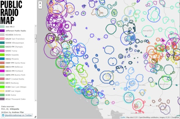
An interactive open source map showing public radio stations in the United States and Canada. Nice to know when on a long car trip. Don’t zoom out to far, I found the map slows down to a crawl and starts to trip up displaying the data. Other than that, very informative.
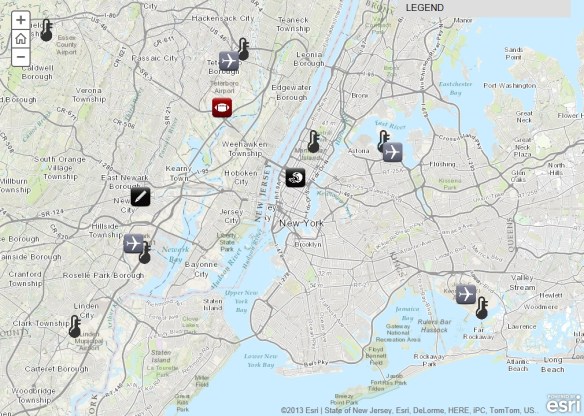
Super Bowl XLVIII will take place on Sunday, February 2, at MetLife Stadium in New Jersey. See where the game will be played and explore a series of maps that will tell you everything you need to know about the NFL’s annual championship game. Explore everything from live temperature feeds and transportation infrastructure in the New York/New Jersey region to the 10 coldest Super Bowls of all time.
Gotta love those robotic birds. The FAA predicted in 2012 that within 20 years time there could be as many as 30,000 drones flying over the US soil alone. Are you prepared to identify them? Get your survival guide today!

A new smartphone app called EnLighten is telling drivers how long they might be waiting at traffic lights. Inventor Matt Ginsberg’s novel creation predicts when a red light will turn green.

Demographic data down to the block level on DVD … and it’s free!
Availability: Summary File 1 is available as a two DVD set. The DVDs contain the 2010 Census Data Engine retrieval software allowing users to manipulate, display, and download data from the file.
Discs:
For more information and to order the free DVD set, visit this US Census page.
Here’s another one I found for your SoCalGIS info fix … and yes I am catching up from vacation! 🙂 -mike
In 1973, the United States Army produced training film TF5-4523 entitled, “The Mapmaking Process” which it described as explaining the “theory of mapmaking, and illustrates the methods and techniques used to produce maps; planning, surveying, compiling, and reproduction.” Retrieved from the National Archives, the training video is available in three parts for viewing.
Read more and watch the video posted on GIS Lounge:

Hello Pacific Region GIS data users.
In our continuing series of educational GIS webinars for CA, HI, and NV, we would like to follow up the recent EarthExplorer call with one on an equally important USGS data distribution site – The National Map Viewer.
Please join us for a webinar and call on Thursday, January 30 at 11:00 HST, 1:00 PM PST. To sign up for the webinar, just visit the following link to register:
https://usgs.webex.com/usgs/j.php?ED=259146402&RG=1&UID=0&RT=MiM0
Once you have registered for the meeting, you will receive an email message confirming your registration. This message will provide the information (including conference call numbers) that you need to join the meeting. Note that our webinar capacity and phone lines are both limited to 50 people. So depending on the number of people interested, we may not be able to accommodate everyone. But we will monitor the registrations and keep you informed..
This site has lots of GIS-ready data available for free download. We will go over data access, USGS products, viewing data, and web services. Your instructors will be Carol Ostergren and Drew Decker.
From our website (nationalmap.gov/viewer):
Use The National Map Viewer and Download Platform to visualize, inspect, and download our most current topographic base map data and products for free. Managed by the USGS National Geospatial Program (NGP), The National Map Viewer provides access to all eight primary data themes of The National Map to include US Topo and historical topographic map products.
Data include: Elevation, Orthoimagery, Hydrography, Geographic Names, Boundaries, Transportation, Structures, and Land Cover, while products include: US Topo and Historical Topo Maps. The National Map Viewer also allows visualization and identification queries (but not downloads) of Other Featured Data, to include Scanned Topo Maps, Ecosystems, Protected Areas, Gap Analysis Program Land Cover, Wetlands, Public Land Survey System, and National Park Service Boundaries. Also included is a Natural Hazards panel to view hazards-related information, such as for earthquakes, floods, wildfires, and weather, along with the U.S. National Grid for emergency response.
Hope you are able to join us! Contact either of us with any questions.
Thanks,
Carol Ostergren
Drew Decker
——————————————–
Drew Decker
USGS Geospatial Liaison for Pacific Region
NSDI Partnership Office, U.S. Geological Survey
4165 Spruance Road, Suite 200
San Diego, CA 92101
619-225-6430
619-417-2879 cell
619-225-6101 fax
ddecker@usgs.gov
http://liaisons.usgs.gov/geospatial/California/
http://liaisons.usgs.gov/geospatial/Hawaii/
USNG 11S MS 8026 2158
Just in case you have not seen it all yet in 2013, The Lake Mosters of America map!


