If you missed the Sharpen Your GIS Skills Seminar put on by ESRI last fall, you can view it online here:
http://www.esri.com/events/seminars/fall-seminar-series
Included is data used in the demos so you can try it out too.
If you missed the Sharpen Your GIS Skills Seminar put on by ESRI last fall, you can view it online here:
http://www.esri.com/events/seminars/fall-seminar-series
Included is data used in the demos so you can try it out too.
The Atlas of True Names reveals the etymological roots, or original meanings, of the familiar terms on today’s maps of the World, Europe, the British Isles, Canada and the United States.
For instance, where you would normally expect to see the Sahara indicated, the Atlas gives you “The Tawny One”, derived from Arab. es-sahra “the fawn coloured, desert”.
Here is a True Names map of the USA. Click for more info.

I saw this poster created using a DEM from Lidar data. Very beautiful presentation of a river with a shallow elevation range.

Looks like the EPA will be releasing their ArcGIS data to the public using ESRI’s cloud option. Read more here.
And here is more on ESRI’s ArcGIS Open Data.
Take a look at this video from the ESRI Federal GIS conference. Something new that will be released in March, The Executive Briefing Book. It is optimized for use on a tablet and organizes your content like pages in a book.

Check out this story of the man behind the Cahill-Keyes world map projection. You can buy a high resolution 61″ x 29″ wall map of it by clicking below.

Crisp 4pt font and 0.05mm thick semi-transparent lines!
ESRI’s ArcGIS Online team made a change to the World Topographic Map on February 3, 2014. This will affect you if you reference the sub layers. Check out their blog post for more info.
If you use Geocortex Essentials, this may affect you as well. If you use the topo base map, you might see warnings from the Essentials REST manager. To fix it, do the following:


Thanks goes to Doug Yates at NorthSouth GIS for the fix.
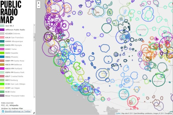
An interactive open source map showing public radio stations in the United States and Canada. Nice to know when on a long car trip. Don’t zoom out to far, I found the map slows down to a crawl and starts to trip up displaying the data. Other than that, very informative.
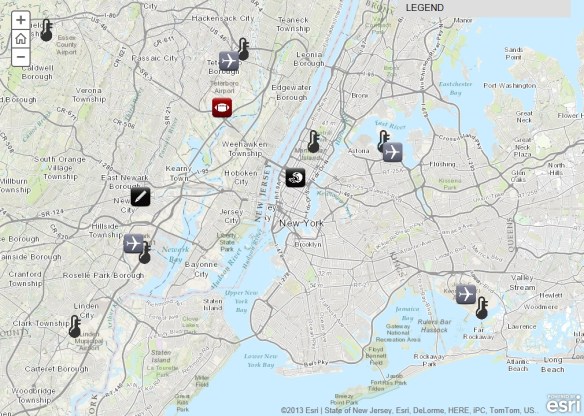
Super Bowl XLVIII will take place on Sunday, February 2, at MetLife Stadium in New Jersey. See where the game will be played and explore a series of maps that will tell you everything you need to know about the NFL’s annual championship game. Explore everything from live temperature feeds and transportation infrastructure in the New York/New Jersey region to the 10 coldest Super Bowls of all time.
Gotta love those robotic birds. The FAA predicted in 2012 that within 20 years time there could be as many as 30,000 drones flying over the US soil alone. Are you prepared to identify them? Get your survival guide today!

