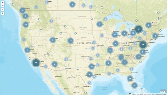
Wishing everyone a very Merry Christmas and a Happy New Year. Enjoy this year’s Christmas Card Map! -mike

If you are looking for last minute gifts for that mapper type, check out National Geographic’s site!
Wishing everyone a very Merry Christmas and a Happy New Year. Enjoy this year’s Christmas Card Map! -mike
If you are looking for last minute gifts for that mapper type, check out National Geographic’s site!
Two years ago I mentioned James Niehues and his ski resort maps that he had made over the years. Now there is a Kickstarter campaign to create a hardcover coffee table book and art print series of his work. Check it out!

Have a few minutes to spare before your next task? Open Google Maps and turn on the satellite imagery. Now zoom all the way out until you see Earth and listed on the left are planets, moons, and other objects you can zoom to and check out. See you in an hour!

Sir Francis Galton was the first to identify the anticyclone (as opposed to the cyclone), and introduced the use of charts showing areas of similar air pressure – the modern weather map. His book Meteorographica was the first systematic attempt to gather, chart and interpret weather data on a continental scale, a fundamental work of modern scientific meteorology.
Galton prepared the first weather map published in the British newspaper The Times (April 1 1875, showing the weather from the previous day, March 31), now a standard feature in newspapers worldwide. Click below to read more about Sir Francis Galton.

Standing out on the shoreline, have you ever wondered if you set sail straight ahead across the sea what other beach would you run into? Check out the Beyond The Sea interactive map. You can move your mouse along a shoreline or click on a country to visualize all the locations which lie directly across the sea. Location names will be displayed once the track hits land. Colors of the lines represent the different destination continents. Try the Start Fireworks button too for an impressive display!

Looking for that interesting map book or atlas for the cartographic nut in your family? Or maybe for you! Check out this listing of map books that were published or are scheduled to be published in 2018, with a few in 2019.

GIS Day 2018 is finally here. I am sure most of us GIS types are going to show off our work this week. Here are a few locations celebrating GIS Day this week:
Los Angeles County
City of Irvine
City of Riverside
UC Riverside
Ventura College
CSU Northridge
UCLA
Palomar College
Also check out the GIS Day map for a location near you!
Check out this satellite image of the fires in California and the smoke that has blown out to sea. It was taken at noon today.

You can view full disk images of the Earth and different sensor images and loops at the GOES East Image Viewer.
Americans are expected to spend about $9 billion on Halloween this year as they buy costumes, decorations, greeting cards and candy for the annual Oct. 31 event.
The National Retail Federation estimates that more than 175 million Americans are planning to participate in Halloween activities this year, spending about $3.2 billion on costumes, $2.7 billion on decorations, and $2.6 billion on candy.
Bulk candy dealer CandyStore.com looked through 11 years of data to come up with the favorite Halloween candy in each U.S. state. Continue reading
When you mail a letter or package with the United States Postal Service (USPS), unless you pay for tracking, you may no know when it will arrive at its destination. If you mail your rent check on October 27, will it reach your landlord before the end of the month?
The USPS has a handy mapping tool for that. Continue reading

