In a recent poll, more than 10,000 burger fans nationwide were asked to name their favorite burger from a major fast food establishment or restaurant chain. Though the map does not show you the distribution of fast food chains, or lack of certain ones, it does show you people’s preferences in their region. Check out the Burger Map!
Category Archives: Fun Stuff
Wind Speed Interactive Map
GOES East Image Viewer
How America Uses Its Land
You may enjoy this interesting series of interactive data visualizations showing land use in the continental United States based on different categorizations used by the US Department of Agriculture. I found it interesting when you organize all the categories together that pasture and rangeland would take up most of the Western US and all of the country’s cities and towns would fit in the Northeast. Check it out!
California Place Names
Ever wonder where that place name came from? I found a scanned copy of a 1916 journal article “California Place Names of Indian Origin” on the UC Berkeley Library website. Check out this entry for Azusa:


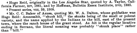
Ha! I like footnote #6, and I paraphrase: some guy living in Azusa quotes some other guy who’s godfather said it means “skunk hill” because of the skunks, the small polecat variety, on the hill named “Azuncsabit” by the Indians, east of the town where the ranch house of the grant stood.
And here I thought Azusa got it’s name from the phrase “the best city from A to Z in the USA!”
You can download the PDF of the journal article here.
I also bought this book many years ago and it’s pretty interesting if you are into the etymology of place names:
Know Where Sharks Are
Cold War LA
Between 1956 and 1974 those living in Los Angeles had little idea that they were surrounded by numerous nuclear warheads. 16 Nike missile sites as well as radar and control sites were established to defend the Los Angeles area, just in case Russia decided to send their bombers our way. Read about it and more on the Cold War LA website!
Phantom Islands – A Sonic Atlas
The term “phantom island” refers to an island that appeared on historical maps (sometimes for many years) even though it doesn’t exist. Most phantom islands emerged from the era of European sea exploration and colonization. Phantom Islands – A Sonic Atlas is a project that pairs original sound recordings with 27 phantom islands. Each of these islands are placed according to their coordinates on historical maps. Visitors can explore these individual islands by either taking a “cruise” or by navigating with their cursor. As one visits each island, they will hear a unique soundscape and can read about the island’s history, including the date of the island’s first and last appearance in print. Check it out!
Fireworks 2018!
July 4th is almost here, and that means fireworks again! The fireworks app that has been used in the past few years has been updated, adding cities in San Bernardino County. Continue reading
The Phantom Atlas
Looking for a gift for someone who loves maps? Take a look at The Phantom Atlas. Long before satellites and Google, cartographers traced out maps of the world, some with errors that persisted for hundreds of years. The Phantom Atlas compiles the greatest “myths, lies and blunders” on maps, from honest mistakes to deliberate lies. Check out this interview with the author:
Hardcover and Kindle versions available on Amazon:


