Check out this interesting article about books with maps that you might have read when you were young. The maps were used to describe the fictional world you were reading about.


Check out this interesting article about books with maps that you might have read when you were young. The maps were used to describe the fictional world you were reading about.
Throughout the 17th and 18th centuries, many believed California was a remote island with plenty of gold, free-loving amazons, and strange beasts.
A new exhibit at Cal State Fullerton’s Pollak Library features a selection of maps from the Roy V. Boswell Collection for the History of Cartography, one of the University’s special collections. The exhibit, “California As an Island and Worlds That Never Were,” will be on display Jan. 22 to March 29 in the Salz-Pollak Atrium Gallery.
Looking to go on a road trip? If you know your stops, why not let Python figure out the most optimum route for you? Click below to learn how it is done.

The National Oceanic and Atmospheric Administration (NOAA) has released the first image taken by Harris Corporation’s Advanced Baseline Imager (ABI) onboard their next-generation weather satellite. The image taken from the Geostationary Operational Environmental Satellite-16 (GOES-16) is of Earth’s full western hemisphere with detailed cloud and water features.
Uber is providing access to anonymized data from over 2 billion trips to help improve urban planning around the world. Uber movement provides a new way on how traffic is moving around in your city. It was designed in partnership with urban planners and transportation professionals. Tools are included to analyze traffic changes over time. Check it out!

Thanks goes to Barry Waite for finding this one!
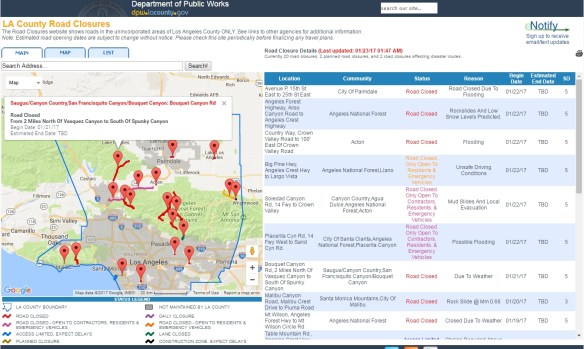
With all the rain we have been receiving, I thought this site might be useful for those driving around. LA County Department of Public Works has a road closures website which shows road closures in the unincorporated areas of the county ONLY. So if you plan on travelling in the mountains, you would probably want to consult this site.
Check out this article about mapping building shadows of New York City. Building shadows were measured using a shadow accumulation technique and the dates of December 21 (winter solstice), June 21 (summer solstice), and September 22 (autumnal equinox) were chosen for the shadow profile. Shadows can be greatly distorted when they are near the horizon, so all the shadows in the model were estimated from one and a half hours after sunrise and one and a half hours before sunset.

Thanks goes to Mary Bates from College of the Canyons for finding this article!
Jack Dangermond from ESRI talks about five GIS trends that are changing the world. Check it out.

Check out these maps that show the massive scope of America’s infrastructure using data from OpenStreetMap and various government sources.

52 19th and early 20th century maps of California have been added to the California Historical Society’s new Digital Library. The images represent a sampling of unique or uncommonly held titles ranging geographically from an 1863 map of the copper region of Del Norte County in the north, to a circa 1866 Topographical Map Showing the Locations of the Sutro Tunnel and the Comstock Lode, to a colorful 1913 townsite map of Date City (now called Calipatria) in Imperial County in the south. In between are city, county, mining, real property, water-supply, road, and railroad maps of various localities throughout the state. Check it out!