Wishing you all a very Merry Christmas and a Happy New Year. Enjoy this year’s Christmas Card Map! -mike

If you are looking for last minute “map” type gifts. Check out this site!


Wishing you all a very Merry Christmas and a Happy New Year. Enjoy this year’s Christmas Card Map! -mike
If you are looking for last minute “map” type gifts. Check out this site!
Whether you are an ArcGIS Online subscriber or an ArcGIS Hub user, you can launch an open data site in 3 steps, which include configuring and designing the site and making it public. Check out ESRI’s post about it here.
The California GIS Council Meeting is today. Attend in person if you are local, or attend via the web. One topic of discussion will be how GIS data was shared and used for analysis by CALFIRE, CANG, CALOES, and Napa County.
Other topics include the California Geodetic Control Work Plan, Geospatial Data Act of 2017, and the NAIP Program.
The agenda and how to connect via the web can be found on the CGIA website.
We recently upgraded to ArcGIS Desktop 10.5. Everything looked fine until we noticed all our locators we use for geocoding had disappeared from our enterprise geodatabase! Someone deleted the locators? Luckily we still had an older version of Desktop and checked the enterprise geodatabase, and they were all there. What? Then we tried to add a new locator to the geodatabase using 10.5 and the option was gone!
As it turns out, ESRI has decided at 10.5 that you can no longer create or use locators in geodatabases, including enterprise geodatabases. This means that prior to 10.5 address locators are visible inside of the geodatabase, but after installing 10.5 locators are no longer visible when viewing the contents of the geodatabase. In ArcGIS Pro 1.4 as well, address locators can no longer be seen inside of geodatabases to be able to use them as inputs into tools.
So now what? You must copy or move your address locators from geodatabases into file folders before installing 10.5, using copy/paste in ArcCatalog or running the Data Management Copy tool. You read that correctly! Locators must be in a file folder now, like you do with your shapefiles. Make sure to do this before you upgrade to 10.5! And if you want to give your users access to the locators, I guess you would have to place them on a network drive. Maybe you do that with other files already, so it won’t be a big deal for you.
Also if you use locators for a geocoding service in ArcGIS Server, they will fail in Server 10.5. They must be moved to file folders and used from there.
More info about this here.
The Los Angeles County Assessor has just released their 2016 tax roll parcels. The 2016 parcels (in a file geodatabase) with associated tax roll information can be downloaded at the Los Angeles County GIS Data Portal.

Rio Hondo College GIS courses start the week of January 29th 2018. http://riohondo.isteaching.com/spring-semester-2018.html Apply for admission and register for classes entirely online. Available courses include Introduction to GIS (GIS 120), Cartography Design and GIS (GIS 221) located off site at the LA County Department of Public Works (900 S Fremont Ave, Alhambra), also offered is GIS Applications (GIS 220) on Fridays and a second offering TTh evening, and the Environmental GIS (GIS 230) course on MW evening.
Waivers are available if you are unable to meet prerequisites due to scheduling, if you have experience using GIS or attended an introductory course elsewhere. Contact wroberts@riohondo.edu for support. For more information on the courses you can view here and you can follow steps here to register.
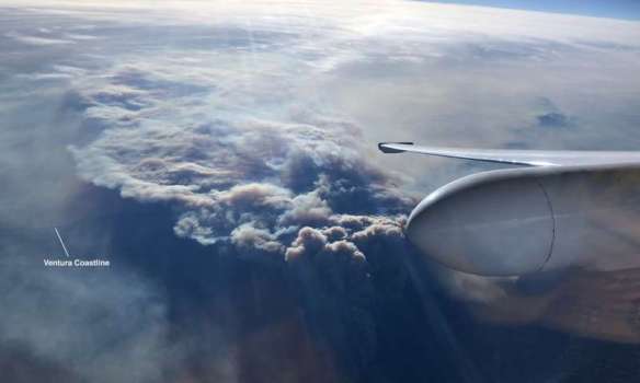
NASA is using a high-altitude aircraft and a sophisticated imaging spectrometer to study environmental impacts caused by the devastating Southern California wildfires. Click below to read the article.
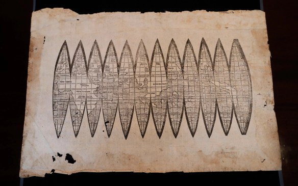
A newly discovered print of Martin Waldseemüller’s 1507 map was to be sold at auction this month until experts raised concerns about its authenticity. The Waldseemüller map is considered to be the first to mention America. Click below for the story and how it was discovered to be a fake.
The 2018 ESRI User Conference Registration is now open. Hurry and register for the conference to get your favorite hotel before they fill up!

Check out this image of the Thomas, Creek, and Rye Fires today at 10:25am.

Source: NASA Earthdata, MODIS Near Real Time Images

