Many companies are becoming more open about how and where their products are manufactured. The Nike Manufacturing Map is an interactive map which shows the location of independent factories contracted to make Nike products. The map also allows you to access information about the product made by each factory and data about the employees. Continue reading
Author Archives: socalgovgis - Michael Carson
Atlas of Historical County Boundaries
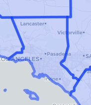
Wondering how the boundary of Los Angeles County looked like in 1851? Here you go:

Here it is in 1887, just before Orange County was created the year after:

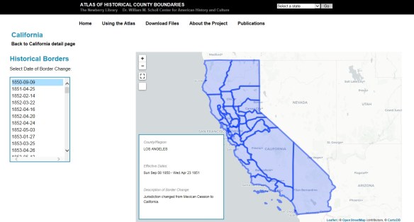
The Atlas of Historical County Boundaries allows you to explore how county boundaries have shifted throughout history. You can also download GIS shapefiles of polygons for each different configuration of a state’s counties or the entire United States, coded by date. Check it out!
CGS Seismic Hazards Program Update
The California Geologic Survey (CGS) Seismic Hazards Program has significantly updated two versions of its regulatory hazard zone map products. First, all GIS data files (in ESRI Shapefile format) for fault rupture, liquefaction and earthquake-induced landslide zones have been re-projected to California (Teale) Albers, in meters, with a North American Datum 1983. In addition, all GIS zone polygons now include attributes that provide the name of the 7.5-minute quadrangle, map release date(s), and links to zone reports and PDF maps. Active fault traces within earthquake fault zones have attributes for fault name and fault type. Continue reading
Concurrent Use Licensing is Back!
Did you miss it? Probably not.
Some of you might have known about this last year. I never reported on it since the story kept changing throughout 2017. However, if you missed the controversy, ESRI was going to phase out the ability to use Concurrent Use licensing starting with ArcGIS Desktop 10.5. Continue reading
Interdisciplinary Earth Data Alliance
The Interdisciplinary Earth Data Alliance (IEDA) data facility aims to, “support, sustain, and advance the geosciences by providing data services for observational geoscience data from the ocean, earth, and polar sciences.” The IEDA, which is funded by the US National Science Foundation, is headed by staff at Columbia University’s Lamont-Doherty Earth Observatory. On this website, you will find a number of data repositories and data syntheses, which are collections of data sets with a shared area of investigation. Data repositories include information in the fields of Antarctic science, marine geology and geophysics, and geochronology. You can also download the free GeoMapApp, which is a free software tool for creating data visualization. Check it out!
Merry Christmas 2017
Wishing you all a very Merry Christmas and a Happy New Year. Enjoy this year’s Christmas Card Map! -mike
If you are looking for last minute “map” type gifts. Check out this site!
Create an Open Data Site
Whether you are an ArcGIS Online subscriber or an ArcGIS Hub user, you can launch an open data site in 3 steps, which include configuring and designing the site and making it public. Check out ESRI’s post about it here.
CA GIS Council Meeting Today
The California GIS Council Meeting is today. Attend in person if you are local, or attend via the web. One topic of discussion will be how GIS data was shared and used for analysis by CALFIRE, CANG, CALOES, and Napa County.
Other topics include the California Geodetic Control Work Plan, Geospatial Data Act of 2017, and the NAIP Program.
The agenda and how to connect via the web can be found on the CGIA website.
No More Locators in Geodatabases
We recently upgraded to ArcGIS Desktop 10.5. Everything looked fine until we noticed all our locators we use for geocoding had disappeared from our enterprise geodatabase! Someone deleted the locators? Luckily we still had an older version of Desktop and checked the enterprise geodatabase, and they were all there. What? Then we tried to add a new locator to the geodatabase using 10.5 and the option was gone!
As it turns out, ESRI has decided at 10.5 that you can no longer create or use locators in geodatabases, including enterprise geodatabases. This means that prior to 10.5 address locators are visible inside of the geodatabase, but after installing 10.5 locators are no longer visible when viewing the contents of the geodatabase. In ArcGIS Pro 1.4 as well, address locators can no longer be seen inside of geodatabases to be able to use them as inputs into tools.
So now what? You must copy or move your address locators from geodatabases into file folders before installing 10.5, using copy/paste in ArcCatalog or running the Data Management Copy tool. You read that correctly! Locators must be in a file folder now, like you do with your shapefiles. Make sure to do this before you upgrade to 10.5! And if you want to give your users access to the locators, I guess you would have to place them on a network drive. Maybe you do that with other files already, so it won’t be a big deal for you.
Also if you use locators for a geocoding service in ArcGIS Server, they will fail in Server 10.5. They must be moved to file folders and used from there.
More info about this here.
LA County 2016 Parcels
The Los Angeles County Assessor has just released their 2016 tax roll parcels. The 2016 parcels (in a file geodatabase) with associated tax roll information can be downloaded at the Los Angeles County GIS Data Portal.