The 2019 ESRI User Conference Proceedings are now available for you to view and download papers from user presentations and slides from technical workshops. Check it out here!
2019 ESRI UC Proceedings
Reply

The 2019 ESRI User Conference Proceedings are now available for you to view and download papers from user presentations and slides from technical workshops. Check it out here!
Take advantage of this free NG9-1-1 workshop. Topics include:
The workshop is for:
The workshop will be held September 24, 2019 from 10am to 2:30pm at 333 Olympic Drive, Santa Monica. Lunch will be provided. Park in the Civic Parking Structure on the corner of 4th & Olympic.
To RSVP, visit http://bit.ly/SantaMonicaScissors .
What is HIPAA compliant geocoding? Read this executive brief on safe and secure geocoding for protected health information.
You fly a drone? Then you must be familiar with LAANC, the Low Altitude Authorization and Notification Capability. It provides drone pilots with access to controlled airspace at or below 400 feet. Included is an FAA web app that provides near real-time authorization to conduct drone flights in controlled airspace. Drone pilots can use it to easily locate LAANC enabled airports, understand the airspace classification, determine the latitude/longitude of the proposed flight location, and view altitude restriction grids. Apps such as FAADroneZone, AirMap, Aeronyde, Converge, Kittyhawk, Skyward, and UASidekick will provide the map and the ability to acquire LAANC authorizations.
The web map is also available to the public. Check it out!

Looking for a GIS class this Fall 2019? Here are some local colleges that are offering GIS classes:
Cal Poly Pomona – GIS (GEO 2400/2400L), GIS Programming (GEO 3220/3220L)
CSU Dominguez Hills – GIS (GEO 415)
CSU Fullerton – Intro to GIS (GEOG 481), GIS Principles and Apps (GEOG 485), Map Making with GIS (GEOG 281)
CSU Long Beach – Intro to Digital Cartography (GEOG 380), Enterprise GIS (GEOG 484)
CSU Los Angeles – Intro to Geospatial Sciences (GEOG 2680), Fundamentals of GIS (GEOG 3690), Spatial Analysis and GIS Modeling (GEOG 4690)
CSU Northridge – Intro to GIS (GEOG 206/206L), Intermediate GIS (GEOG 306/306L), Advanced GIS (GEOG 406/406L), GIS Project Management (GEOG 408C/408CL)
CSU San Bernardino – Intro to GIS and Cartography (GEOG 202)
Claremont Graduate University – GIS Essential Concepts (IST 370)
Cypress College – Intro to GIS (GEOG 230C/F), GIS Spatial Analysis (GEOG 231C)
East Los Angeles College – Intro to GIS (GIS 025)
Loyola Marymount University – Intro to GIS (EVST 1010 or URBN 1010)
Mt. San Jacinto College – Intro to GIS (GEOG 115)
Occidental College – GIS I (GEO 150/150L)
Palomar College – GIS and Spatial Reasoning (GEOG 150)
Pasadena City College – Intro to GIS (GEOG 011), Map Interpretation and Spatial Analysis (GEOG 012), Data Acquisition and Management (GEOG 013)
Pierce College – Intro to GIS (GIS 025), Intermediate GIS Applications (GIS 033)
Pomona College – GIS in Environmental Analysis (EA 101 PO/EA 101 LPO)
Rio Hondo College – Intro to GIS (GIS 120), Intermediate GIS (GIS 220), Environmental GIS (GIS 230), Crime Mapping GIS (GIS 281), Cartography Design and GIS (GIS 221), Geospatial Programming & Web Services (GIS 280)
San Bernardino Valley College – Intro to GIS (GEOG 130)
San Diego Mesa College – GIS and Spatial Reasoning (GISG 104), Intro to Mapping and GIS (GISG 110), Spatial Analysis with GIS (GISG 112)
San Diego State University – GIS and Spatial Reasoning (GEOG 104), GIS Scripting Fundamentals (GEOG 383), Spatial Data Analysis (GEOG 385), GIS (GEOG 484)
Santa Monica College – Intro to GIS (GIS 20), Intermediate GIS (GIS 23), Applications in GIS (GIS 27)
UCLA – Intro to GIS (GEOG 7), Intro to Spatial Statistics (GEOG M171), GIS Programming and Development (GEOG 173), Geographic Data Visualization and Analysis (GEOG 208)
UCLA GIS Extension – Intro to GIS (GEOG XL 7), Intermediate GIS (GEOG XL 168), Advanced GIS (GEOG XL 170)
UCR GIS Extension – Essential GIS Skills (ERT X454.65), Principles of Web GIS Applications (ERT X453.61), GIS Applications Lab (ERT X453.4)
UCSB – Intermediate Geographical Data Analysis (GEOG 172), Intro to GIS and Science (GEOG 176A)
University of Redlands – Fundamentals of GIS (GIS 611)
USC – GIS for Policy, Planning, and Development (PPD 631)
USC Spatial Sciences – Maps and Spatial Reasoning (SSCI 301L), Statistics for the Spatial Sciences (SSCI 381), Spatial Computing (SSCI 580), Spatial Databases (SSCI 582), Spatial Analysis (SSCI 583), Geospatial Technology Project Management (SSCI 585), GIS Programming and Customization (SSCI 586), Web GIS (SSCI 591)
Ventura College – Fundamentals of Mapping and GIS (GIS V22), Intro to Mapping and GIS (GIS M01)
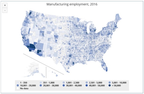
Found this interesting website about a new report examining about how the geography of US employment in manufacturing and other industries has changed over approximately the past 75 years. This report found that “the manufacturing industry has lost ground in many places across the US and is now the largest employer in only two states–Indiana and Wisconsin.”
Check out the interactive visualizations and maps. The first two visualizations allow you to explore shifts in employment and economic output trends from 1940 to 2016 for a variety of industries at both the national and state level. The other three visualizations focus on changes in the manufacturing industry in more recent decades and include data down to the county level. You can also download the full 56-page report. Check it out!
 ESRI has released their new book GIS and the 2020 Census. The book provides statistical organizations with the most recent methodologies and technological tools to support all stages of the census. The book covers planning, enumeration and field data collection, and post-enumeration tasks: converting existing data, field operations, data processing and dissemination, developing geographic products, and much more. Case studies from Albania, Portugal, Republic of the Philippines, Jordan, Arab Republic of Egypt, Ireland, and Canada demonstrate the successful application of the tools. Ancillary materials are available online and include the updated census data model Global Statistical Geospatial Framework, the United Nations (UN) Handbook on the Management of Population and Housing Censuses, and much more.
GIS and the 2020 Census has 264 pages and is available in soft-cover and as an e-book. Sample text can be found here.
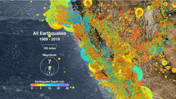
A new video from the Pacific Tsunami Warning Center maps every earthquake recorded in California in the last 30 years. Check it out below.
The video starts in August 1989 and ends July 5, 2019 with the magnitude 7.1 quake in Ridgecrest. The largest earthquake in the last 30 years was the magnitude 7.3 quake in the small Mojave Desert town of Landers in June 1992.
There is a composite image at the end of the video of all earthquakes, and really there are only a few areas in California that are earthquake free!
To give you the opportunity to demonstrate your skills using this next generation story builder, ESRI invites you to enter the 2019 StoryMapper of the Year Contest. The contest will also give you the chance to give back to your community at the same time!
The StoryMapper of the Year Contest started July 8, 2019, and the deadline for submission is 5:00 p.m. (PDT), September 30, 2019. The contest submissions must be created using ArcGIS StoryMaps, not classic ESRI Story Maps apps.
The 2019 contest will work differently than contests in years past. To up the ante, ESRI added a monetary prize and community element. When participants submit their entries, they will also describe how they would use a $5,000 donation from ESRI to make a positive impact on their communities through storytelling.
The winners will be announced by ESRI president Jack Dangermond on November 13, 2019, which is GIS Day. Good Luck!
Geography 2050 is a multi-year, strategic dialog about the vital trends reshaping the geography of our planet in the coming decades. Initially organized by the American Geographical Society (AGS) in 2014, the ongoing Geography 2050 dialogue convenes thought leaders from academia, government, industry, and the social sector to facilitate discussion of the major forces that will shape our planet’s future. In the late 20th century, talk of a borderless world began to take hold among many in both academia and the media as the end of the Cold War and the forces of globalization rapidly impacted the planet. While many aspects of globalization led to greater fluidity across international borders in terms of trade, capital, technology transfer, and the movement of people, this same period witnessed the creation of more international borders, not fewer. This symposium questions what the world map will look like in 2050 and how our practice of defining, maintaining, and even understanding the meaning of borders might change. Within each theme, we will look both at scenarios of increasing interdependence and division and how they could play out by 2050.
This year’s Symposium will focus on how geography and geospatial science impact the role of borders in our future economy, environment, and geopolitical situation. Click below for more info.

