Ok, this is a new one for me! Never heard of “technical debt”. I think it is more of a marketing ploy, but you be the judge. Click below to read the article.


Ok, this is a new one for me! Never heard of “technical debt”. I think it is more of a marketing ploy, but you be the judge. Click below to read the article.
Earlier this year, ESRI launched a new product called ArcGIS Platform, a platform-as-a-service (PaaS) offering that makes it easier to integrate ESRI location services into apps, solutions, and business systems. As a GIS professional, you already realize the benefits of GIS. However, it can be a challenge when developers in your organization need location services but are not familiar with the ArcGIS system or require the additional functionality provided by it. With ArcGIS Platform, developers and IT professionals can take advantage of location services—including basemaps, routing, geocoding, data, and geoenrichment—within their development environment through an industry-standard development experience, instead of needing a stand-alone set of services. This month, the ESRI state and local government team will present the following:
The webinar is March 17 at 10am. For more info and to register, click here.
The California Geographic Information Association (CGIA) will host a webinar today with the California State GIO about California GIS initiatives and a conversation about supporting new GIS professionals. The webinar will be today at 12:30pm. Click here for more info and to RSVP.
The National Maps Corps is an online crowdsourcing mapping project with volunteers successfully editing structures in all 50 States, Puerto Rico, and the U.S. Virgin Islands. Structures include schools, hospitals, post offices, police stations, cemeteries, and other important public buildings. By updating and verifying structures data, volunteers are making significant contributions to USGS National Structures Database, The National Map, and ultimately US Topo Maps.
If you have some time, why not do a little data editing? Click below and check it out.

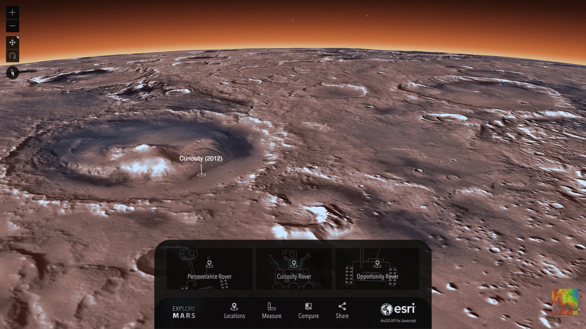
Check out this ESRI blog post about adapting planetary coordinate systems to then view in a 3D globe application like for Mars.
The OGC membership recently approved the new Indoor Mapping Data Format (IMDF). Read about it here.
One-Year MS in GIS @ CSULB – Apply Now for Fall 2021!
Geospatial is everywhere. Harness and hone your geospatial skills and the power of the technology through a Master of Science in Geographic Information Science (MSGISci) at California State University Long Beach (CSULB).
The MSGISci is a 1-year, 30-unit MS degree program offered through the Department of Geography at CSULB. Classes are scheduled on weeknights and weekends to accommodate working professionals. Program details and application instructions can be found at http://www.beachgis.com.
Application review will begin April 1st. The deadline for domestic applicants is June 1st and April 1st for international students.
Make sure to apply for financial aid for all graduate programs you may be considering. https://fafsa.ed.gov/.
The Quick Access Toolbar, located above the ribbon in ArcGIS Pro, is where you can add commands you often need. This toolbar quickly puts those commands at your fingertips. Check out his article which shows you how to customize it.

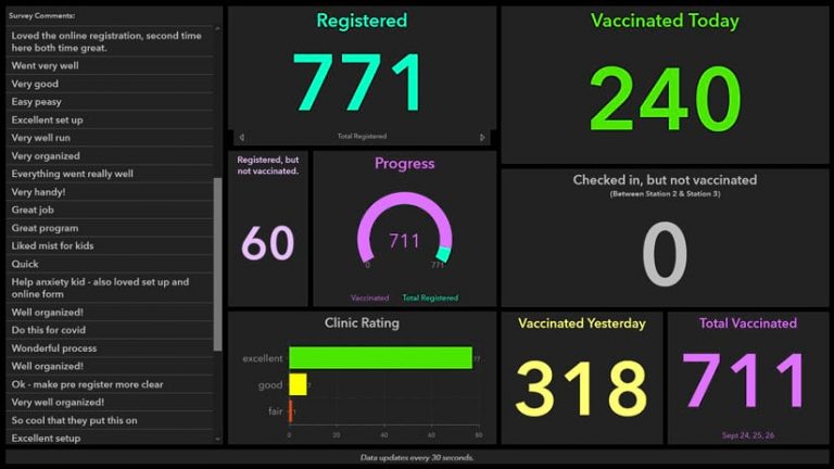
This one is interesting. The GIS Department for Carlton County, Minnesota, used ArcGIS Survey123, ArcGIS Hub, and ArcGIS Dashboards to help administer a drive-through flu vaccine clinic. Online forms created with ArcGIS technology made registration for the clinic safer, faster, and easier for the public. Dashboards provided real-time statistics, enabling county officials to quickly analyze how many people were being vaccinated. Click below to read the article.
Join the ArcGIS Earth team on February 24 for a technical session at the ESRI Federal GIS Conference to introduce the newest capabilities available in ArcGIS Earth. Whether you’re a first-time user or a seasoned professional, this session is designed to bring value to all ArcGIS Earth users by delivering a product overview as well as a demonstration of some of the newest, most exciting capabilities currently available, and a sneak peek into what’s on the roadmap. The session will be followed by a live Q&A with the product team to field all your questions related to ArcGIS Earth. Click here for more info and to register.
