
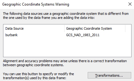
Burbank just got their LARIAC6 imagery. The projection that was used is a little different. It did catch me by surprise when I was comparing it to LARIAC5 imagery.
LARIAC5 – NAD_1983_StatePlane_California_V_FIPS_0405_Feet
LARIAC6 – NAD_1983_2011_StatePlane_California_V_FIPS_0405_Ft_US
Just enough to make ArcGIS Desktop complain!
NAD 83 (2011) is a new NAD 83 “realization”. It does not use a new datum. It is a refinement of the NAD 83 datum using data from a network of very accurate GPS receivers at Continuously Operating Reference Stations (CORS). From the point of view of GIS use, the difference is very slight and it will not be an issue when overlaying your older NAD 83 data.

How does it match with your parcels? I understand the county assessor made an adjustment to those.
Like before still pretty close in some areas and a little off in others.