Here is a good map showing right now the election results by state, county, size of lead, and change from 2012.
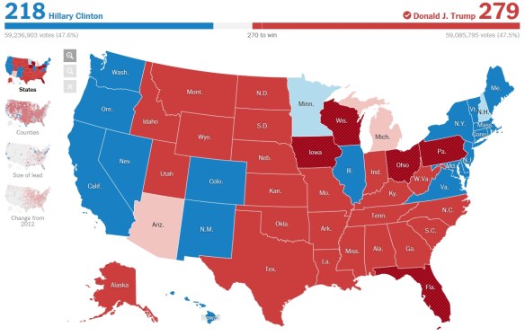
Also, if you live in LA County, check out the state/county/local election results here. For Orange County, click here.

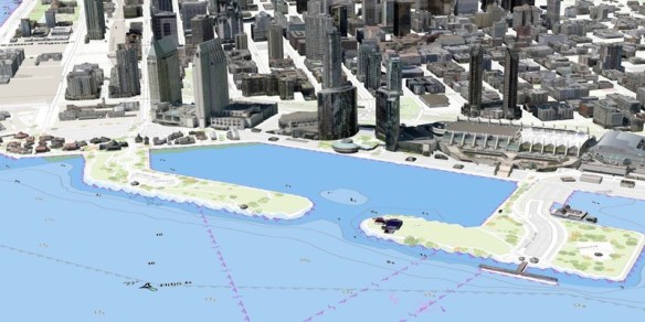
The Southern California Marine GIS User Group has announced it’s 2016 Fall Meeting hosted by the Port of San Diego. The Southern California Marine GIS is a welcoming group of GIS professionals and aficionados doing work in and about the Southern California marine and maritime community. Their goal is to create connections and foster innovation to improve and accelerate marine and maritime GIS in the local area. Click below for more info.
This ArcGIS Online web map shows imagery for the planet that is updated on a daily basis. It features the NASA MODIS imagery True Color band composition (Bands 1 4 3 | Red, Green, Blue) which most accurately shows how we see the earth’s surface with our own eyes.
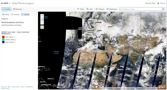
The image service supporting this map is time enabled, but time has been disabled on this image layer so that the most recent imagery displays by default. If you would like to view imagery over time, you can update the layer properties to enable time animation and configure time settings. The results can be saved in a new web map to use later or share with others. More about the MODIS imagery image service here.
A new study from the USGS suggests that some early 20th century earthquakes in southern California might have been induced (man-made) by past practices that were used by the oil and gas industry.
In the new study, scientists evaluated the likely cause of several significant earthquakes within the Los Angeles Basin between 1900 and 1933, together with consideration of available oil industry records over this period.
They found that several damaging earthquakes, Continue reading
Check out these free, educational webinars from the U.S. Government Publishing Office (GPO), taking place this November.
Beyond Google – Another Look at Finding Government Information, November 9, 2:00 p.m. – 3:00 p.m. (Eastern): https://www.fdlp.gov/about-the-fdlp/fdlp-events-calendar/event/220-beyond-google-another-look-at-finding-government-information
OSHA’s Web Pages: A Wealth of Occupational Safety Information, November 10, 2:00 p.m. – 3:00 p.m. (Eastern): https://www.fdlp.gov/about-the-fdlp/fdlp-events-calendar/event/223-osha-s-web-pages-a-wealth-of-occupational-safety-information
Measuring America Series: Accessing International Data, November 16, 2:00 p.m. – 3:00 p.m. (Eastern): https://www.fdlp.gov/about-the-fdlp/fdlp-events-calendar/event/221-measuring-america-series-accessing-international-data
U.S. Naval War College Information Resources: Maritime, Naval History, Geopolitical, and Educational Treasures, November 17, 2:00 p.m. – 3:00 p.m. (Eastern): https://www.fdlp.gov/about-the-fdlp/fdlp-events-calendar/event/222-u-s-naval-war-college-information-resources-maritime-naval-history-geopolitical-and-educational-treasures
Science Soup: Mix Your Way through the Ingredients of Some Major Science Databases: Science.gov, PubMed, and WorldWideScience, November 29, 2:00 p.m. – 3:00 p.m. (Eastern): https://www.fdlp.gov/about-the-fdlp/fdlp-events-calendar/event/226-science-soup-mix-your-way-through-the-ingredients-of-some-major-science-databases-scitence-gov-pubmed-and-worldwidescience
Using the BEA Interactive Data Tool to get Local Data, November 30, 2:00 p.m. – 3:00 p.m. (Eastern): https://www.fdlp.gov/about-the-fdlp/fdlp-events-calendar/event/224-using-the-bea-interactive-data-tool-to-get-local-data
Presenters from GPO, other Federal Government agencies, and from Federal depository libraries across the Nation will present on topics related to Federal Government information and the Federal Depository Library Program. All sessions are presented virtually through GPO’s FDLP Academy: https://www.fdlp.gov/about-the-fdlp/fdlp-academy.
Attendees will receive a Certificate of Participation from GPO for each webinar they attend. Closed captioning is available for all webinars. Registrants will be sent access information upon registering. View their complete archive of recorded webinars and webcasts at http://login.icohere.com/public/topics.cfm?cseq=1172.
There once was a tiny island at the entrance to the San Pedro harbor named Dead Man’s Island, which was named for the shallow graves dug into its flat top. The small island measured at least 800 feet long and 250 wide and rose 55 feet above the sea, separated from the San Pedro bluffs with almost a mile of open water between.
As part of a program of extensive harbor improvements, Continue reading
This interactive map displays non-seasonally adjusted California Labor Force and Unemployment Data for all 58 counties and 21 major cities ranked by population size.

The capability to easily create digital contours using commercial off-the-shelf (COTS) software has existed for decades. Out-of-the-box raw contours are suitable for many scientific applications without pre- or post-processing; however, cartographic applications typically require additional improvements. For example, raw contours generally require smoothing before placement on a map. Continue reading
Governments already using the Esri ArcGIS platform can quickly and easily exchange data with Waze through the Waze Connected Citizens Program, a free, two-way data share of publicly available traffic information.
Waze provides governments with real-time, anonymous, Continue reading
What many people love most about the fall are the vibrant colors that mark the transition from summer to winter. Temperature, the amount of sunlight, and precipitation all affect how quickly the foliage will change from green to red, yellow, or orange. This interactive tool illustrates where autumn colors are peaking across the United States.
The map uses data from NOAA precipitation forecasts, daylight and temperature forecasts, historical precipitation data for this year, as well as other government and private data sources to visually indicate the foliage change between August and November, noting seven degrees of change. In addition to helping users plan a weekend getaway to enjoy fall’s many colors, the site offers some science trivia about what causes leaves to be certain colors and why leaves fall. Check it out!

