Check out the live feed from the ESRI Developer Summit right now!
If you missed it, watch it here.

The Masters of Science in Geographic information Science (MSGISci) at California State University, Long Beach (CSULB) is currently accepting applications for Fall 2018. The MSGISci is a 1-year, 30-unit MS degree program; classes are offered on weeknights and weekends to accommodate working professionals.
Please visit www.beachgis.com for more details. Review of applications begins April 1st (please note the upcoming March 2nd FAFSA application deadline for CA applicants https://fafsa.ed.gov/deadlines.htm#).
QGIS 3.0 is the first release in the 3.x series. It comes with many new features and updates, however, it is only for early adopters or people who don’t mind bugs! For more info, visit their blog and click below to download.

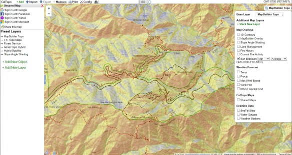
CalTopo is a handy tool for hikers and those that like the great outdoors. Besides having the USGS topos displayed as a background, it has been enhanced over last year so you can also overlay layers like slope shading, current fire activity and fire history, average sun exposure for a certain date and time, weather (temperature, precipitation, wind speed, and forecasts), and real time data (snow, water gauges, and weather stations), and other stuff! Print out your map too and head for the hills! Check it out.
Besides having a cool name, the Observatory of Economic Complexity is a tool that allows users to quickly compose a visual narrative about countries and the products they exchange. It was created by a student working on their Master Thesis in Media Arts and Sciences at the MIT Media Lab.
You can visualize a country’s import/export data by a tree map, stacked, network, rings, scatter, line, or geo map. Check it out!

Do you use Geocortex software? Want to know the latest and greatest in Geocortex technology? Join Drew Millen (Director, Products) and Lisa Cottrell (Marketing and Event Specialist) as they share their latest development work, and hear more about their plans for the future.
Intended for Geocortex licensees, topics include new and soon to be released features, upcoming events and training opportunities, deep dives into important Geocortex capabilities, and medium- and long-term plans on further integration with the ArcGIS platform and modern web GIS pattern.
The webinar will be on February 22 from 10-10:30am PST. You can register here.
The SoCal URISA Chapter is hosting two free Next Gen 9-1-1 events in Orange County on February 20th and LA County on February 21st.
Topics Covered:
For more info on these free workshops and to register, visit their Events page.
Thinking about deploying ArcGIS Online for your organization? Check out this interesting article outlining some key areas that need to be addressed for a successful implementation.

Learn to design beautiful maps with Dr. Kenneth Field, Senior Cartographic Product Engineer at ESRI. This 6 week cousre begins April 18th. You will learn how to use world-class GIS technology to gain the experience that employers seek. The course includes hands-on exercises, video discussions, quizzes, and demos, as well as a certificate of completion. Sign up!
THE 2018 RASKIN SCHOLARSHIP FOR STUDENTS OR EARLY-CAREER SCIENTISTS IN EARTH SCIENCE INFORMATICS
The Raskin Scholarship is awarded annually to an individual in the Earth or computer sciences who has an interest in community evolution of Earth science data systems. The Raskin Scholarship seeks to promote collaboration, research support, and exposure for talented students in the Earth or computer sciences. Special attention will be given to applicants demonstrating an interest in semantics, GIS, cyber infrastructure and computing in the geosciences. The Scholarship will provide a $5000 award and travel support to the ESIP summer meeting where they will have an invited talk covering their field of interest.
Details in brief:
For more details on eligibility and how to apply, please visit the ESIP website.

