Over the years, making a globe is still mostly a manual process.
Making a globe in 1935:
Globe making in 1955:
Making a globe today:

Over the years, making a globe is still mostly a manual process.
Making a globe in 1935:
Globe making in 1955:
Making a globe today:
Maptime LA will have their first meetup this Thursday in downtown LA. To RSVP, visit http://www.meetup.com/MaptimeLA/events/204145932/ .
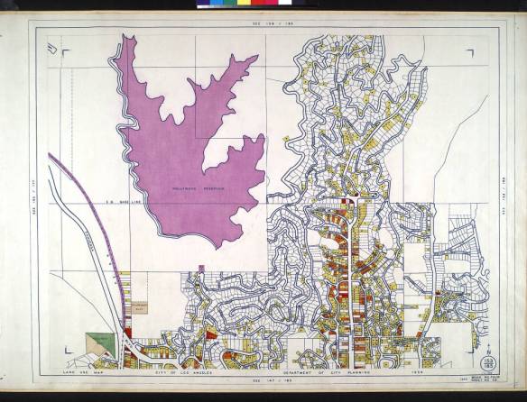
Developed as part of President Franklin D. Roosevelt’s massive package of assistance programs designed to pull the United States out of the Great Depression, the Works Progress Administration (WPA) was known for employing thousands of artists to paint murals in federal buildings and for also employing thousands of the nations’ unemployed in hundreds of massive construction projects around the country.
One of these many programs was also designed to create maps of various locales. The WPA conducted a land use survey from December 18, 1933 to May 8, 1939 for the City of Los Angeles, Department of City Planning. It covered approximately 460 square miles within the boundary of the City of Los Angeles and resulted in a series of 345 hand-colored land use survey maps. They are collected in 10 books (averaging 35 maps per book) each corresponding to a geographic region within the City’s boundary. The books cover:
Each original map measures approximately 2 ft. x 3.5 ft. The maps themselves identify whether land was vacant or used for commercial, farming, residential, industrial, manufacturing, or recreational purposes.
A website, provided by USC, allows users access to the 345 maps. Along with viewing various maps of the different neighborhoods throughout the city, you can search the contents of the maps. Check it out.
NAPSG Foundation is holding a one-day Los Angeles Region Summit on September 15, 2014, in Los Angeles, California. Just one block from the historic Union Station in downtown Los Angeles. This event will convene current and new NAPSG partners from the Los Angeles Region and across Southern California, from all public safety disciplines and levels of government.
The Summit will provide you with an opportunity to learn about the status of Public Safety GIS in the Los Angeles Region and to interact with other public safety officials and GIS professionals.
Who Should Attend? Operations and technical public safety officials, across all disciplines, who are interested in learning more about the requirements and application of GIS in day-to-day public safety operations.
Including:
Please find the event agenda here.
Here is an interesting map and article about the spread of the military’s surplus gear in state and local police departments. The data is grouped by county and you can filter by aircraft, armored vehicles, body armor, grenade launchers, night vision, and assault rifles. In LA County there are 3 mine-resistant vehicles … they probably work well with all the potholes around here too!

MaptimeLA is a group of people working on maps, learning about geospatial data, and teaching each other the latest cartographic tools. Check them out and join today. They are also on Twitter.
The History of Cartography Project has been awarded a five-year grant from the National Science Foundation to study the origins and development of modern cartography. The research will facilitate preparation of Cartography in the Nineteenth Century, Volume Five of the groundbreaking History of Cartography series.
This unique, international research and publishing venture, based at the UW-Madison, is dedicated to promoting a deeper understanding of cartography among scholars and the general public. The first three volumes of the series are available in print and are freely available online. The final three volumes will be published in print, as e-books, and online as well.
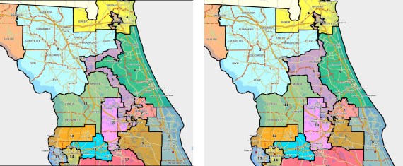
There is a map fight brewing in Florida. Florida legislators completed their hasty fix of a congressional redistricting map in an attempt to address the concerns by Circuit Court Judge Terry Lewis, who said the map violated a constitutional ban on partisan gerrymandering. Click below for a fun read.
The Health and Medical Geography Specialty Group (HMGSG) invites current undergraduate and graduate students to submit their work to the specialty group’s annual Peter Gould Student Paper Competition. The competition is meant to promote written scholarship by students across the field. Single-authored papers from any medical, health, disability and/or health systems related topic are encouraged.
The deadline for submitting an extended abstract is November 2, 2014.
More information here.
Though the prize is only $100, having your name associated with Peter Gould’s would be a very good thing for an up-and-coming student’s career!
And while you are at it, join the AAG!
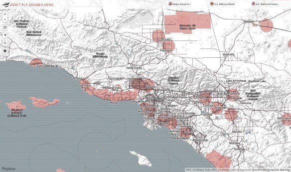
This interactive map represents areas where it is not permitted to fly drones due to current FAA regulations. Brought to you by Mapbox.