Start the new year off right by attending a few GIS conferences. Check out our GIS Conferences page to see what is in store the first half of 2016 in California!
2016 GIS Conferences
Reply
Start the new year off right by attending a few GIS conferences. Check out our GIS Conferences page to see what is in store the first half of 2016 in California!
If you are into creating your own apps that run on many platforms, then AppStudio for ArcGIS might be for you. ESRI has release version 1.0 and some of the highlights are:
For more info and to try AppStudio, see their blog post here.
ESRI has announced that ArcGIS 10.4 prerelease software for Desktop, Server, and Engine is now available for you to download, install, and test. They do stress it is for testing purposes only, so I would not use it in production.
Some highlights are vector tile layers, Portal for ArcGIS Map Viewer includes analysis tools, and improved enterprise readiness with ArcGIS Server and Portal. Also, ArcGIS Pro 1.2 is currently in beta. For more info about the release, see their blog post here.
UPDATE 2/22/2016: The ArcGIS 10.4 release is now available.
If you are planning on giving that wonderful flying machine to someone for Christmas, make sure they know that there is a string attached. The owner – whether it’s a new purchase or a drone that’s been flying for years – will have to register a name, a physical address and an email address with the FAA. Existing owners will have to register by February 19, 2016, and new flyers will have to register before their first flight.
You are required to register a drone if it weighs more than 9 ounces. Registration opens December 21 and is free through January 20 (the credit card transaction will confirm the owner’s identity and the fee will be refunded). After that, the FAA will charge $5 for registration. You must be at least 13 years old to register, or someone older must register for you. The registration is good for 3 years.
Oh, and the registration rule excludes “paper airplanes that are not linked to a system”, so a paper airplane that weighs more than 9 ounces does not need to be registered unless it has a motor and remote attached!
And the FAA plans on enforcing their rule. “Failure to register an aircraft can result in civil penalties up to $27,500,” the rule states. “Criminal penalties for failure to register can include fines of up to $250,000”.
Merry Christmas kids!

A scientist from NASA’s JPL in Pasadena says the long-awaited effects of El Niño will be felt soon in Southern California. Break out your kayak!
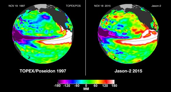
Yes, El Niño is on it’s way to Southern California. This particular one will bring a colder than normal December along with above average rainfall. The following article states that this December it will start out dry, but the back to back storms will increase as the month goes on. The storms are projected to be between December 17-20 and the next set before or on Christmas. Click below to read more.

Google Maps is now available offline. That means on your Android you can select an area to download from your phone and use it to navigate offline in areas that you don’t get good coverage in. And better yet, Google Maps can switch seamlessly between offline and online. Click here to read more.

GIS Day is Wednesday, November 18th. If you are looking for a site to visit, check out this interactive map for the SoCalGIS area (and beyond).

Location data from gisday.com.
Free webcast today, starts at 11am PST! Hurry and sign up!
Southern California’s Shrinking Salton Sea: Mapping, Managing and Mitigating New PM10 Air Pollution Sources
Abstract:
The Imperial Irrigation District (IID) Water Conservation and Transfer Project includes a long-term transfer of up to 303,000 acre-feet of water annually from IID to the San Diego County Water Authority, and the Coachella Valley Water District. The Water Transfer Project, along with other factors affecting Salton Sea inflows and water balance, will result in accelerated exposure of the Salton Sea floor. As the Sea continues to recede, there is potential for windblown dust emissions from the exposed dry lakebed (the playa). A significant portion of this windblown dust is PM10 (particulate matter with an aerodynamic diameter of 10 micrometers or less). PM10 are approximately 1/7th the thickness of a human hair, are small enough to be inhaled, and represent a potential human health risk.
The Salton Sea Air Quality Program is focused on monitoring and mitigating dust emissions from exposed Salton Sea playa. Remote sensing is a key component of this program, and will be used to map playa surfaces, vegetative cover, and active dust source areas. Learn how satellite, aerial and UAV images all contribute to this effort and how they are being processed using Trimble eCognition image analysis software. The presentation will also discuss dust control pilot projects, such as Surface Roughening, and the remote sensing techniques used to inform design and evaluate dust control effectiveness.
The California Environmental Protection Agency released a study that identifies areas across California experiencing hotter summer temperatures as a byproduct of urban development.
Urban areas have higher temperatures during summer compared with adjacent rural communities, a phenomenon known as the urban heat island. Heat islands are created by a combination of dark pavement and roofs that absorb heat, heat-generating activities such as engines and generators, and the absence of vegetation that provides evaporative cooling.
While the phenomenon is well-known, the study for the first time creates an Urban Heat Island Index (UHII) to quantify the extent and severity of the heat island effect for individual cities throughout the state. The study found temperature increases ranging from a few degrees in small cities and coastal areas to as much as 19 degrees on average over a day in large, inland urban areas.
Click below to read the report on how the Urban Heat Island Index was created and view the maps and data for different urban areas.

