Mapping the Nation: Building Smart Government with GIS

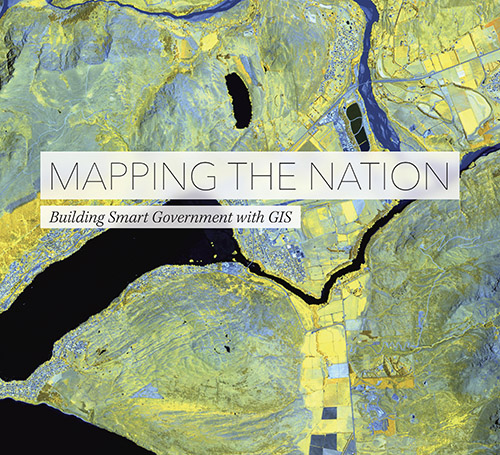
Mapping the Nation: Building Smart Government with GIS, a new book from ESRI, illustrates the many ways government uses maps created with geographic information system (GIS) technology to create safer, healthier, and more resilient communities.

This is the 6th book in ESRI’s Mapping the Nation series.  Chapters of the book are devoted to over 100 maps related to public safety, public policy, national mapping and statistics, education, health, the environment, and humanitarian work.

mappingnation_lg

Finally: Tallest Building in LA Gets an Observation Deck … and Skyslide!

The US Bank Tower in downtown LA (formerly Library Tower and First Interstate Bank World Center) is a 73 story, 1,018 foot tall skyscraper at 633 West Fifth Street and is the tallest building west of the Mississippi River (11th tallest in the US).  The building was constructed from 1987 to completion in 1989.

For many years I wondered why the tallest building in downtown LA never had an observation deck.  It was a bummer not to have one, especially on our tallest building!  But finally in July 2014, the owners of the skyscraper announced construction of an observation deck on the 69th and 70th floors, a restaurant on the 71st floor, and a glass slide outside to slip from the 70th floor to the 69th!

It should all be ready for you to try out by mid-2016.  Check it out!

towerslide

And if you wait until 2017, the new 73 story Wilshire Grand being constructed now will have its own sky-high observation deck and restaurant, plus an infinity pool on the rooftop!

ESRI Goes Big With SGELA

ESRI has supersized their Small Government Enterprise License Agreement (SGELA) which now includes local governments serving populations up to 250,000.

With an ELA, you have access to ESRI’s core products (Desktop, Server, Engine, Runtime) and extensions, with as many installs of the software that you need.  You also get an ArcGIS Online account for your organization, Portal for ArcGIS, CityEngine, access to ESRI Developer Network (EDN), Virtual Campus dollars for web training, instructor-led training discounts, and User Conference passes.  All for a pretty reasonable price per year for 3 years.  For example, Tier 4 runs about $50,000 per year.  Get your SGELA today and start expanding your organization’s access to GIS services and products!

World Geocoder for ArcGIS

ESRI has released World Geocoder for ArcGIS. World Geocoder for ArcGIS enables users to securely map global addresses behind a firewall so that sensitive data is never exposed.

World Geocoder for ArcGIS has several key benefits for organizations in addition to protecting sensitive data. It includes an API that can be used to add geocoding capabilities to ArcGIS apps and custom apps. World Geocoder for ArcGIS has been designed to geocode addresses from multiple countries, using a single locator, for a flat, fixed price.  Licenses come in Basic (250 million geocodes per year), Standard (3 concurrent batch jobs), and Advanced (8 concurrent batch jobs) levels.

Homeland Infrastructure Foundation-Level Data

The Homeland Infrastructure Foundation-Level Data (HIFLD) website, HIFLD Open, provides National foundation-level geospatial data within the open public domain that can be useful to support community preparedness, resiliency, research, and more.

HIFLD Open represents the initial evolutionary first step to provide online access to HIFLD Data. HIFLD Open provides publicly available datasets previously contained in HSIP 2015. These 270+ public domain datasets consist of both re-hosted public domain data AND when possible, live pointers to dynamic web services direct from the source. Data is available for download in a variety of formats to include: CSV, KML, Shapefiles, as well as access to APIs – such as GeoJSON, and GeoService.

Please note that in alignment with a recent vote by members of the HIFLD Subcommittee, the release of this new data portal represents a new branding and packaging approach to the HIFLD product line. The legacy term ‘HSIP’ is now represented by Homeland Infrastructure Foundation-Level Data. For questions or additional information related to this announcement, please do not hesitate to contact the HIFLD Support Team at HIFLD@hq.dhs.gov.

Geocortex User Group Meeting March 22nd

Mark your calendars, the next Southern California Geocortex User Group Meeting will be held March 22, 2016 from 1-4pm at the City of Burbank.  The meeting room address will be:

Burbank Community Services Building
Conference Room 104
150 N 3rd St
Burbank, CA 91502

Coffee and refreshments will be provided.  Parking details soon.

Join fellow Geocortex users, administrators and partners for interactive discussions and presentations.

Tentative agenda:

  • What to expect from the upcoming releases of Geocortex Essentials 4.5, Geocortex Viewer for HTML5 2.6 and Geocortex Mobile App Framework 2.0. This release is packed with dozens of new features and effectively closes the feature gap with our Silverlight viewer.
  • A demonstration of the major improvements made to our mobile architecture; we’ve simplified the way clients deploy disconnected Geocortex applications for users in the field.
  • A Geocortex user presentation.

To attend, please register here.

Interactive Tours of New California National Monuments

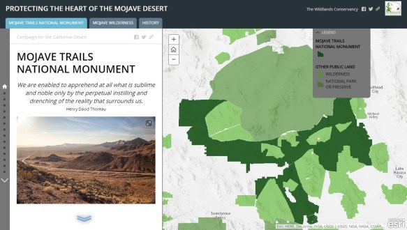
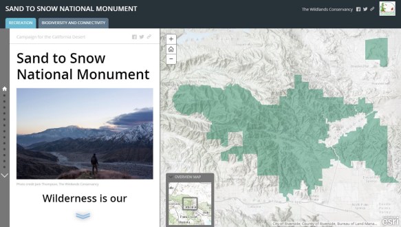
On February 12th three new areas were designated as national monuments in the California desert: Mojave Trails National Monument, Sand to Snow National Monument, and Castle Mountains National Monument.

Encompassing nearly 1.8 million acres of public lands, these new monuments are the culmination of decades of hard work and collaboration between government, conservation organizations, and local communities.

The Wildlands Conservancy played a major role in the creation of the Mojave Trails National Monument and Sand to Snow National Monument.  For the last 20 years they have acquired significant landscapes and saved them from development while stitching together California’s largest nature preserve system.

So you can better understand the new monuments, The Wildlands Conservancy has created two interactive tours of the Mojave Trails National Monument and Sand to Snow National Monument.  Check them out and go visit soon!

1on-zzint5foyuo4zaismbw

18qvjgjxwmnwnrxycfgxqtw

ArcGIS 10.4 Now Available

The ArcGIS 10.4 release is now available for all who have current licenses.  You can download the software from your my.esri.com account.

The new release includes new geoprocessing tools and updates, Python 2.7.10 with additional third-party libraries including SciPy, pandas, Sympy, and nose, and other updates to Mapping, Editing, Geodata/Geodatabases, and Network Analyst.  For more info, visit the 10.4 What’s New page.

PostgreSQL Client Libraries for ArcGIS 10.3

After installing a PostgreSQL database to be used by our 10.3 version of ArcGIS Server and Desktop, I was looking for the PostgreSQL client libraries to install on my Windows machine.  And guess what?  There were none!

In the installs I could see the usual ones for Oracle and SQL Server, but nothing for PostgreSQL for Windows.  How am I going to use ArcCatalog to create a new Enterprise Geodatabase in PostgreSQL?

Digging around on the internet revealed that it was not needed anymore.  As explained in the ArcGIS 10.3 documentation, ArcGIS 10.3 Desktop, Server, and Engine now contain the necessary PostgreSQL client libraries.  You can now connect directly from ArcCatalog to a PostgreSQL database from ArcGIS 10.3 without having to install those pesky client libraries!

Think about that for a moment.  If you have to install ArcGIS Desktop on a bunch of user workstations, you don’t have to install the PostgreSQL client libraries as well.  It will just work.  That saves a lot of time for sure.

And think about this one … if ESRI is making sure PostgreSQL databases will work out of the ArcGIS box, what direction are they leaning toward for future Enterprise Geodatabase implementation?  They did not choose Oracle or SQL Server.  Think about that.