Which Way Are Things Going?

The United States is experiencing the fourth wave of COVID-19 infections, due to the Delta variant of the virus. The mutation with a coinciding spike in cases was expected, but the rampant nature of the spread across the country poses many questions. First and foremost is, Where do I need to be especially careful?

The interactive map “Which Way Are Things Going?” gives a county-by-county view of active cases for a week-by-week perspective on COVID-19 trends. The map aims to provide accurate and actionable information for everyone, with data from state level to county level that makes it easy for anyone to zoom in and see the trends that will help them make decisions about when and where to better safeguard their health and that of their family.

Click below to view the story map.

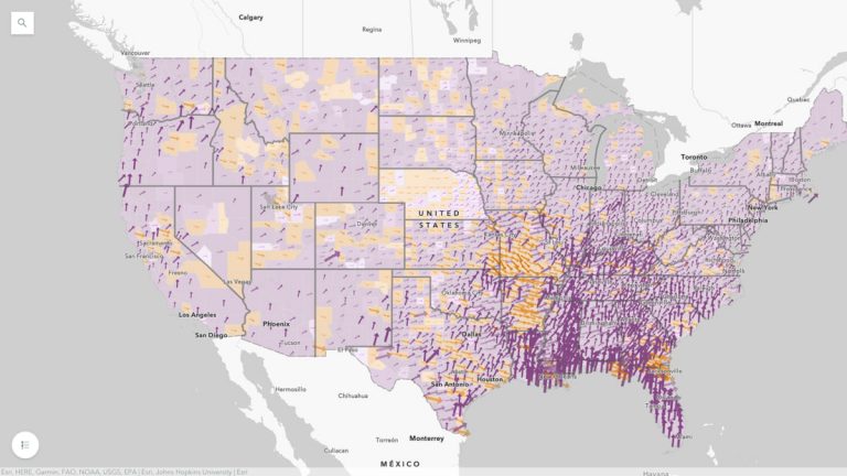
By the way, the source map is also available in ArcGIS Living Atlas for your use in your own apps, dashboards and story maps.

SCAG’s Regional Data Platform

Professor Steve Goldsmith of Urban Affairs at Harvard’s Kennedy School interviews Rex Richardson, the president of the Southern California Association of Governments (SCAG), and Darin Chidsey, SCAG’s chief operating officer. One of Richardson and Chidsey’s biggest projects is the creation of a Regional Data Platform that will serve as a data sharing and visualization platform for all of SCAG’s member cities.

Transcript available here.

Open Access to Key Federal Geospatial Data

Working with federal agencies, ESRI is opening up access in ArcGIS Online to dozens of high-priority, high-demand national data layers, often referred to as A-16 data. These include cartographic boundary files and demographic data from the US Census Bureau; National Agriculture Imagery Program (NAIP) data from the US Department of Agriculture (USDA); and the National Inventory of Dams (NID) database, managed by the US Army Corps of Engineers. Click below to read more about it!

What Should City Managers Know About GIS?

I’ll be doing a GIS (and probably census) presentation to a group of city managers in a few weeks. What do you wish city managers knew about GIS? What is on the horizon they should be aware of? I’ve done many of these presentations over the years and would really like to hear others’ ideas. Don’t worry, I won’t tell them who said what! You can email me at cc.waite@lomitacity.com. I’d be happy to share the list.

Barry

Imagery MOOC

ESRI has a new massive open online course (MOOC) on Imagery. If you’re interested in test-driving ArcGIS Image for ArcGIS Online, ESRI’s new cloud-based imagery product, or seeing how to bring drone-captured imagery into ArcGIS Pro for visualization and analysis, this no-cost course is a great opportunity. The course is from August 11 to September 22, 2021 and is free. Check it out and sign up!

USGS lidar webinar: Costsharing in FY2022

The USGS National Geospatial Program is hosting a public webinar to provide information about the 3DEP Broad Agency Announcement (BAA) solicitation for cost sharing assistance in lidar projects for the upcoming Federal 2022 fiscal year. If you have interest in funding or are in the early stages of coordinating a lidar collection for your area of interest, this webinar will give you the information you need for FY2022 and beyond.

The webinar will be held on August 11, 2021. Click here for more info and to register.