Just in time for Halloween, Esri’s “Where Are the Bodies?” story map documents the final resting places of some of the most famous (and infamous) actors, artists, authors, and criminals. Check it out!


Just in time for Halloween, Esri’s “Where Are the Bodies?” story map documents the final resting places of some of the most famous (and infamous) actors, artists, authors, and criminals. Check it out!
Abel Buell’s New and Correct Map of the United States is showcased in the ongoing Library of Congress exhibition “Mapping a New Nation”.
This landmark map of extraordinary significance to the historical record of the United States was published by Abel Buell in 1784. Notably, this is the first map of the newly independent United States compiled, printed, and published in America by an American. Additionally, it is also the first map to be copyrighted in the United States. Only seven copies are known to exist and survive in major institutions in the United States, the United Kingdom, and Spain. The copy on display is considered to be the best preserved of all extant editions and was officially deposited with the Library by Mr. David Rubenstein in January 2010. Check it out!

Want a custom handcrafted wood-inlay map? Zoom into an area on a map and this company will create a woodcut map of that area for you. Choose type of wood combos for land, water, parks, and roads, and also customize the border, data source (Google or OpenStreetMap), road detail, and if you want to include hospitals, schools, and buildings. Check it out!

Remember, only 96 days until Christmas! Or less if you are reading this later.
For at least a century, the moving rocks of Death Valley have presented a puzzle, and researchers have been trying to solve it since 1948. The rocks, some of them boulders weighing more than 600 pounds, show signs of movement across the desert floor by leaving long trails behind them.

Explanations including dust devils, flooding, hurricane-strength winds, and even UFOs have been offered, but the mystery was finally solved when researchers caught the rocks in the act!
Check out the National Geographic article and watch the video below.
Most people do not realize that the original vision of Walt Disney World included a plan for an Experimental Prototype Community of Tomorrow (E.P.C.O.T.), known today as Epcot.

E.P.C.O.T. was Walt Disney’s one of a kind project composed of several elements which included a prototype community, an industrial park, an airport of the future, a Disneyland type theme park, transportation systems, and much much more.

All these elements were imagined by Walt Disney and his staff with new and advanced designs and technologies. The project was conceived between 1962 and 1966 and even if it did survive a couple of years it was stopped in the mid 70’s and never developed. Some elements did survive in the Walt Disney World resort as we know it today, but so much more was planned. Unfortunately, the project lost it’s main energy: Walt. Walt Disney died just two weeks after filming the “E.P.C.O.T. film” in 1966, a promotional film created for the media and investors. The film is a great Disney landmark since it’s the last movie of Walt Disney alive and since it’s content is Walt Disney’s last and unbuilt dream … E.P.C.O.T.

Check out the website and watch the film. Walt Disney was very focused on transportation and how to move people and goods around. If you are into urban planning and design or transportation, this piece of history will be very interesting to you! Click below to check it out.

Almost looks like a GIS map!
Over the years, making a globe is still mostly a manual process.
Making a globe in 1935:
Globe making in 1955:
Making a globe today:
It was just a matter of time! Check out the bars you can get to via Metro’s rail system.
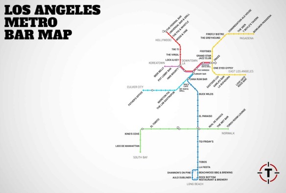
The bars are within a 10 minute walk from the station.
Can you identify the book from its map? Click the map below and try the quiz!

xx
Stanford University Library has started preparations to receive the David Rumsey Map Collection. David Rumsey began gathering his map collection over 25 years ago and announced in 2009 that it would be donated to Stanford. According to Rumsey, technology has risen to the forefront in the University’s plans for the collection and the map center. Computerized tools, such as video and touch-sensitive walls, will be available beside the physical maps. ArcGIS will also be incorporated.

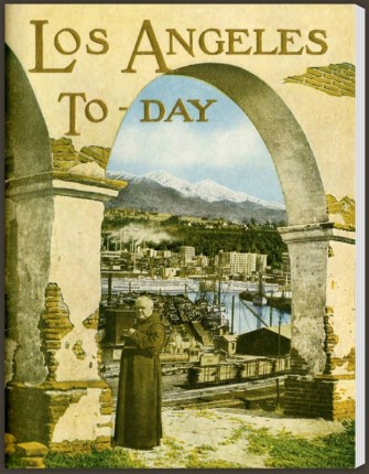
For centuries, “California, here I come!” has been a popular rallying cry for fortune seekers setting course for the Golden State. This collection from the California State Library brings together a dozen travel brochures from 1870 to 1940 that document this most alluring state. Check out “Los Angeles To-Day”, which was originally published in 1924 to promote all aspects of SoCal.