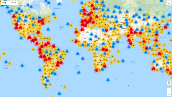
Robocalls

Mad about robocalls?  It seems to be increasing on my cell phone every year.  In 2018, a record 48 billion robocalls were placed to phones in the US.  That works out to 1,500 robocalls per second!  Check out this map on robocalls and read the Consumer Reports article about it and how you can start the wave to stop it.

robocalls


Left and Right Hand Side Driving

Most countries drive on the right hand side of the road.  Why do some countries drive on the left hand side?  The historical account is that most countries which were British colonies kept to the left hand side of the road.  British horseback riders used to ride on the left hand side, thus keeping their right arm free to offer greetings or draw their sword.  Similarly, the USA teamsters used to sit on the left hand horse while driving a wagon and therefore kept their right hand free for whipping the other horses, however, later they decided to start driving on the right so that they could see the passing wheels of other wagons and avoid collisions.

Another fun fact, Sweden changed from the left to right hand side in 1967.

“Daylight Saving” Time?

Once again “Daylight Saving” is upon us.  I put that in quotes because nothing is being saved … more like stolen!

timezones

You heard the expression “robbing Peter to pay Paul”?  That is what Daylight Saving Time does, it pushes your state into the time zone to the east, so California moves into the Mountain Time Zone.  But nature does not care, the sun will rise and set as usual, however because you shifted your clock to the east it GIVES THE ILLUSION of setting later in the day … and rising later as well!  If you are a morning person, dealing with that extra darkness in the morning really sucks!

Continue reading

Top Searched Trader Joe’s Items

Finally, a Trader Joe’s map of food items!  This map shows the most popular item that was searched for on Google by state.  The winner?  13 states favored Sweet Chili Sauce.  California was the only state that favored Unexpected Cheddar.  Click below to read on!

traderjoesitems

This map is even more interesting because I could not find any Trader Joe’s locations in Montana, Wyoming, North Dakota, South Dakota, Mississippi, Arkansas, West Virginia, Hawaii, and Alaska using the Trader Joe’s location tool.  I guess people are buying on Amazon and Ebay?

Internet Bird Collection

If you like birds, the Internet Bird Collection (IBC) is an excellent place to spend some time.  The IBC is an online audiovisual library of videos, photos, and sound recordings of the world’s birds created with the ultimate goal of disseminating knowledge about the world’s avifauna.  You can explore multimedia materials and recordings of thousands of bird species crowdsourced by birdwatchers around the world, with their species identifications cross-checked by trained ornithologists.  This vast collection can be searched and filtered by family name (common or scientific), country, keyword, date, and more, and each media entry includes a location map and shows other media recorded nearby.  Those interested can create a free account and contribute their own bird photos, videos, and sound recordings.  Check it out!

internetbirdcollection

Atlas of Endangered Alphabets

The Atlas of Endangered Alphabets is a fascinating project that anyone curious about written languages can enjoy and learn from. Visitors to the atlas can browse dozens of writing systems by their place of origin via the interactive map. While many of the languages represented in the atlas are spoken today, their written forms may have declined in use or have only recently been developed. Each language has its own page with images, profile, and links to additional resources. Check it out!

atlasofendangeredalphabets

Whale Mapping

Most of us using GIS today do not get to do much mapping of whales, but back in the mid 19th century the American whaling trade was big business and you needed to know where the whales were.

Check out this innovative map from 1851 showing the distribution of several different species of whales, identifying each with a combination of color and pictorial symbols.  The map shows at that time that the Pacific Ocean was the primary habitat for whales.  The Atlantic Ocean was not because the whale resources there had been terribly depleted.  Check it out!

whalemap