Here are a few notes I jotted down while at the Road Ahead workshop for ArcGIS Desktop.
10.5 at the end of the year Continue reading

Here are a few notes I jotted down while at the Road Ahead workshop for ArcGIS Desktop.
10.5 at the end of the year Continue reading
After watching a drone fly around in a cage at the ESRI conference, I decided to head upstairs to the technical workshop about creating vector tiles. Here are a few things about them that you should know. Continue reading
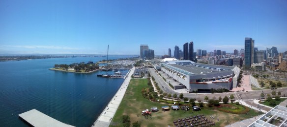
The 2016 ESRI User Conference got off to a great start today in beautiful downtown San Diego.
Instead of giving you a blow by blow of what happened today in the Plenary, you can just watch it here.
Do you like maps? Do you like lamps? If you said YES to both, then you must get a map lamp! You know you want one!
4 out of 5 GIS Analysts think map lamps are cool. Even Chuck Norris approves map lamps.

So go get yours today! 🙂

Our next stop for California Friday is actually many locations. July 4th will be here soon and that means Fireworks! The fireworks app I have used for the past few years has been updated once again. This year I added Riverside County. If you love fireworks and want to find out where you can legally buy and shoot them off in SoCal, check out the app!
You can view cities in LA, Orange, Ventura, and Riverside County that allow the sale and discharge of fireworks. Included are days and times when fireworks will be sold and when you can light them up, as well as links to city web sites and telephone numbers. Data was collected from municipal codes, web sites, and/or contacting each city. Enjoy!
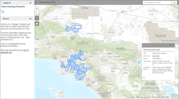
For a list of 296 communities permitting state-approved fireworks in California, check out the California Fireworks Newswire website.
Q: When will ArcGIS Pro support parcel editing?
A: ArcGIS Pro supports simple feature editing now and is adding topology support at 1.3. We expect full parcel support to be available next year.
Each year ESRI creates a set of questions and answers for the User Conference in San Diego. This information is designed to help you understand the latest enhancements to ESRI technology, emerging trends for GIS for your industry, and the road ahead for ArcGIS software. Check it out.
Check out this article about Tom Harrison, a Californian cartographer who started his own mapmaking business in the 1970’s. His maps are made for hiking, backpacking, and mountain biking in the parks and wilderness of California. He explains what goes into a good map and why making one can take nearly two years.
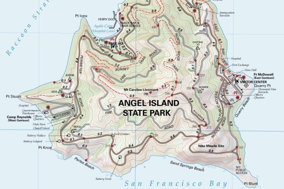
You can order his maps from here.
The 2016 ESRI User Conference in San Diego is just a week away. If you are using or plan to use some of the offerings in the ArcGIS for Local Government suite, check out these technical sessions and demos during the conference.
Also, you can check out the conference schedule to plan your week.
If you are looking to get more involved with GIS in California, please consider running for the Vice-Chair position on the California GIS Council. The Vice-Chair assists the Chair in leadership and administration of the Council, and will assume the role of the Chair at the expiration of the sitting Chair’s term. The nomination period has been extended to June 22.
If you plan on attending the ESRI User Conference in San Diego at the end of the month, you might want to know that they are brining back free GIS data health checks. You can bring in a sample of your data in either a file or personal geodatabase to the conference and an ESRI industry expert will perform a diagnostic on your data to assess its overall quality. For more info, click here.
