Looking for a unique map gift? How about a textile map from this Wisconsin textile artist? Check it out!


Looking for a unique map gift? How about a textile map from this Wisconsin textile artist? Check it out!
Looking to do a little prediction mapping using logistic regression in ArcGIS and the R environment … I thought so! This stuff makes my head ache, however if you are interested there is a series of videos that will step you through it. Check it out!

Also, check out this article about ESRI and R support.
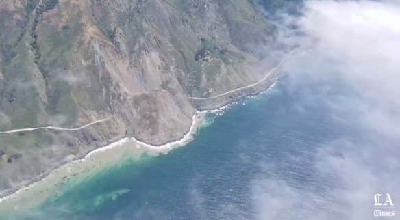
For those of you that like to drive PCH, it might be a while if you want to go past Big Sur. On Saturday night, a massive new landslide has buried PCH under 40 feet of rock and dirt in an area called Mud Creek. Check out the video and article below.
Like to plan ahead for the 2017 ESRI User Conference in July? The agenda is now available for you to plan out what workshops and events you will attend! Check it out.

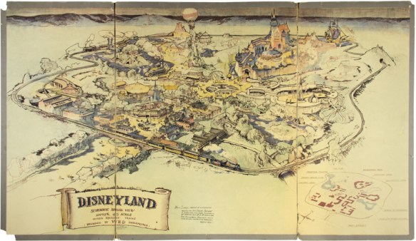
Have some extra cash? Maybe you would be interested in placing a bid for this original map of Disneyland, co-created by Walt Disney himself when the park was still in the inception phase. The map helped Walt and his brother Roy sell the park idea and make it a reality in Anaheim. For more info of the story and where the auction will be held, click below … and good luck!
And if you don’t have that kind of cash, maybe you would settle for this book instead? It’s a good one.

The book opens up from the middle, which is cool. For a look inside, check out this video.
For the past several centuries, cartographers have tried to find different ways to portray the globe on a two-dimensional map. Many of these attempts, including the Mercator projection, distort the true size of different countries and regions. As a result, many of us have false perceptions about the proportional size of different geographical areas.
Back in December 2013 I posted about using the field calculator in ArcMap to calc a field to the third word from another field. Since then, the comments section has been pretty active with questions and answers. I thought it would be a great time to expand on that with other nifty field calculator tricks that I have used over the years.
This one I use a lot. I have a field that contains parcel number data. In LA County, parcel numbers are 10 digit numbers that represent the assessor book (first 4 numbers), page (next 3 numbers), and lot number (last 3 numbers). I want to split them out into their own fields. Here is how I do it.
Looking for unusual maps? Check out this website that makes available to the public a collection of more than 800 examples of persuasive cartography, maps intended primarily to influence opinions or beliefs – to send a message – rather than to communicate geographic information. You can search for maps by subject and there are also links to download the high resolution image of each map.

The Center for Spatial Studies at UCSB will be hosting its annual spatial@local2017 Poster and Plenary Session at Corwin Pavilion on Thursday, June 8, 2017.
This year the theme is Environmental Conflict Resolution in the Santa Barbara Channel and will feature speakers from NCEAS and the Channel Islands National Marine Sanctuary.
You can participate in this event, either as poster submitters, or as attendees to the plenary and viewers of the posters. Although the session has a theme, posters on any topic that addresses spatial analysis will be accepted.
For more info and to RSVP, click here.
Are you looking for nautical charts? NOAA’s paper nautical charts are available as “print on demand” up to date to the time of purchase. You can also download charts in PDF format for free.
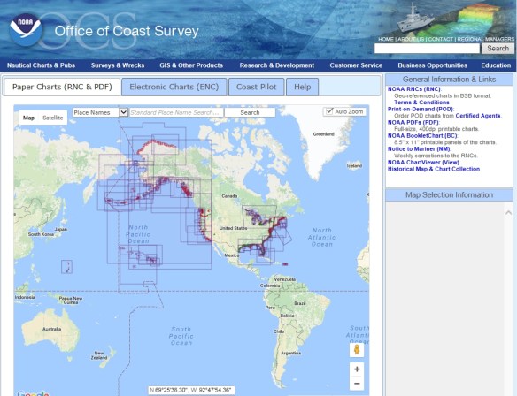
Looking for open ocean and international waters charts? They are produced by the National Geospatial-Intelligence Agency (NGA) and available through vendors as “print on demand” products.
