Unknown's avatar

About socalgovgis - Michael Carson

Michael Carson, GIS Manager (retired) for the City of Burbank and President of Southern California Government GIS User Group. Currently teaching GIS at College of the Canyons in Santa Clarita.

NAPSG Los Angeles Regional Summit

NAPSG Foundation is holding a one-day Los Angeles Region Summit on September 15, 2014, in Los Angeles, California.  Just one block from the historic Union Station in downtown Los Angeles. This event will convene current and new NAPSG partners from the Los Angeles Region and across Southern California, from all public safety disciplines and levels of government.

The Summit will provide you with an opportunity to learn about the status of Public Safety GIS in the Los Angeles Region and to interact with other public safety officials and GIS professionals.

Who Should Attend? Operations and technical public safety officials, across all disciplines, who are interested in learning more about the requirements and application of GIS in day-to-day public safety operations.  Including:

  • Public Safety – Emergency Managers, Fire Service, EMS, Law Enforcement, Fusion Centers
  • Search & Rescue Coordinators
  • GIS Coordinators
  • Transportation Agencies
  • Public Safety & Homeland Security Officials
  • GIS Analysts, Specialists, Managers
  • IT Support Personnel
  • Industrial Emergency Responders

And all other Public Safety & GIS Personnel

Agenda topics will include:

  • Geospatial Information Sharing
  • US National Grid
  • GIS for Next Generation 911
  • Data Interoperability
  • Brush Fire Operations
  • Search & Rescue
  • Regional GIS Infrastructure
  • …and other technical and operational topics

Registration will open in early August, and space will be limited.  There is no cost for public safety and other government officials.

Where & When
The California Endowment
1000 N Alameda St
Los Angeles, CA 90012
September 15, 2014, 8:30-4:30pm

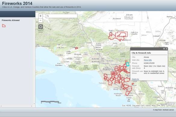
Fireworks 2014: Where to Buy and Light!

It’s that time again … Fireworks!  This year the fireworks app has been expanded to include cities in Orange County and Ventura County.  Included are days and times when fireworks will be sold and when you can light them up, as well as links to city web sites and telephone numbers.  Data was collected from municipal codes and/or contacting each city.  Enjoy!

fireworksapp2014

SoCal URISA Hosts an Open Source Workshop

SoCal URISA hosts an Open Source Workshop With Jeff Johnson
Palomar College: 1140 W Mission Rd, San Marcos, CA 92069
Date: 28 Jun 2014 8:00 AM PDT

You have probably heard about open source geospatial tools. Here is the chance to experience them under the direction of experts. Bring your laptop and dive into some of the most powerful, widely used and innovative tools in this area.

Open-Source developer, Jeff Johnson, will lead us into a high level look at the ecosystem of Open Source geospatial tools from QGIS on the desktop to GeoServer and PostGIS on the server and the web application frameworks used to deliver applications using these services on the web. We will then dive deeper into raster and vector spatial analysis on the desktop with QGIS and look at the various freely available QGIS extensions and plugins that GIS practitioners can use in their own projects and workflows. The course material will be drawn from the following 2 workshops. http://workshops.boundlessgeo.com/suiteintro/ and http://docs.qgis.org/2.2/en/docs/training_manual/ and users are encouraged to install the tools ahead of time by downloading from http://boundlessgeo.com/solutions/opengeo-suite/download/ and http://www.qgis.org/en/site/forusers/download.html

We will host a light continental style breakfast along with coffee and a sandwich lunch.

Location: Palomar College, San Marcos in the Natural Science Bldg.  NS-127 (GIS Lab)

Directions and parking pass will be emailed out to registrants closer to the date.

Preliminary Schedule:

7:30 am – Registration opens, grab a light breakfast too.
11:30 am – Lunch
5:00 pm – Conclude Workshop

The workshop is Free for SoCal URISA members, otherwise purchase or renew your membership.

$30  Annual Fee
$10 Student Annual Fee

Please don’t forget to save you receipt from this event and use it towards your GISP credit.

Speaker Bio:

Jeffrey is a geospatial software engineer with 15+ years of experience building and delivering applications for the web. Jeff is a developer with a broad range of skills who can work at any level, from writing code and fixing bugs to managing complex projects and making architectural decisions while coordinating technical policy with corporate strategy. He spent the past 3.5 years working for Boundless (formerly OpenGeo) on GeoNode, GeoGit and various related open source projects and has given presentations and workshops on these technologies around the country and the world. Jeff is also deeply involved with the City of San Diego’s Open Data and Civic Technology initiatives. He is a graduate of Humboldt State University where he studied Geography, Cartography, Geology and Geospatial Technology.

Jeff can be reached at ortelius@gmail.com with questions about this workshop or for advice and consulting on projects leveraging open source geospatial tools.

More information and online registration: SoCal URISA hosts an Open Source Workshop With Jeff Johnson

Best regards, Southern California Chapter of URISA

National Weather Service – Impact Based Statistics

“In an ever-growing effort to provide valuable weather information — or just a vulgar display of automated GIS skills — the National Weather Service is tweeting out images that show how many people are impacted by severe weather. The exercise shows just how little of the United States is populated.”

Thanks goes to Peter King of iWater for pointing out this article.

2015 CalGIS Location Survey

Hey CalGIS folks,

We’re starting preparations for the 2015 CalGIS and I’m super excited. As mentioned during 2014 CalGIS, we want to get your opinions on a few things before we move forward with location selections. I really appreciate you taking the time to respond to this survey, it should take you less than 2 minutes. We’ll be closing the survey on June 18 so if you want a say, respond before then.

Here’s the link: 2015 CalGIS Location Survey

Thanks!

Christina Boggs
2015 CalGIS Conference Chair
Christina.Boggs@norcalurisa.org

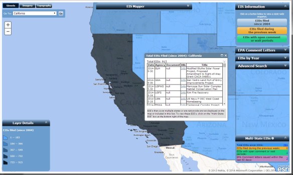
EIS Mapper

If you deal with environmental issues or if you work with planners who are developing sites, this website may be useful.

The EIS Mapper displays information for each state with data from EPA’s Environmental Impact Statement (EIS) Database.  Included are EISs filed since 2004 up to the present (previous week), statements with open comment or wait periods, and EPA comment letters.  Using the map application, you gain access to electronic copies of the documents.

The EIS Mapper is a valuable tool for environmental research, planning and municipal developers, property owners, legal research of companies and properties, and for anyone doing historical research on environmental related activities in the United States.  Check it out.

eismapper