ESRI has updated ArcGIS Online for March. One of the big ones is what they call Smart Mapping which include new ways to symbolize data, “smart” defaults, and data-driven workflows. Check it out.
What’s New in ArcGIS Online
Reply


ESRI has updated ArcGIS Online for March. One of the big ones is what they call Smart Mapping which include new ways to symbolize data, “smart” defaults, and data-driven workflows. Check it out.
Check out HistoricPlacesLA.org. It is the first online information and management system specifically created to inventory, map, and help protect the City of Los Angeles’ significant historic resources. It showcases the city’s diversity of historic resources, including architecturally significant buildings and places of social importance, as well as historic districts, bridges, parks, and streetscapes.
Thanks goes to Barry Waite at the City of Carson for pointing out this resource.
The Department of Geography at California State University Long Beach is accepting applications for our Master of Science in Geographic Information Science (MSGISci) degree program. The application deadline is April 1st; the FAFSA deadline is March 2nd (https://fafsa.ed.gov/).
Key Program Features: ▪ 1-year completion time (30 units). ▪ Schedule is designed to meet the needs of working professionals (courses are offered on weeknights and Saturdays) ▪ Tuition and fees are just under $20,000. Additional program details and application information can be found at www.beachgis.com.
Suzanne P. Wechsler, Ph.D.
Associate Professor
Department of Geography, California State University Long Beach (CSULB)
Director, Master of Science in Geographic Information Science (MSGISci)
After Google’s announcement that they were ending support of Google Maps Engine and their implied retirement of Google Earth Enterprise, as well as Google Earth Pro which is now free, ESRI has teamed up with Google to offer GME and GEE customers no-cost ESRI replacement software for a year (after that they pay maintenance). Also included is no-cost training and attending the annual User Conference at no cost.
Looking to get into web programming? io9.com has a great deal for you. They are offering 8 in-depth web programming courses. The bundle of courses cover HTML5, CSS, Java, PHP, MySQL, Objective C, Xcode, and Python. The best part is you pay what you want for them. Check it out! The offer is through stacksocial.com.
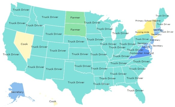
Check out this map from NPR’s Planet Money blog depicting the most common job in each state from 1978 to 2014. What emerges is a story of changing economic, demographic, and technological circles over a period of 36 years. There sure were a lot of truck drivers in 2004 … “puttin’ the hammer down on the super slab”!
California Geographic Information Association (CGIA) is hosting their fourth annual CGIA GeoSummit at UC Merced, Friday March 13, 2015.
This event brings together state and regional GIS experts, educators, graduate students, and faculty using GIS in their research, in addition to community members with an interest in GIS. The event this year features speakers from all walks of GIS to share their work, the latest in GIS technology, student presentations, and a map gallery. For more info, visit their website.
New to GIS? New to QGIS open source software? Check out this free self paced course from Del Mar College introducing you to GIS and QGIS software. The course opens today.
Topics covered in this course include GIS, cartography, remote sensing, and spatial analysis through a series of lectures and hands-on computer-based exercises. This course is designed to be used as a stand-alone course to complement other disciplines or as an entry level course into a geospatial program. Course content is based upon the United States Department of Labor’s Geospatial Technology Competency Model for entry level geospatial occupations, including Geospatial or GIS Technicians and Technologists.
If you consider yourself knowledgeable in GIS, but want to know more about QGIS open source software, visit the QGIS website and follow the training manual.
New to ArcGIS Pro? Take advantage of ESRI’s free online training to learn the key capabilities of the software:
ArcGIS Pro interface
Editing
Analysis
Sharing projects
ArcGIS Pro licenses come with your ArcGIS Desktop licenses. You will also need an ArcGIS Online Organizational account.
If you are looking for a school with the best overall Graduate Geography Program for a spatial career, check out this posting on Geographical Perspectives.

