Registration for the 2026 ESRI User Conference in San Diego is now open! Get registered and find your favorite hotel!


Registration for the 2026 ESRI User Conference in San Diego is now open! Get registered and find your favorite hotel!
The next Cambridge Seminar in the History of Cartography will be held via Zoom on Tuesday 18 November 2025 at 5.30pm UK time (9:30am PST).
The speaker will be Chris Lukinbeal, University of Arizona on Cinematic Cartography.
All are welcome.
Please register for the talk at https://buytickets.at/emmanuelcollege/1929457 and the Zoom link will be sent to you.
**********
On a side note, this reminds me of a book I purchased a while back, Cinemaps. You should pick one up for a Christmas gift! -mike

The California Geographic Information Association will have their annual meeting on Thursday, November 20th 12-1:30pm.
For more information visit https://cgia.org/2025/11/join-us-for-the-cgia-annual-meeting-on-november-20-2025-12-130-pm/
GIS Technician – City of Hesperia
GIS Supervisor – City of Corona
Enterprise GIS & CAD Team Manager – Los Angeles
BIM/GIS Coordinator III – Pasadena
Principal Instructor ArcGIS Enterprise – Redlands
GIS Technician/Analyst – Anaheim
GIS Mapping Technician – San Marino
Engineering Technician I (GIS) – City of Torrance
We’re looking for an experienced GIS Analyst to join our talented and innovative GIS team. While the posting mentions both Analyst and Associate Analyst levels, our main focus is hiring for the GIS Analyst role.
The position is primarily remote, with one day per week required in office; however, daily in-office presence is expected during the initial onboarding period.
About the Role:
As a GIS Analyst, you’ll be an integral part of our high-performing team that builds and delivers innovative, technology-driven solutions to improve city operations and public services.
In this role, you will:
• Manage GIS integrations with business systems
• Develop and maintain complex GIS solutions
• Automate workflows to improve efficiency
• Collaborate with various departments and vendors to deliver GIS analysis and insights
We’re Looking for Someone Who Will:
• Be a technical problem-solver—curious, adaptable, and motivated by delivering solutions with real impact
• Demonstrate self-direction—able to manage timelines, make informed decisions, and communicate proactively
• Have strong experience in enterprise-level GIS, geodatabases, service publishing, and developing/maintaining web-based solutions with ESRI tools
• Balance independence with collaboration—remaining customer-focused and dedicated to providing excellent service at every step
A Note on Hiring:
To ensure fairness in hiring, our applicant review system anonymizes resumes during the initial screening. This means we see your skills and qualifications—without identifying details—helping us focus on what matters most.
Apply today:
https://www.governmentjobs.com/careers/carlsbad/jobs/5046581/gis-associate-analyst-analyst
Applications close on Wednesday, September 3.
Do you have 4 or more years of recent experience using ESRI GIS software? Do you have experience editing, analyzing, and managing GIS data in geodatabases? Do you have experience with GIS application development and implementation of related technologies? Can you work collaboratively with external and internal customers?
If so, the County of Ventura is looking for you to join their GIS Team in the Information Technology Services Department. Example of duties may include but not limited to:
Continue readingThe 2025 ESRI User Conference is wrapping up. The Thursday night party is at Petco Park this year … unfortunately you cannot run the bases!

If you have not seen the Plenary videos, you can view them here.
I would say the most interesting thing for me at the conference were the new AI Assistants in ArcGIS Pro. Be part of the beta program for 3.5. The 3.6 beta will be available in September 2025.
Another thing that was interesting was the soon to be available Google Photorealistic 3D Tiles in ArcGIS. Read more about it here.
Dear SoCalGIS,
Get ready to celebrate innovation in geospatial technology!
The California Geographic Information Association (CGIA) is thrilled to invite you to our annual **CGIA Awards Social**, where we will honor California’s most innovative geospatial projects and ideas.
This is a fantastic opportunity to join us for an evening of recognition, networking, and celebration with fellow professionals. We’re excited to announce that this year’s social is generously sponsored by **ParcelQuest**.
**Event Details:**
* **What:** CGIA Awards Social
* **When:** Tuesday, July 15, 2025
* **Time:** 6:00 PM – 8:00 PM
* **Where:** Revel Revel, 868 5th Ave, San Diego, CA 92101
Enjoy **complimentary food** throughout the evening, and be sure to arrive early – the **first 75 guests will receive a drink voucher!**
Don’t miss out on this exciting event. Please RSVP at cgia.org.
We look forward to celebrating with you!
Best regards,
Tracy Tober
CGIA CHair
On August 6th at 10:00 AM Pacific Time, USGS will host an informational webinar to provide an overview of the Fiscal Year 2026 (FY26) 3D National Topography Model (3DNTM) Data Collaboration Announcement (DCA) for the 3D Hydrography Program | U.S. Geological Survey (3DEP) and the 3D Hydrography Program (3DHP).
For more info and to register, click here.
Fireworks! Fireworks! Fireworks!
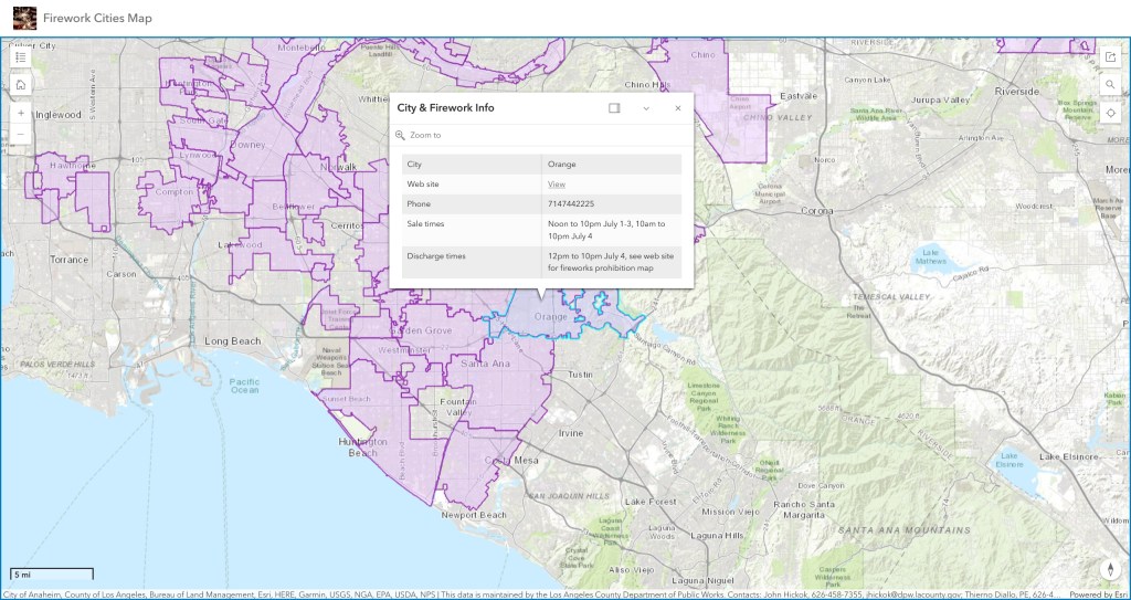
Yes, it is almost July 4th again and our famous SoCal Fireworks app has been updated for 2025.
For this year the City of Orange has joined the other cities that allow fireworks. Sadly the City of Carson and City of Inglewood decided to ban fireworks for this year.
Use the app to view cities that allow the sale and discharge of fireworks in LA, Orange, Ventura, Riverside, and San Bernardino counties. Included are days and times when fireworks will be sold and when you can light them up, as well as links to city websites and telephone numbers. Data was collected from municipal codes, websites, and/or contacting each city. Data provided as is. Some cities are allowing sales now. Check it out and be safe!