Interesting Voter Map

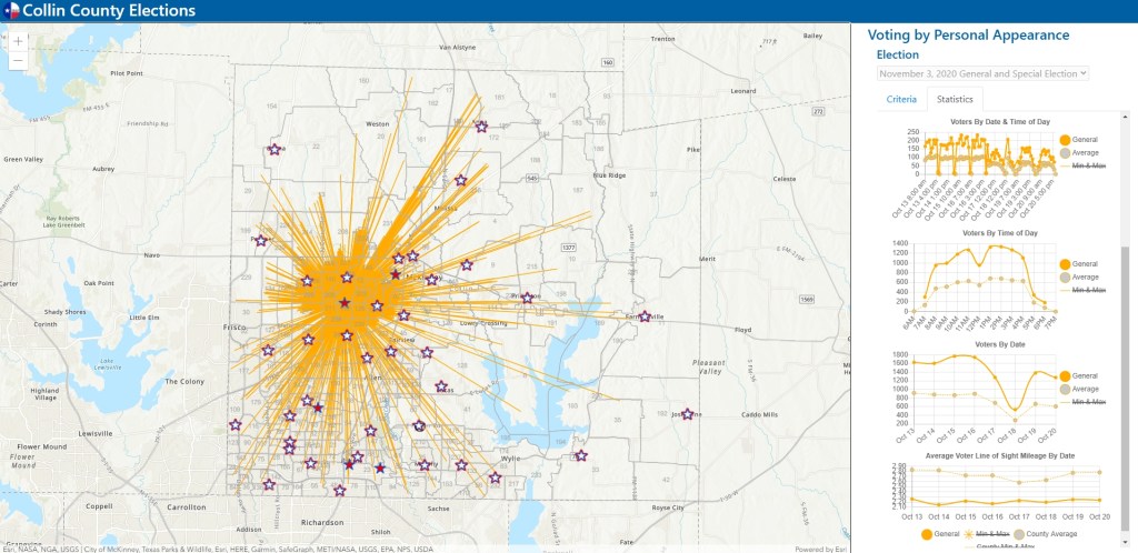
I found this one to be pretty interesting. It is an interactive map from Collin County, Texas. During early voting right now, voters can vote at any polling location. The GIS team there takes daily voter roster counts and displays a spider diagram for each voting center (when you click on one), showing you where voters are traveling from to each voting center. Statistics like voters by time of day and date are also displayed to the right. You can also change what voting days you want to look at. Pretty cool!

Outside Demo of Wingtra Drone

Looking to get outside for a few hours? Join us at a large area to social distance and watch Wingtra demonstrate the fixed wing vertical takeoff mapping drone starting at 10am Thursday October 15th above the San Antonio Dam, just 5 minutes from the Baseline offramp to the 210 freeway. Masks required.

Here is the 3 meter square location: https://what3words.com/unplanned.kings.nationals

And also let us know here so we can give any last minute updates if necessary: https://tinyurl.com/y48assbf

Hope to see you there!

Prof Warren Roberts
Rio Hondo College

A Year Along The Geostationary Orbit

Here is a cool video of a year through the distant eyes of meteorological satellite Himawari-8, from December 21, 2015 to December 21, 2016. The satellite observes Earth in geostationary orbit at 140.7 degrees East following Earth’s rotation by travelling at approximately 11068 km per hour at a distance from Earth at 35768 km. Check it out and look for the March 9, 2016 total solar eclipse!