Check out this article about the top 10 educational benefits for students who use GIS. Spoiler alert: it will help your career pathway!


Check out this article about the top 10 educational benefits for students who use GIS. Spoiler alert: it will help your career pathway!
Rio Hondo College GIS Courses are scheduled for both online and hybrid with field exercises this spring semester starting January 29th. Courses include Introduction to GIS, Intermediate GIS, (Surveying w/) Small Unmanned Aircraft Systems, Cartography, Crime Mapping and Geospatial Programming (Python) and our new course taught by instructor Sean Christian PE is the GIS for Public Works (GIS222).
For more information on GIS and Rio Hondo visit here https://page.riohondo.edu/gis/ and list of course schedule here https://gisteacher.wixsite.com/riohondo/spring2022
Have you registered for the 2022 ESRI User Conference? It’s back in San Diego! Hurry and register and get your favorite hotel.

So what’s new in ArcGIS Online? A whole bunch of enhancements and new stuff. Click below and check it out!
Every month, the Esri State & Local Connect webinar series brings you 45 minutes of content you need to know, from the people who are dedicated to helping you succeed with GIS. This month the team is taking a deep dive into imagery capabilities for state and local government.
The diversity and volume of imagery and remote sensing data are growing rapidly. Drone, aerial, and satellite imagery and other types of remotely sensed data are opening new frontiers in nearly every facet of government. In this webinar, we will showcase how the latest imagery capabilities can provide communities with greater insights into nearly every aspect of operations, from urban planning and natural resource management to event management and disaster response.
Click here for more info and to register. Past webinar recordings can be found there too.
There is a proposed revision to the Council’s Charter to change their name from the California GIS Council to the California GIS Community Forum, the Executive Committee to the Steering Committee, and other changes in the text to better align with how this group functions. See the changes here.
The revisions were drafted by the Charter Review and Strategic Plan Workgroup.
Check out this map of Google autocomplete results from the typed in statement “Why is [state] so …”.
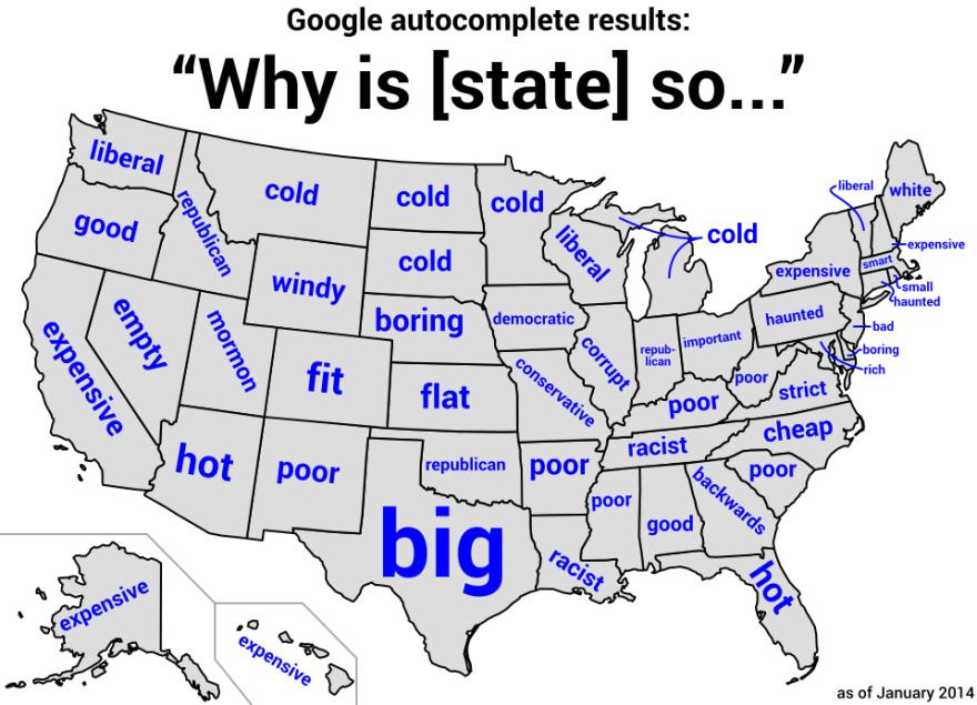
Mind you it is from 2014, but still fun.
Rio Hondo College GIS will be hosting a field exercise for aerial survey mapping at the Robert Redford Sustainability Center in Claremont on Saturday December 11th 9am to noon. Go check it out.
Check out this map of UFO sightings! The dataset the map uses contains over 80,000 records of UFO sightings over the past century (between 1910 and 2014), and the data displayed lapses from year to year. You can control which year’s data is displayed using the Time Widget at the bottom of the map. Check it out!

After reading up on what the US Census is doing to the 2020 Census data, I have to consider if I can really trust the data to be used for other applications?
You see, the US Census decided to use “differential privacy”, a mathematical technique to introduce statistical noise to “blur” the data. Their reasoning is that because we have powerful computers, anyone could use other data and cross reference the census data to find information on individuals. You can read about it from the US Census here.
However, what happens to the census data, especially at lower levels like the block level, they start messing around with actual numbers of people and other traits like ethnicity, age, sex, etc. For example, according to the US Census, 48 people live on New York’s Liberty Island, but actually no one has lived there since 2012. It also looks like some US States and organizations will be legally challenging the US Census data and the differential privacy technique. To be fair, the US Census has always implemented privacy safeguards using different techniques like “swapping”, but this new technique seems pretty drastic and really not needed. As data scientists duke it out, you can read all about this issue here.
Will you trust the 2020 Census data? You will need to look at it in your own jurisdiction. Burbank’s population strangely went down, so I need to investigate and look at the data more closely. We will need to determine if we can use this data at a tract, block group, or block level to make more informed and accurate decisions. As they say, your mileage may vary. They also say buyer beware!
