If you are into teaching GIS, check out this new site: TeachGIS.org.
TeachGIS.org
Reply

If you are into teaching GIS, check out this new site: TeachGIS.org.
Mark your calendars! Our next SoCalGIS meeting will be on May 9th, 2013 from 9am to 11:45 am at Culver City’s City Hall, 9700 Culver Blvd, Culver City, CA, in the City Council Chambers. Free underground parking.
Culver City will be hosting and showing us what they have been doing with GIS. There is also room for presentations by others, so if you want to present as well, just contact Michael Carson at mcarson@burbankca.gov or 818-238-5114.
Using a site that tracks dollar bills (Where’s George?), a theoretical physicist noticed that our state boundaries are rather arbitrary, but that money tends to stay within new, more realistic boundaries. Read the story here.

Our next SoCalGIS meeting will be hosted by the City of Culver City in May 2013. We will have a specific date and time soon.
If you would like to make a presentation at the meeting, please let me know so we can include you on the agenda. You can contact me, Michael Carson, GIS Manager, City of Burbank at mcarson@burbankca.gov or 818-238-5114. You can also use the SoCalGIS About page to leave a message as well.
The State of California has a new GeoPortal web site for access to geospatial data resources. Check it out at http://portal.gis.ca.gov .
The California Geological Survey (CGS) has developed a new online tool that allows you to search all of CGS’s Regulatory Maps, Landslide Maps, and Tsunami Maps. Also included are related reports and GIS data.
Regulatory Maps include:
Landslide Maps include:
Tsunami Maps include:
CGS will be adding more product to the warehouse. Visit their site at http://www.quake.ca.gov/gmaps/WH/index.htm .
From govloop.com and ESRI, a very cool infographic on how GIS technology powers our daily lives.

Take a look at the Sea Level Rise and Coastal Flooding Impacts application from NOAA.

Besides setting sea level rise up to 6 feet, you can also display levels of confidence of the inundation areas, flood frequency, and socioeconomic vulnerability of nearby communities.
Interesting tool for viewing different map projections.
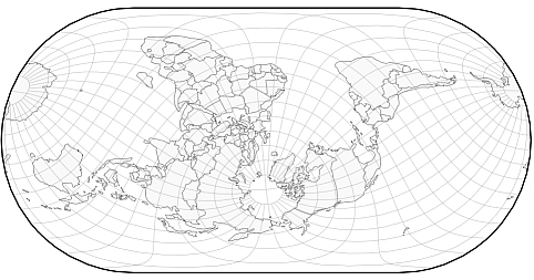
The globe is live in the tool so you can grab it and turn it to see the distortions near the edges. Best viewed in Chrome or Firefox.
The USGS announced the first look image from the Landsat Data Continuity Mission (LDCM). The image captures both the host institution of the NC CSC, Colorado State University, as well as the Galena fire scar just west of CSU. The NC CSC is a member node of the NASA Applied Sciences DEVELOP program and the director, Jeff Morisette, worked at NASA Goddard Space Flight Center for 10 year prior to joining the USGS. The center is integrating climate observations and models with remote sensing observation to help meet its mission of bringing the best available earth science to help land managers within the Department of Interior. See the full press release for more info.
